Method for splicing 3D seismic data convergence region structure diagrams

A 3D seismic and structural map technology, applied in the field of petroleum exploration, can solve problems such as geological information errors and deviations, and achieve the effect of improving precision and accuracy and reliable research basis

Inactive Publication Date: 2017-12-15
CHINA PETROLEUM & CHEM CORP +1
View PDF5 Cites 6 Cited by
  • Summary
  • Abstract
  • Description
  • Claims
  • Application Information

AI Technical Summary

Problems solved by technology

Therefore, the final results obtained will contain the human judgment of geological researchers, and there will be certain errors and deviations from the actual geological information.

Method used


Image

  • Method for splicing 3D seismic data convergence region structure diagrams
  • Method for splicing 3D seismic data convergence region structure diagrams
  • Method for splicing 3D seismic data convergence region structure diagrams

Examples


Embodiment Construction

[0017] In order to make the above and other objects, features and advantages of the present invention more comprehensible, the preferred embodiments are listed below and shown in the accompanying drawings in detail as follows.

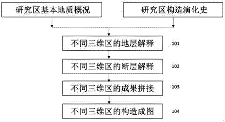
[0018] Such as figure 1 as shown, figure 1 It is a flow chart of the method for mosaicing structural maps of the three-dimensional seismic data intersection area of ​​the present invention. Before implementing the present invention, the basic geological situation and regional evolution process of the research area should be understood in detail. The structural movement and stress direction of the study area are analyzed to ensure that the next structural interpretation conforms to the geological conditions of the area, making the structural interpretation more reasonable.

[0019] Step 101: Stratigraphic Interpretation of Different 3D Zones

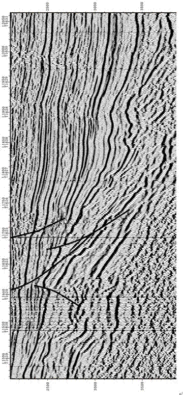
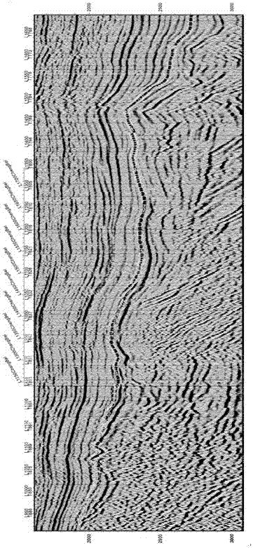
[0020] Firstly, finely track and interpret the same layer of different 3D seismic data, and obtain interpret...


PUM


Abstract

The present invention provides a method for splicing structural maps of the three-dimensional seismic data intersection area. The method for splicing the structural maps of the three-dimensional seismic data intersection area includes: step 1, understanding the basic geological situation of the research area, and collecting relevant data on structural evolution; Track and interpret different 3D seismic data for the same target horizon; step 3, interpret faults of different 3D seismic data for the same horizon; step 4, integrate different 3D interpretation results; step 5, perform depth domain conversion to form a structure picture. The structural map mosaic method of the 3D seismic data intersection area directly converts the interpretation results of the intersection area into geological language through the splicing of the interpretation results, effectively reducing the artificial errors and deviations in the structural map mosaic, and obtaining higher accuracy and precision. Structural maps can guide oil and gas exploration work more effectively.

Description

technical field [0001] The invention relates to the technical field of petroleum exploration, in particular to a method for splicing structural maps of three-dimensional seismic data intersection areas. Background technique [0002] The interpretation of seismic data is a very important link in oil exploration, and it is an important step to transform seismic data into geological language, which is related to whether seismic data can fully exert its geological effect. Seismic data interpretation results, that is, structural maps are an important basis for oil exploration, and their fineness and accuracy are key factors affecting exploration deployment. [0003] At present, it is an inevitable development trend to use the powerful processing ability of computer to help interpreters interpret seismic data. Many mature software products have been developed at home and abroad. LandMark and GeoFrame are widely used now. How to correctly and efficiently apply the functions and m...

Claims


Application Information

Patent Timeline
Patent Type & Authority Applications(China)
IPC IPC(8): G01V1/32
CPCG01V1/325
Inventor 王莉王永诗马立驰景安语孙锡文秦永霞张明华许淑芳孙耀庭刘菊庄梅李辉王志英谢传金毕俊凤王亚琳
Owner CHINA PETROLEUM & CHEM CORP
Why Eureka
Try Eureka