Attitude adjustment method for curve stripe imaging in agile satellite maneuver

An adjustment method and satellite technology, which can be applied to motor vehicles, attitude control, space navigation equipment, etc., can solve the problems of lack of attitude adjustment method, camera field of view can not cover the target, etc., and achieve the effect of improving the use efficiency

Active Publication Date: 2017-12-22
AEROSPACE DONGFANGHONG SATELLITE
View PDF7 Cites 16 Cited by
  • Summary
  • Abstract
  • Description
  • Claims
  • Application Information

AI Technical Summary

Problems solved by technology

The shortcomings of these two methods are mainly manifested in: (1) they are only suitable for the imaging of oblique strips, and for curved targets such as border lines and coastlines, it is still necessary to use multiple oblique strips to cover them; (2) they In the description of the strips and the calculation of the attitude angle,

Method used


Image

  • Attitude adjustment method for curve stripe imaging in agile satellite maneuver
  • Attitude adjustment method for curve stripe imaging in agile satellite maneuver
  • Attitude adjustment method for curve stripe imaging in agile satellite maneuver

Examples


Embodiment Construction

[0053] Below in conjunction with accompanying drawing and specific embodiment the present invention is described in further detail:

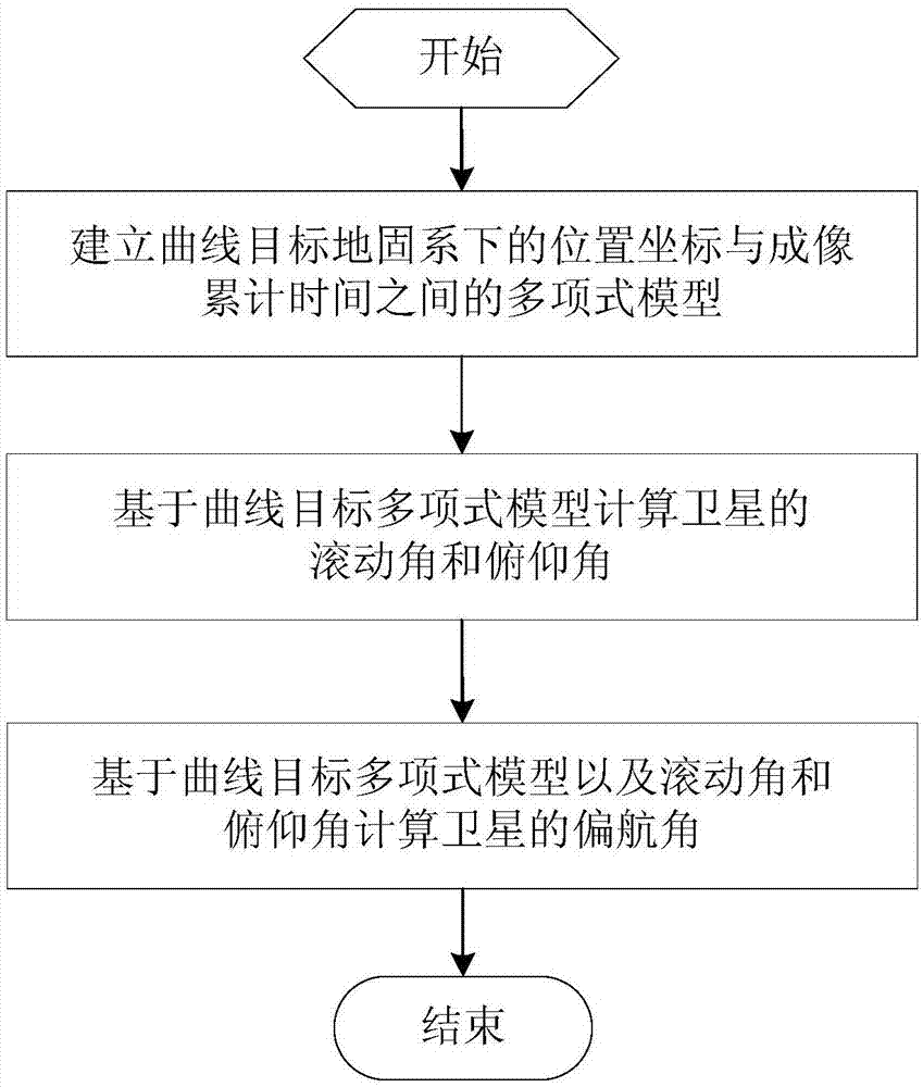
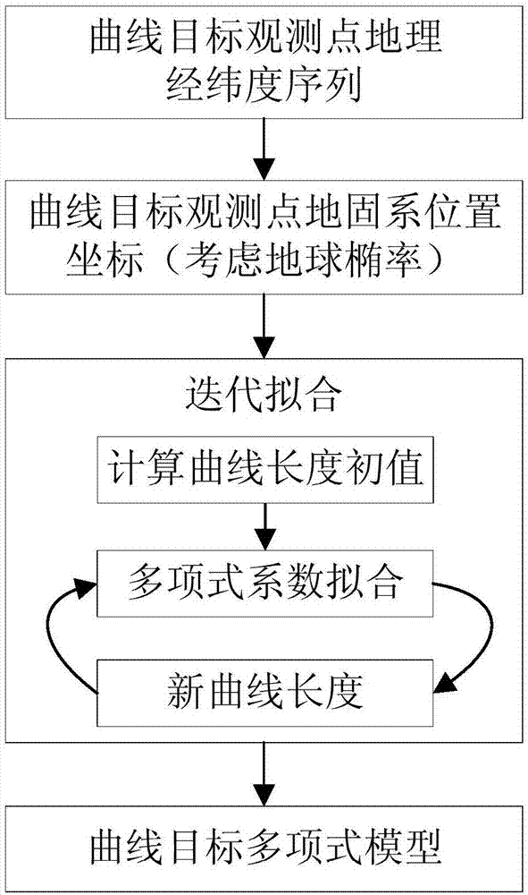
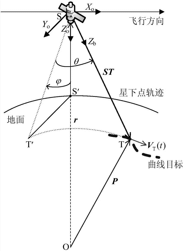
[0054] Such as figure 1 Shown is the flowchart of the attitude adjustment method of the present invention, the attitude adjustment method of the present invention specifically includes: (1) establishing a polynomial model between the position coordinates of the curved target in the ground-fixed coordinate system and the imaging accumulation time; (2) based on the steps (1) Calculate the roll angle and pitch angle of the satellite based on the obtained curve target polynomial model; (3) calculate the yaw of the satellite based on the curve target polynomial model obtained in step (1) and the roll angle and pitch angle obtained in step (2) horn. The method of the invention can be used for attitude planning of imaging along curved strips in agile satellite maneuvers.

[0055] The specific implementation steps of the attitude adjustment method of ...


PUM


Abstract

The present invention relates to an attitude adjustment method for curve stripe imaging in agile satellite maneuver. The method comprises the following steps that: (1) a polynomial model between the position coordinates of a curve target under an earth-fixed reference system and imaging cumulative time is established; (2) the roll angle and pitch angle of a satellite are calculated according to the polynomial model of the curve target obtained in step (1); and (3) the yaw angle of the satellite is calculated according to the polynomial model of the curve target obtained in step (1) and the roll angle and pitch angle obtained in the step (2). The method can support the one-time continuous imaging of curve targets along highways, coastlines and borderlines and can significantly improve the use efficiency of the in-orbit operation of the satellite. According to the method, the influence of the ellipticity of the earth is considered, and therefore, the target can be covered more accurately, and imaging quality is high. The method can be applied to the attitude planning of curve strip imaging in agile satellite maneuver.

Description

technical field [0001] The invention relates to the technical field of spacecraft attitude adjustment, in particular to an attitude adjustment method for imaging along curved strips during agile satellite maneuvers. Background technique [0002] Traditional optical remote sensing agile satellites generally rely on the orbital motion of the satellite to achieve push-broom imaging of the target area, and the imaging geographic area is parallel to the trajectory of the sub-satellite point. On the one hand, such satellites generally adopt sun-synchronous orbits, and their imaging coverage in the east-west longitude direction is relatively weak; Coverage is difficult to achieve with one or multiple strips in the same direction, or the coverage is very ineffective. With the rapid improvement of attitude maneuverability, the new agile satellite can adjust the boresight to the ground pointing for push-broom imaging through the real-time maneuver of attitude. This push-broom imagin...

Claims


Application Information

Patent Timeline
IPC IPC(8): G05D1/08
CPCB64G1/244
Inventor 陈雄姿谢松王抒雁于灵慧李志壮杨芳赵键张锐
Owner AEROSPACE DONGFANGHONG SATELLITE
Why Eureka
Try Eureka