An Adaptive Cascaded Kalman Filter Method Based on Dual Antenna GPS and MIMU Combination

A Kalman filter, dual-antenna technology, applied in radio wave measurement systems, satellite radio beacon positioning systems, instruments, etc., can solve the problems of low attitude measurement accuracy and large amount of calculation, achieve precise navigation accuracy and improve operation speed. , the effect of reducing the amount of calculation

Active Publication Date: 2020-09-11
王伟
View PDF6 Cites 0 Cited by
  • Summary
  • Abstract
  • Description
  • Claims
  • Application Information

AI Technical Summary

Problems solved by technology

[0005] The purpose of the present invention is to solve the problem of large amount of calculation in the prior art and the low accuracy of attitude measurement in the process of losing lock with GPS in the case of large misalignment angles, and propose an adaptive cascaded Karl based on the combination of dual-antenna GPS and MIMU Mann filtering method

Method used


Image

  • An Adaptive Cascaded Kalman Filter Method Based on Dual Antenna GPS and MIMU Combination
  • An Adaptive Cascaded Kalman Filter Method Based on Dual Antenna GPS and MIMU Combination
  • An Adaptive Cascaded Kalman Filter Method Based on Dual Antenna GPS and MIMU Combination

Examples


specific Embodiment approach 1

[0060] Specific embodiment one: the adaptive cascade Kalman filtering method based on dual-antenna GPS and MIMU combination comprises the following steps:

[0061] Step 1: Using the linear differential equation of the additive quaternion error to establish a state equation based on the additive quaternion error;

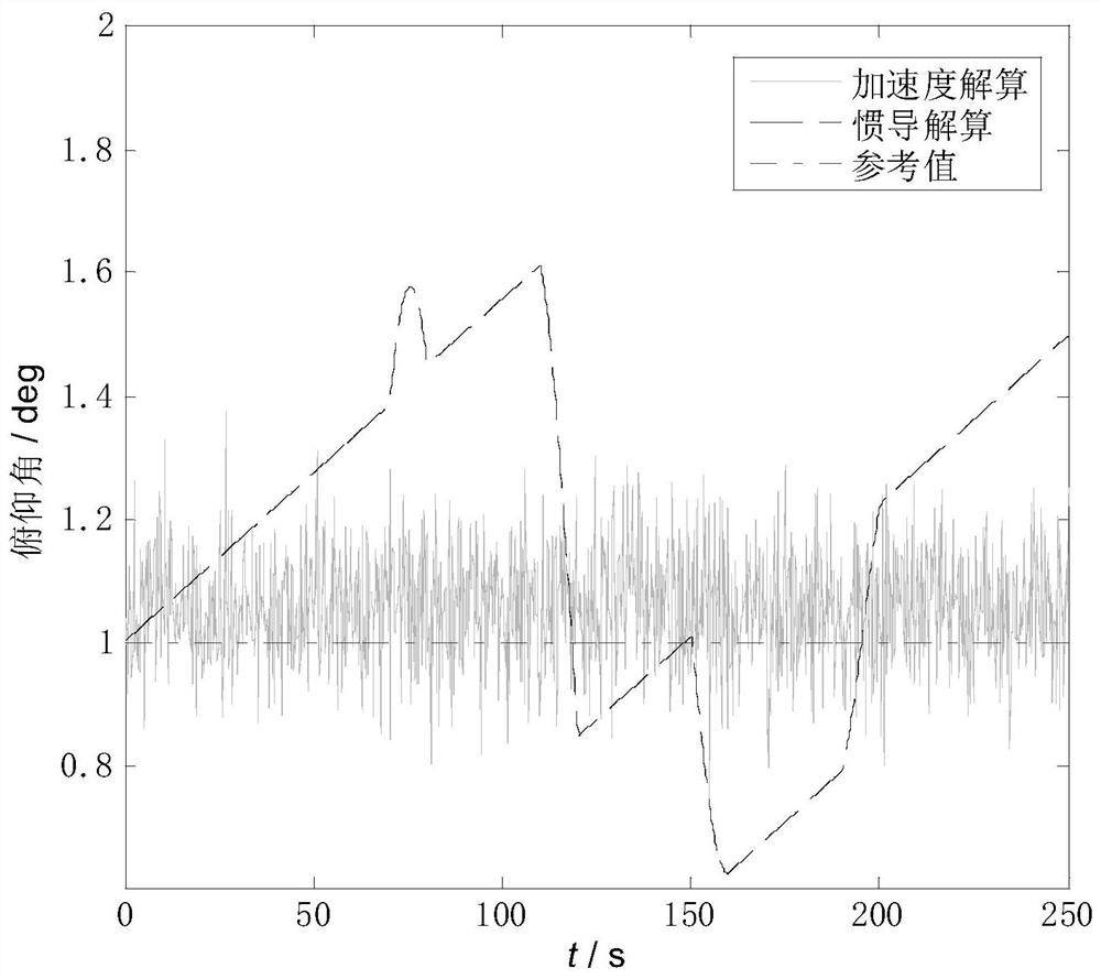
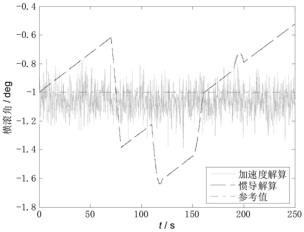
[0062] Step 2: Utilize the attitude angle of the carrier calculated by the inertial navigation system, and make a difference between the attitude angle of the carrier and the attitude angle provided by the accelerometer and GPS to obtain the attitude error angle of the carrier; the carrier is a vehicle, an aircraft, a ship, etc. For the carrier, the attitude angle includes pitch angle, roll angle and heading angle; the accelerometer calculates the pitch angle and roll angle, and the GPS provides the heading angle;

[0063] Step 3: Establish an observation equation according to the conversion relationship between the attitude error angle and the additive quaternion er...

specific Embodiment approach 2

[0069] Specific embodiment two: the difference between this embodiment and specific embodiment one is that: the linear differential equation of the additive quaternion error is utilized in the step one, and the specific process of establishing the state equation based on the additive quaternion error is:

[0070] Define δQ as the additive quaternion error, which satisfies formula (1):

[0071]

[0072] In the formula To calculate the quaternion is a scalar for computing quaternions, To calculate the vector of quaternions, Q=[q 0 q 1 q 2 q 3 ] T is a real quaternion, q 0 is a scalar of real quaternions, q 1 ,q 2 ,q 3 is a vector of real quaternions, δq 0 To calculate the difference between a quaternion and a real quaternion scalar, δq 1 、δq 2 、δq 3 To calculate the difference between the quaternion and the real quaternion vector; from the linear differential equation of the additive quaternion:

[0073]

[0074] In the formula is the first derivativ...

specific Embodiment approach 3

[0079] Specific embodiment three: the difference between this embodiment and specific embodiment one or two is: in the step three, according to the conversion relationship between the attitude error angle and the additive quaternion error, the specific process of establishing the observation equation is:

[0080] define Q e is the multiplicative quaternion error, which satisfies formula (4):

[0081]

[0082] In the formula is the quaternion multiplication algorithm, and Q e satisfy q e0 scalar for the multiplicative quaternion error, q e1 ,q e2 ,q e3 is a vector of multiplicative quaternion errors;

[0083] Combine (1) and (4) to get:

[0084]

[0085] The navigation coordinate system n is defined as the northeast sky geographic coordinate system. Due to the influence of initial deviation, measurement error, calculation error, etc., there is an angular deviation between the actual navigation coordinate system C and the real navigation coordinate system n, whic...


PUM


Abstract

The invention discloses a self-adaptive cascading Kalman filtering method based on a double-antenna GPS and MIMU (micro inertial measurement unit) integration and aims to solve the problems that the calculated amount is large and the attitude determination accuracy is low in the GPS lock loss process under the condition of the large misalignment angle in the prior art. The accuracy of navigation information such as posture, speeds and positions is improved by means of a self-adaptive attitude filter and a speed and position filter which are connected in series. The speed and position filter based on a speed and position error equation is established by use of corrected attitude information and the error amount between speed and position information provided by an inertial navigation system and a GPS. The speed and position errors and the drifting characters of an accelerometer are estimated, so that the navigation information of speeds, positions and the like are improved. The calculation burden is reduced through reduction of dimensionality, and the defect of large carrier attitude estimation error under the conditions of the large misalignment angle of the navigation direction and GPS lock loss is effectively overcome. The invention is applied to the field of integrated navigation.

Description

technical field [0001] The invention relates to the field of combined navigation, in particular to the field of dual-antenna GPS and MIMU combined navigation. Background technique [0002] The MEMS (Micro-Electro-Mechanical Systems)-based inertial measurement unit (MicroInertial Measurement Unit, MIMU) has a series of advantages such as small size and low cost, making its application prospects more and more broad. However, the accuracy of MEMS inertial devices is low, resulting in large estimation deviations in a short period of time. Therefore, GPS / MEMS integrated navigation is usually used to obtain long-term accurate navigation information. [0003] In view of the fact that inertial devices based on MEMS technology cannot achieve self-alignment, in order to obtain the initial heading angle, a combination of dual-antenna GPS and MIMU is usually used to provide more accurate heading information for the carrier under static and dynamic conditions; due to the low precision of...

Claims


Application Information

Patent Timeline
Patent Type & Authority Patents(China)
IPC IPC(8): G01C21/16G01S19/47G01S19/52G01S19/53
CPCG01C21/165G01S19/47G01S19/52G01S19/53
Inventor 王伟
Owner 王伟
Why Eureka
Try Eureka