Aerial triangulation free net building method based on minimum spanning tree for special unmanned aerial vehicle images

A construction method and technology for generating trees, which are applied to computer components, measuring devices, surveying and navigation, etc., can solve problems such as the inability to carry GPS/IMU systems, and the inability to directly obtain orientation elements outside difficult areas, etc., to achieve processing level and processing The effect of ability improvement

Active Publication Date: 2018-01-09
无锡子可科技有限公司
View PDF6 Cites 7 Cited by
  • Summary
  • Abstract
  • Description
  • Claims
  • Application Information

AI Technical Summary

Problems solved by technology

Even some UAV low-altitude remote sensing systems cannot be equipped with GPS/IMU systems, so they cannot directly obtain the outer orientation element

Method used


Image

  • Aerial triangulation free net building method based on minimum spanning tree for special unmanned aerial vehicle images
  • Aerial triangulation free net building method based on minimum spanning tree for special unmanned aerial vehicle images
  • Aerial triangulation free net building method based on minimum spanning tree for special unmanned aerial vehicle images

Examples


Embodiment Construction

[0048] Below in conjunction with the accompanying drawings, the technical scheme of the special UAV image air three free network construction method based on the minimum spanning tree provided by the present invention is further described, so that those skilled in the art can better understand the present invention and can implement it .

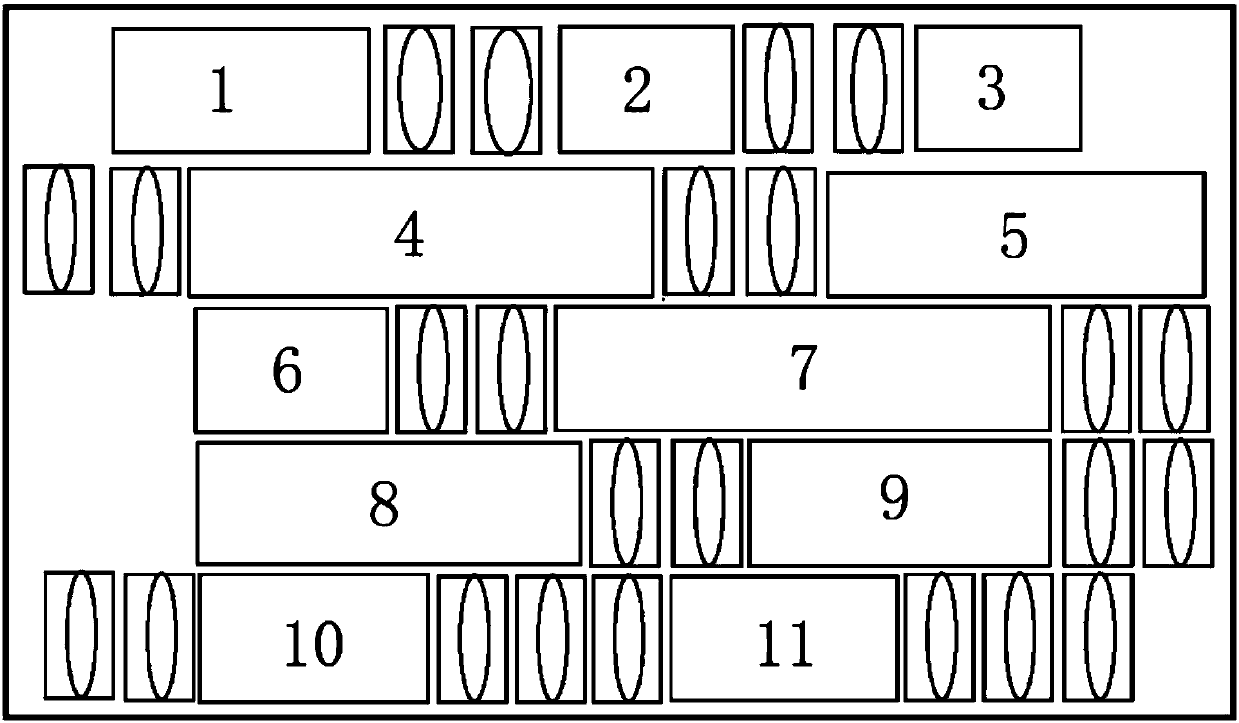
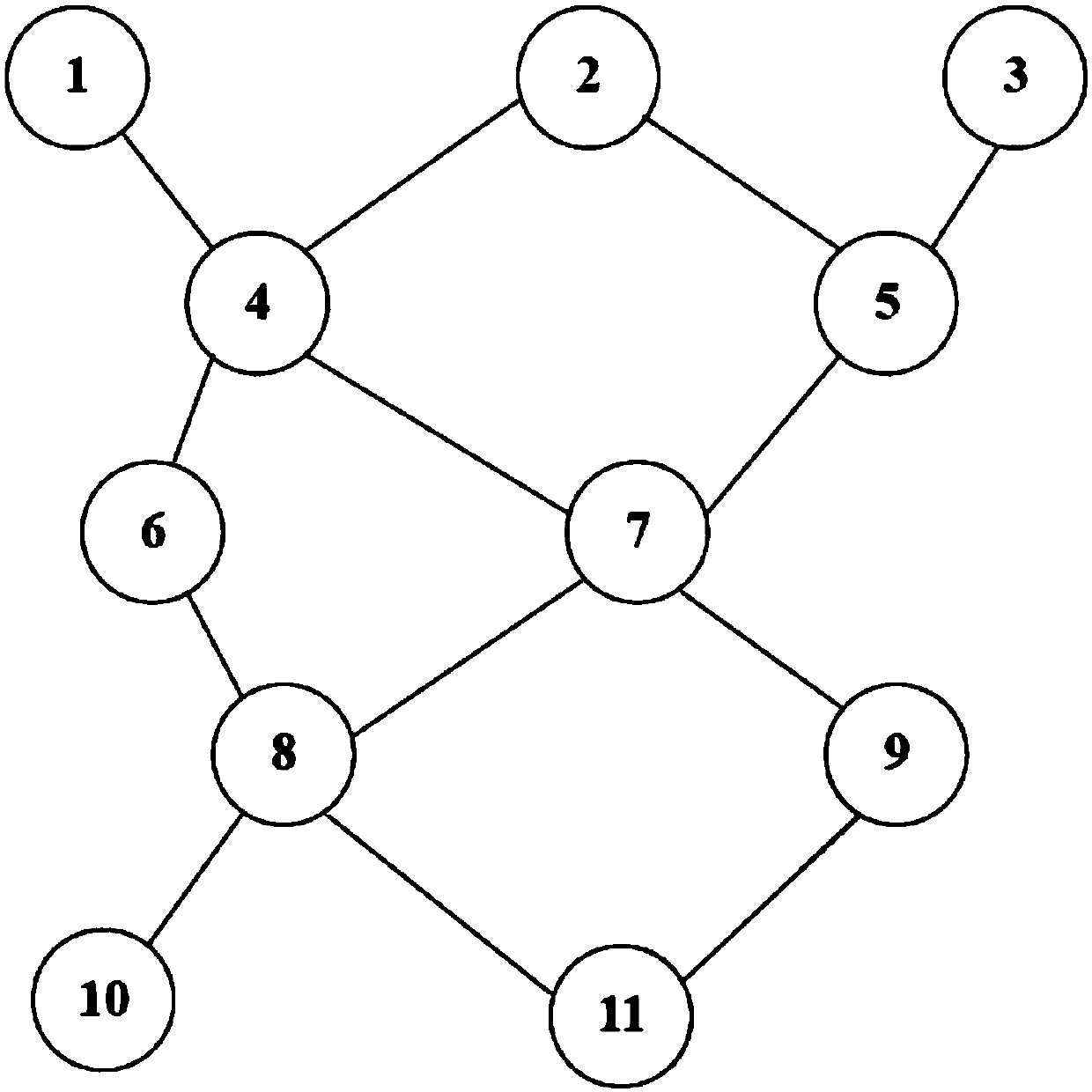
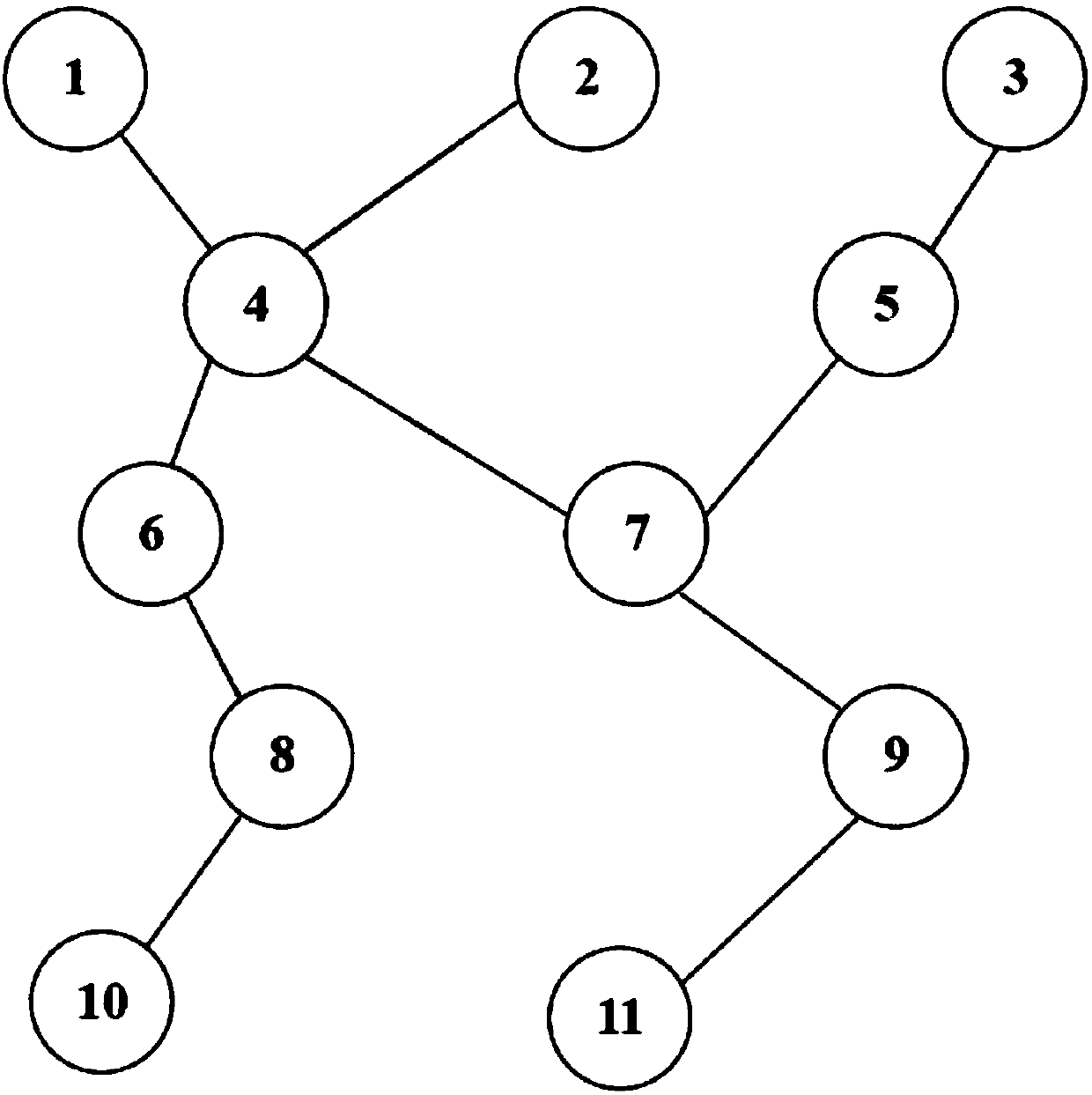
[0049] see Figure 1 to Figure 7 , the invention provides a method for constructing a special UAV image aerial three-dimensional free network based on a minimum spanning tree, for a class of special UAV images (such as large-area falling water, cloud occlusion, etc.) according to the conventional photogrammetry processing flow During aerial triangulation, often due to the failure of relative orientation and model connection, the automatic creation of flight belts fails and the aerial triangulation is interrupted, so that subsequent product production (such as DEM, orthophoto, etc.) cannot be performed. If the route is divided into several s...


PUM


Abstract

The invention provides an aerial triangulation free net building method based on a minimum spanning tree for special unmanned aerial vehicle images. For such special unmanned aerial vehicle images aswater falling, cloud shielding and overlapping holes, the problems of relative orientation, model connection failures and the like during conventional automatic aerial triangulation are solved; an aerial triangulation free net of the whole area is automatically built under the condition of not providing POS auxiliary data; exterior orientation elements of all images in a detected area and the initial values of object point coordinates are acquired; bundle-method block adjustment is performed; the exterior orientation elements of each image in the whole area and space coordinates of all objectpoints are wholly resolved. If a few of known control point coordinates are provided, the whole area can be incorporated into a control point ground coordinate system to realize absolute orientation.The processing level and the processing capability of the special unmanned aerial vehicle images are greatly improved.

Description

technical field [0001] The invention relates to a method for constructing a UAV image aerial three-free network, in particular to a method for constructing a special UAV image aerial three-free network based on a minimum spanning tree, and belongs to the technical field of UAV image processing methods. Background technique [0002] The low-altitude remote sensing system is a miniaturized and specialized remote sensing monitoring system with high mobility and low cost. It uses an unmanned aerial vehicle as a flight platform, high-resolution remote sensing equipment as an airborne sensor, and high-resolution remote sensing data as an application target. It has the ability to quickly and real-time investigate and monitor the ground. As a new remote sensing technology, its advantages are mainly reflected in the following aspects: First, it does not require an airport (in general, it is not necessary to apply for airspace), flexible lifting, and convenient for carrying out variou...

Claims


Application Information

Patent Timeline
IPC IPC(8): G01C3/10G01C11/02G06K9/00
Inventor 扆冰礼
Owner 无锡子可科技有限公司
Why Eureka
Try Eureka