Mean elevation plane triangulated irregular network-based topographic map elevation sparsing algorithm

A technology of average elevation and thinning algorithm, applied in the field of thinning of elevation points, it can solve the problems of curve deformation, efficiency influence, and inability to delete redundant points, and achieve the effect of good thinning effect.

Inactive Publication Date: 2018-01-16
武汉市测绘研究院
View PDF2 Cites 12 Cited by
  • Summary
  • Abstract
  • Description
  • Claims
  • Application Information

AI Technical Summary

Problems solved by technology

This method has two main disadvantages: 1. Points with large curve changes may be compressed due to thinning, resulting in curve deformation; 2. Some redundant points will be left behind and cannot be deleted.
Compared with the above two methods, the thinning accuracy of the Douglas-Puke algorithm is significantly improved. First, because the threshold value generally takes the maximum allowa...

Method used


Image

  • Mean elevation plane triangulated irregular network-based topographic map elevation sparsing algorithm
  • Mean elevation plane triangulated irregular network-based topographic map elevation sparsing algorithm

Examples


Embodiment Construction

[0027] In order to make the technical means, creative features, achievement goals and effects realized by the present invention easy to understand, the present invention will be further described below with reference to the specific embodiments.

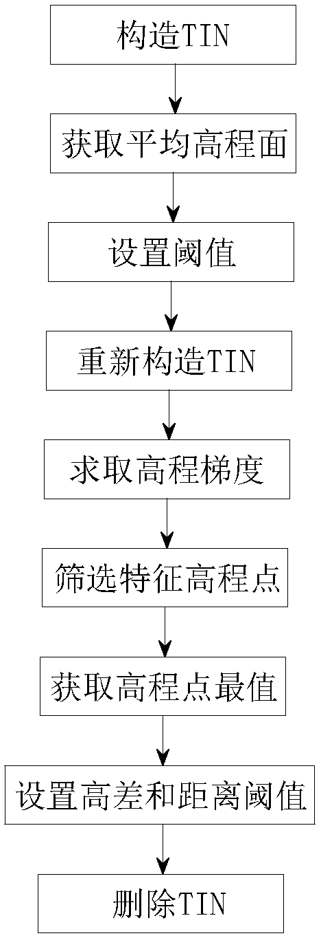
[0028] see Figure 1-2 , the present invention provides a technical solution: a topographic map elevation thinning algorithm based on an average elevation surface triangular network, comprising the following steps:

[0029] Step 1: Construct TIN; read all the elevation points to be thinned, construct TIN according to the position of these elevation points, the shape and size of TIN depend on the density and location of elevation point distribution;

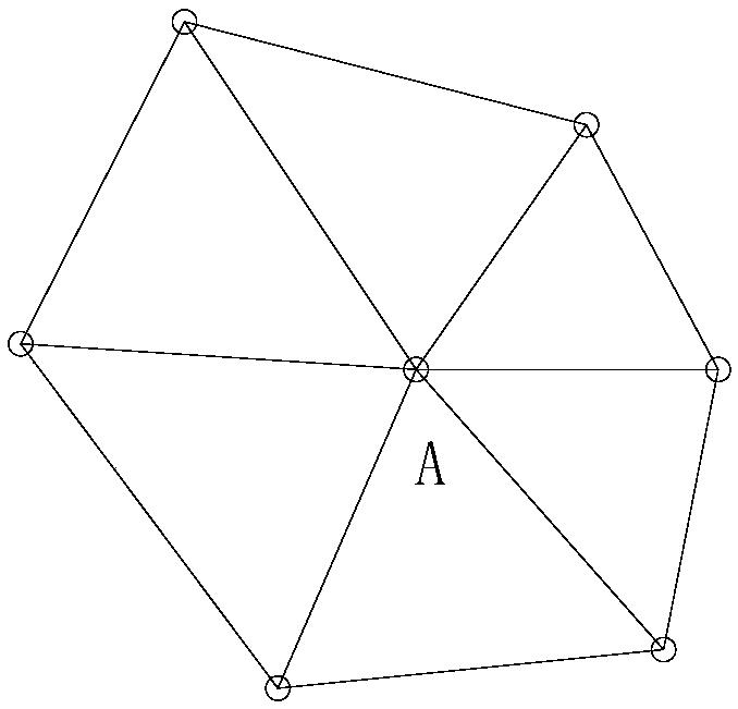
[0030] Step 2: Obtain an average elevation surface; traverse each elevation point to obtain its average elevation surface; the average elevation surface refers to a curved surface composed of triangles where each acquired elevation point is located;

[0031] Step 3: Set the threshold va...


PUM


Abstract

The invention relates to a mean elevation plane triangulated irregular network-based topographic map elevation sparsing algorithm. The sparsing algorithm comprises the following steps of constructinga triangulated irregular network; obtaining a mean elevation plane; setting a threshold; reconstructing the triangulated irregular network; calculating an elevation gradient; screening feature elevation points; obtaining an extreme value of the elevation points; setting a height difference and a distance threshold; and deleting the triangulated irregular network, wherein the triangulated irregularnetwork (TIN) refers to the triangulated irregular network generated by adopting a Delaunay triangulated network. According to the triangulated irregular network-based topographic map elevation pointsparsing algorithm, the elevation points capable of remarkably reflecting topographic relief change are reserved as far as possible, and the topographic change in a sparsing range is better expressed; the elevation points can be averagely distributed in a map, and the local topographic relief condition with remarkable and tiny height difference change is better reflected; and by utilizing methodsof the mean elevation plane, the elevation gradient and the like, the elevation points are screened and sparsed to achieve a reasonable topographic map downsizing effect.

Description

technical field [0001] The invention belongs to the field of thinning of elevation points in the process of compiling a series of scale topographic maps, in particular to a thinning algorithm of elevation points using TIN, average elevation surface and elevation gradient. Background technique [0002] In the process of downsizing a series of scale topographic maps, especially when a large-scale topographic map is reduced to a small-scale topographic map, the problem of thinning of elevation points is often encountered. In order to achieve a more reasonable downsizing effect, the traditional thinning usually requires Consider the distribution density of elevation points and terrain relief. At this stage, the method of TIN is mostly used to screen and thin the elevation points, but this method is relatively simple, and it is difficult to achieve a better downsizing effect. [0003] Digitizing the original large-scale topographic map is one of the important ways to obtain topo...

Claims


Application Information

Patent Timeline
IPC IPC(8): G06F17/30G01C5/00
Inventor 谭仁春曹文涛何伟彭清山李黎李海亭李琪江威张欢陈莎
Owner 武汉市测绘研究院
Why Eureka
Try Eureka