Method and apparatus for detecting tilt over level of pole tower

A technology of inclination and tower, applied in the direction of measurement device, measurement of inclination, surveying and navigation, etc., can solve the problems of low measurement accuracy, large workload and high risk, avoid large workload, and realize image and digital description. , the effect of easy archiving and post-management

Inactive Publication Date: 2018-01-26
广东电网有限责任公司机巡作业中心 +1
View PDF4 Cites 28 Cited by
  • Summary
  • Abstract
  • Description
  • Claims
  • Application Information

AI Technical Summary

Problems solved by technology

[0003] However, the existing method of measuring the inclination of the tower requires the staff to climb the tower, which has the disadvantages of large workload, high risk, low efficiency, and low measurement accuracy

Method used


Image

  • Method and apparatus for detecting tilt over level of pole tower
  • Method and apparatus for detecting tilt over level of pole tower
  • Method and apparatus for detecting tilt over level of pole tower

Examples


no. 1 example

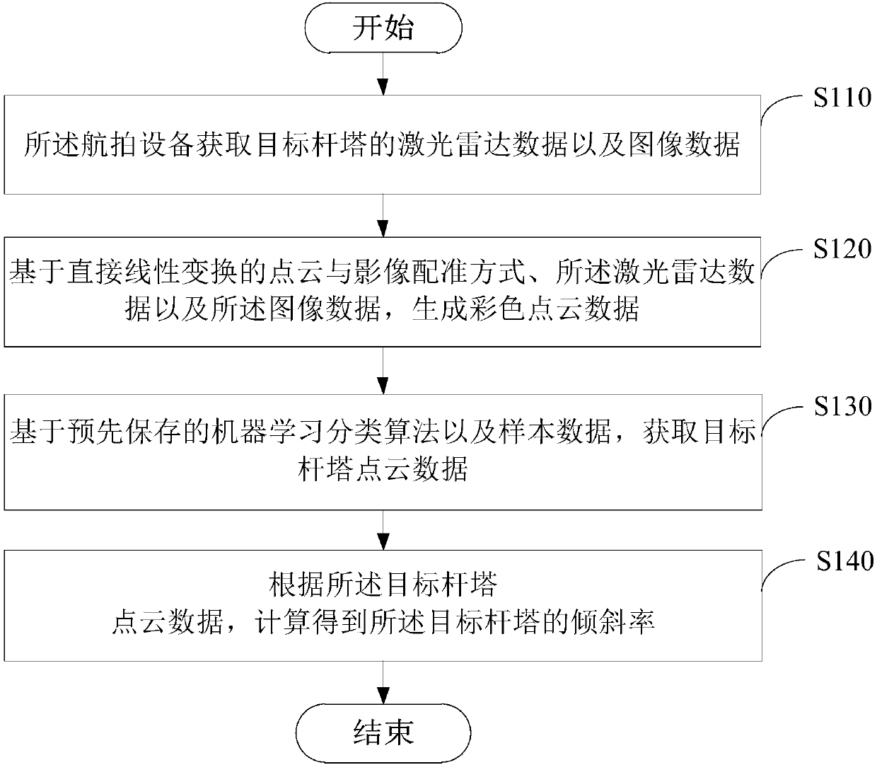
[0033] Please see figure 2 , figure 2 It is a flow chart of a method for detecting the inclination degree of a tower provided by an embodiment of the present invention, and the method is applied to aerial photography equipment, such as a drone. The methods include:

[0034] Step S110: the aerial photographing device acquires lidar data and image data of the target tower.

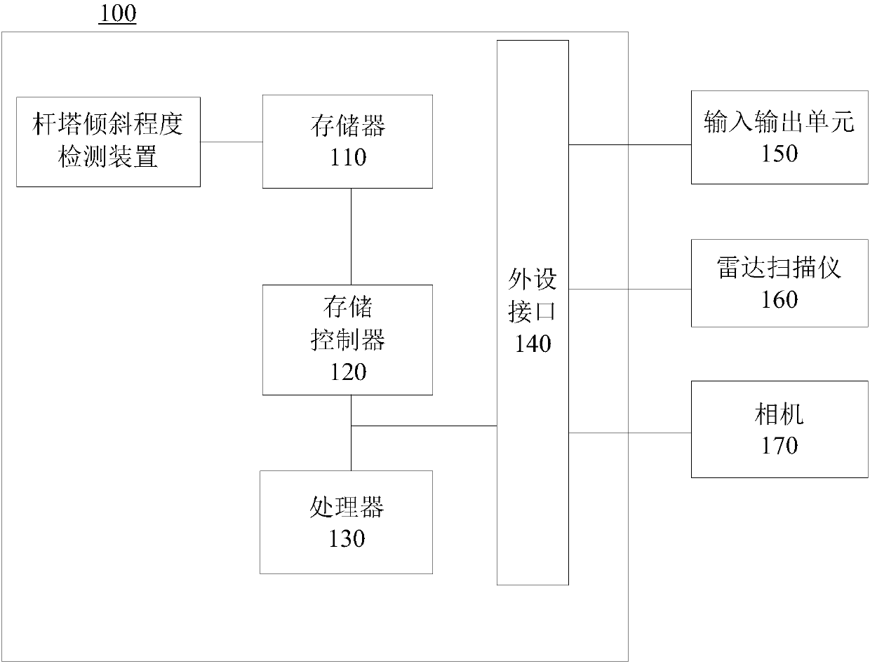
[0035] Wherein, a camera and a radar scanner are installed on the aerial photography equipment at the same time, and the processor of the aerial photography equipment can control the camera and the radar scanner to work at the same time, respectively collect the image data of the target tower and the laser radar data, and obtain the target The lidar data and image data of the tower are stored in the memory for subsequent processing. Collecting data at the same time can reduce the difficulty of data processing.

[0036] Step S120: Generate color point cloud data based on the point cloud and image regist...

no. 2 example

[0063] Please see Figure 6 , Figure 6 It is a structural block diagram of a tower inclination detection device 400 provided in the second embodiment of the present invention. The device is applied to aerial photography equipment. The following will be Figure 6 The illustrated structural block diagram is for illustration, and the illustrated device includes: a first acquisition module 410 , a generation module 420 , a second acquisition module 430 and a calculation module 440 .

[0064] The first acquisition module 410 is used to acquire lidar data and image data of the target tower;

[0065] The generation module 420 is used to generate color point cloud data based on the point cloud and image registration method of direct linear transformation, the lidar data and the image data;

[0066] The second acquisition module 430 is used to acquire point cloud data of target towers based on pre-saved machine learning classification algorithms and sample data;
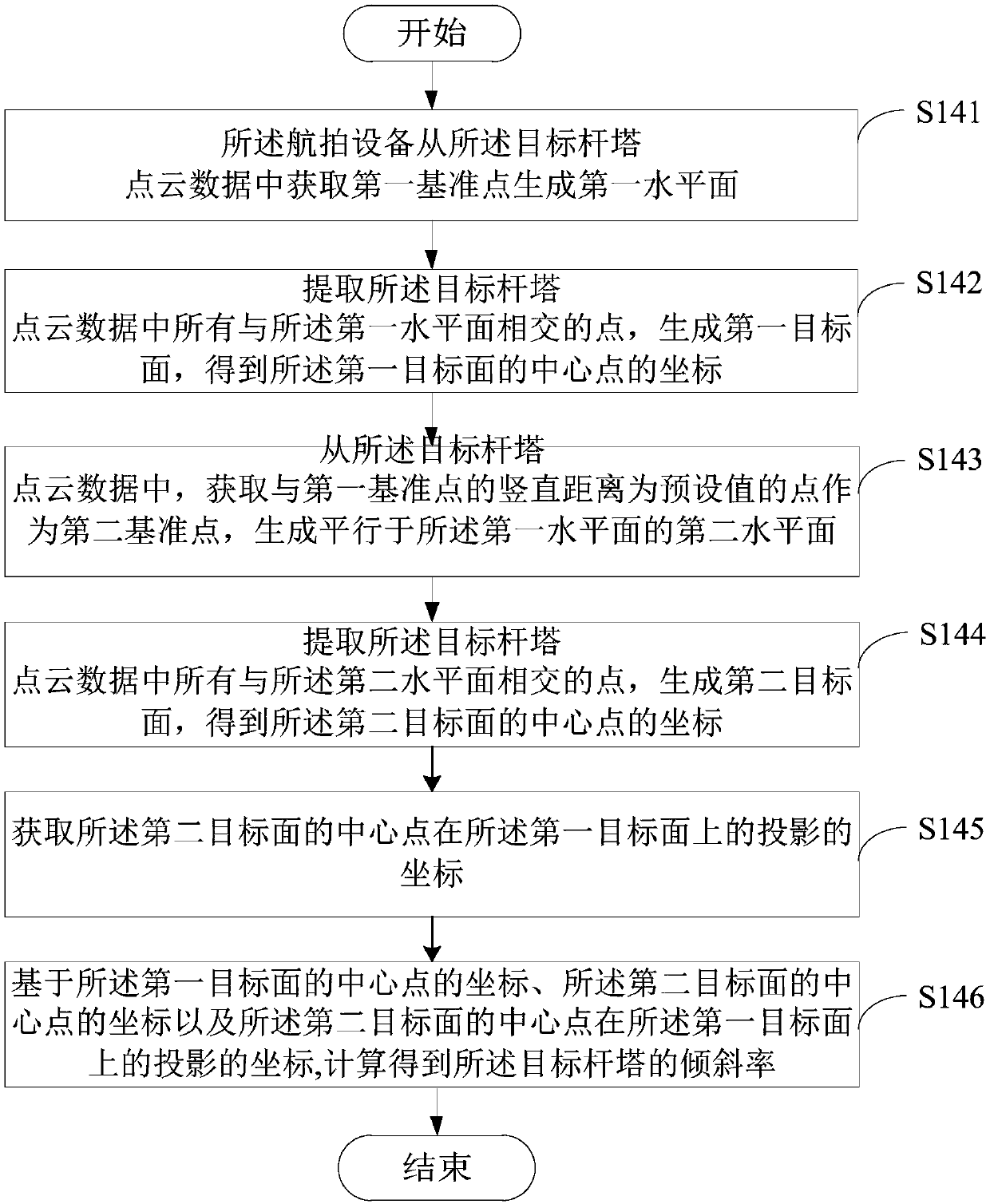
[0067] The calc...


PUM


Abstract

The embodiments of the invention provide a method and apparatus for detecting the tilt-over level of a pole tower. The method is applied to aerial photography devices. The method herein includes the following steps: an aerial photography device acquiring the laser radar data and image data of a target pole tower; based on the point cloud and image registration of direct linear transformation, thelaser radar data and the image data, generating color point cloud data; based on a pre-saved machine learning classification algorithm and sample data, acquiring the point cloud data of the target pole tower; and based on the point cloud data of the target pole tower, calculating the tilt-over rate of the target pole tower. The method herein can automatically measure the tilt-over level of a powerpole tower in a large area in an accurate manner, can present measurement data in images and data, and can facilitate achieve and follow-up management. Also, the method can avoid the problems of current measurement methods, such as heavy workload, high risks, and low efficiency.

Description

technical field [0001] The invention relates to the technical field of transmission line detection, in particular to a method and a device for detecting the inclination degree of a tower. Background technique [0002] The tower is one of the basic equipment in the transmission line, and the measurement of its inclination is an important part of the construction and operation and maintenance of the line. Because the pole tower is exposed to the outside for a long time, it is vulnerable to natural erosion and man-made damage, and it is prone to deformation or tilting, resulting in too small electrical safety distance, and even broken poles may occur. In urban areas or other densely populated areas and important intersections, once the tower falls, the consequences will be very serious. With the completion and operation of UHV transmission lines in my country, how to measure the inclination of transmission line towers with high precision and high efficiency is a matter of grea...

Claims


Application Information

Patent Timeline
Patent Type & Authority Applications(China)
IPC IPC(8): G06T7/00G06T7/30G06K9/62G01C9/00
Inventor 彭炽刚李雄刚蒙华伟张峰刘高廖建东王丛
Owner 广东电网有限责任公司机巡作业中心
Why Eureka
Try Eureka