Method for calculating irregular earth volume in engineering survey

An engineering measurement, irregular technology, applied in the direction of calculation, design optimization/simulation, special data processing application, etc., can solve the problem that the analysis of the results is not intuitive enough, can not see the current situation and the completed surface shape comparison and fill and cut analysis and other problems

Inactive Publication Date: 2018-02-09
中煤浙江测绘地理信息有限公司
View PDF8 Cites 7 Cited by
  • Summary
  • Abstract
  • Description
  • Claims
  • Application Information

AI Technical Summary

Problems solved by technology

[0015] Although this method can perform arbitrary subdivision and earthwork estimation on complex strata, it cannot visually and three-dimensionally see the comparison of the current situation and the completed surface shape and the analysis of filling and excavation after the earthwork calculation
If the current situation and the completed entity are both irregular surfaces, the analysis of the results is not intuitive enough

Method used


Image

  • Method for calculating irregular earth volume in engineering survey
  • Method for calculating irregular earth volume in engineering survey
  • Method for calculating irregular earth volume in engineering survey

Examples


Embodiment 1

[0051] The present embodiment is a method for irregular earthwork calculation in engineering survey, comprising the following steps:

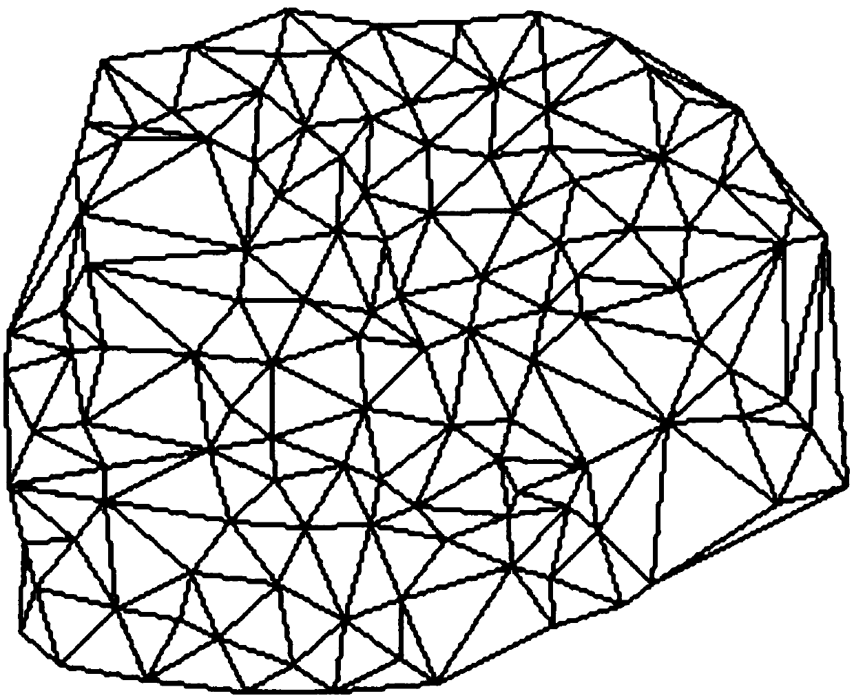
[0052] (1) Collect points according to the topography of the construction site, and all collection points cover the entire construction site along the boundary of the terrain.

[0053] The collection points are carried out by a total station or GPS, and each point distributes and stores X, Y, and Z coordinates, which correspond to north coordinates, east coordinates, and elevations respectively; collection points are generally collected every 5 to 10 meters according to terrain changes; On flat ground and with small slope changes, the distribution of collection points can be relatively sparse; on the ground with complex terrain and rapid changes in terrain, the distribution of collection points should be relatively dense.

[0054] This collection method can change the density and location of collection points with the complexity of terrain chan...

Embodiment 2

[0065] The difference between this embodiment and Embodiment 1 is that in step (2), during the extension process of the triangle, if there is a ground line in the construction site, the ground line must become a side of a certain triangle.

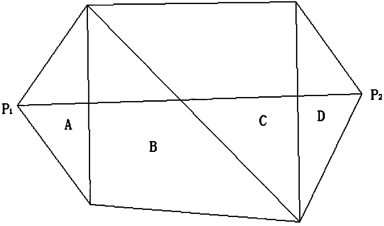
[0066] Through the above technical solutions, the ground line refers to the feature line that can fully express the shape of the terrain, and the ground line should not pass through any triangle, otherwise the triangle will "enter" or "suspend" on the ground, which does not match the actual terrain; The ground line coincides with one edge of a certain triangle, which can better express the terrain features.

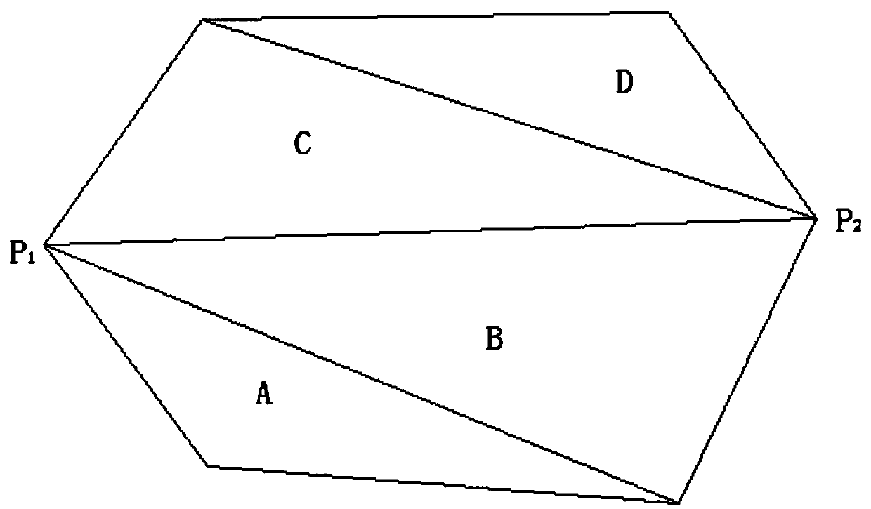
[0067] like figure 2 As shown, P 1 P 2 The connected straight line is the ground line, and A, B, C, and D are four triangles. The ground line passes through the triangles, causing the surface composed of the four triangles to be inconsistent with the actual terrain, so adjustments are required.

[0068] like image 3 As shown in ...

Embodiment 3

[0070] The difference between this embodiment and Embodiment 1 is that in step (2), during the extension process of the triangle, if there is a specific facility that cannot be dismantled in the construction site, a characteristic line is drawn on the edge of the specific facility, and according to the processing site Adjust the triangles by the linear method and remove all the triangles inside the breakline.

[0071] If there are some buildings or natural landscapes that cannot be dismantled on the construction site, the triangle must bypass this part of the facilities and form a blank in the area formed by the feature lines to avoid destroying the facilities during construction. like Figure 4 As shown in , the empty area in the center of the triangular surface is the facility that cannot be destroyed.

[0072] Generally, the "perpendicular line method" is used to judge whether the center of gravity of the triangle is located in the area of ​​the feature line. If so, the tr...


PUM


Abstract

The invention relates to a method for calculating an irregular earth volume in an engineering survey. The method comprises the following steps: (1) performing point collection on a terrain of a construction site, wherein all collecting points cover the whole construction site along a boundary of the terrain; (2) constructing a triangle with every three points and enabling these triangles to form acurved surface; (3) projecting each of the triangles to a reference surface to form a triangular prism and after superimposing, forming an integral current situation three-dimensional model; (4) fora design diagram of the terrain after completion, also forming an integral completion three-dimensional model using the steps 1-3; and (5) performing superimposition and comparison on the current situation three-dimensional model and the completion three-dimensional model, and respectively performing a substraction operation to respectively obtain three-dimensional models for a fill and an excavation. According to the method, specific ranges and forms of the fill and the excavation can be seen intuitively, and each three-dimensional coordinate, plane area, surface area, volume and the like areobtained by checking an entity, such that budget for the fill and the excavation can be performed better, and optimization selection is performed on a cost estimate and a scheme of the engineering.

Description

technical field [0001] The invention relates to an earthwork calculation method, in particular to a method for irregular earthwork calculation in engineering survey, and belongs to the field of engineering survey. Background technique [0002] Earthwork is to convert the existing irregular and uneven surface into a regular surface to meet the needs of construction projects. The calculation of earthwork is an important step in the construction of construction projects. In the design stage before the construction of the project, the amount of earth and stone must be estimated, that is, the amount of excavation and backfilling produced in the project must be calculated, which is directly related to the cost estimate and program selection of the project. In some engineering projects in reality, disputes arising from the accuracy of earthwork calculation are often encountered. [0003] At present, there are several commonly used methods for calculating earth volume: section met...

Claims


Application Information

Patent Timeline
Patent Type & Authority Applications(China)
IPC IPC(8): G06F17/50
CPCG06F30/20
Inventor 杜海军杨杭生赵晖
Owner 中煤浙江测绘地理信息有限公司
Why Eureka
Try Eureka