Method for calculating pose of vehicle at curve

A calculation method and technology for curves, applied in the field of vehicle pose calculation in curves, can solve the problems of inappropriate calculation, large error and high cost, and achieve the effect of small error, high accuracy and low accuracy.

Active Publication Date: 2018-02-16
HEBEI UNIV OF TECH
View PDF5 Cites 23 Cited by
  • Summary
  • Abstract
  • Description
  • Claims
  • Application Information

AI Technical Summary

Problems solved by technology

This method uses a method based on GPS positioning combined with vehicle visual pose calculation based on curved road surface characteristics, which can obtain high-precision pose information of the vehicle on the curved road, and overcomes the poor positioning accuracy and visual p

Method used


Image

  • Method for calculating pose of vehicle at curve
  • Method for calculating pose of vehicle at curve
  • Method for calculating pose of vehicle at curve

Examples


Embodiment 1

[0097] In this embodiment, the curve in front of the navigation building of Wuhan University of Technology is used as the test site, and all the pictures taken by the vehicle-mounted camera system are 1920*1200 (pixels).

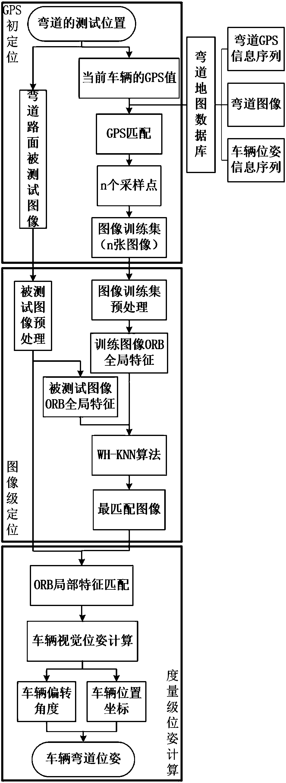
[0098] The vehicle pose calculation method of the curve in this embodiment includes the following steps:

[0099] The first step is to build a curve map database:

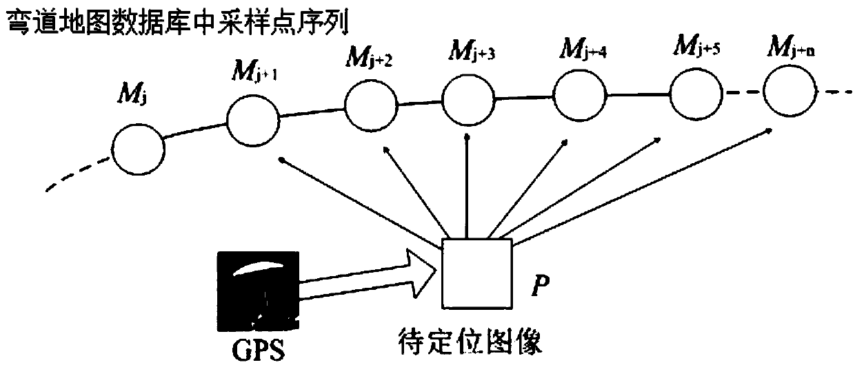
[0100] 1-1. Collection of curve GPS information sequence:

[0101] Use the on-board GPS acquisition device to obtain the current GPS value of the vehicle. The vehicle is at the road center of the curve and the body is parallel to the tangent of the curve to collect GPS information every 1m, and a total of 25 GPS values ​​are collected. The number of sampling points is also 25, and the GPS sequence of the curve can be obtained by traversing all the sampling points, which consists of 25 sets of latitude and longitude values;

[0102] 1-2. Collect curved road surface images:

[0103]The acquisit...

Embodiment 2

[0135] In addition to "choose the curved area in front of the Nautical Building of Wuhan University of Technology as the positioning area, in this area, GPS information is collected every 0.5 meters at the center of the curved road, and the GPS position is collected as the sampling point. Collect and store the GPS information sequence of the curve, the road surface image series of the curve sampling point, and the vehicle pose information sequence of the curve sampling point into the curve map database, thereby constructing the curve map database and performing 40 Group test experiment ", other is with embodiment 1.

Embodiment 3

[0137]In addition to "choose the curved area of ​​Chengxiao Road, Hebei University of Technology as the positioning area, in this area, GPS information is collected every 0.5 meters at the center of the curved road, and the GPS position is collected as the sampling point. Collect and store the GPS information sequence of the curve, the road surface image series of the curve sampling point, and the vehicle pose information sequence of the curve sampling point into the curve map database, thereby constructing the curve map database and performing 25 Group test experiment ", other is with embodiment 1.

[0138] After a series of comparisons between the real coordinates of the points to be located and the position coordinates calculated by the method of Examples 1-3, it is proved that the method of the present invention can realize high-precision calculation of the pose of the curved vehicle, and the calculation results are at the measurement level (centimeter level).

[0139] Wha...


PUM


Abstract

The invention relates to a method for calculating for calculating the pose of a vehicle at a curve. The method is based on a combination of GPS positioning and vehicle visual pose calculation based onthe characteristics of a curved road, and comprises the steps of firstly, performing initial positioning using GPS position information of the current vehicle, then matching a test image of the curved road with a curve map database, and finally, performing visual pose calculation according to the matched local feature points to obtain high-precision pose information of the vehicle at the curve. The method overcomes the defects that the existing method using a single GPS is poor in positioning precision and the existing visual pose calculation method is improper in curve pose calculation, andcan solve the problems of large error and high cost in curve vehicle pose calculation, thereby improving the precision of vehicle curve pose calculation.

Description

technical field [0001] The invention relates to an auxiliary driving technology for vehicle driving safety, in particular to a method for calculating the posture of a vehicle on a curve. Background technique [0002] The vehicle pose on a curve refers to the position and attitude of the vehicle when driving on a curve. The pose of the vehicle during driving is one of the important factors that affect driving safety. The real-time pose calculation of the vehicle is helpful for the driver to calculate the position according to the position. Make real-time adjustments to the posture state to reduce the probability of traffic accidents. Therefore, real-time and accurate calculation of vehicle pose is of great significance in lane keeping and assisted driving. Vehicle positioning is only the judgment of the vehicle position. The calculation of the vehicle position in a curve is called the positioning of the curved vehicle, and the positioning of the curved vehicle and the calcul...

Claims


Application Information

Patent Timeline
IPC IPC(8): G06K9/00G01S19/42G01B11/26
CPCG01B11/26G01S19/42G06V20/588
Inventor 胡钊政李玉婷
Owner HEBEI UNIV OF TECH
Why Eureka
Try Eureka