

Flood-prevention levee-inspection unmanned aerial vehicle
A technology of unmanned aerial vehicle and multi-rotor unmanned aerial vehicle, which is applied in the field of unmanned aerial vehicle for flood control and embankment inspection, can solve the problems of long time for flood control and flood control, high manpower demand and labor intensity, and easy to exceed the limit of human fatigue.
- Summary
- Abstract
- Description
- Claims
- Application Information
AI Technical Summary
Problems solved by technology
Method used
Image

Examples
Embodiment 1
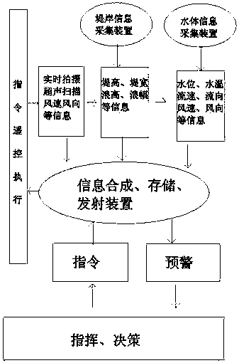
[0018] A flood control unmanned aerial vehicle, including a multi-rotor unmanned aerial vehicle, a camera device, a ground information collection device, an information synthesis, storage and transmission device, and an instruction receiving and transmitting device;
[0019] The camera device is installed at the bottom of the multi-rotor UAV, and the camera protrudes downward and can rotate 360 degrees;
[0020] The ground information collection device collects the data monitored by the embankment information collection device and the water body information collection device in real time during the dike patrol process through the corresponding frequency set; , including water level monitoring device, directional camera, ultrasonic detection device, soil water content monitoring device on the back of embankment, shore power supply and embankment information storage, transmitting and receiving device, continuous real-time monitoring of the highest water level, the lowest water ...
Embodiment 2
[0024] A flood control unmanned aerial vehicle, including a multi-rotor unmanned aerial vehicle, a camera device, a ground information collection device, an information synthesis, storage and transmission device, and an instruction receiving and transmitting device;
[0025] The camera device is installed at the bottom of the multi-rotor UAV, and the camera protrudes downward and can rotate 360 degrees;
[0026] The ground information collection device collects the data monitored by the embankment information collection device and the water body information collection device in real time during the dike patrol process through the corresponding frequency set; , including water level monitoring device, directional camera, ultrasonic detection device, soil water content monitoring device on the back of embankment, shore power supply and embankment information storage, transmitting and receiving device, continuous real-time monitoring of the highest water level, the lowest water ...
PUM
 Abstract
Description
Claims
Application Information