Method for extracting glacial lakes in highland area based on remote sensing satellite image

A technology of remote sensing satellite and extraction method, which is applied in the field of remote sensing, and can solve the problems of difficult identification of ice lakes, low efficiency of ice lake extraction methods, and inability to extract ice lakes on a large scale.

Active Publication Date: 2018-02-23
INST OF REMOTE SENSING & DIGITAL EARTH CHINESE ACADEMY OF SCI
View PDF3 Cites 25 Cited by
  • Summary
  • Abstract
  • Description
  • Claims
  • Application Information

AI Technical Summary

Problems solved by technology

Problems with this method: a large amount of human resources are needed, and it is greatly affected by the subjective experience of the judges. Some glacial lakes that are easily confused with the environment are difficult to identify, and it is impossible to quickly extract large-scale glacial lakes.
Problems with this method: this method is based on pixels, as long as the pixels that meet the threshold conditions will be extracted, it will generate noise in the process of ice lake extraction; secondly, for the mountain shadow that cannot be removed, It needs to be removed manually in the later stage; in addition, this type of method only starts from the perspective of the spectrum, but ignores the shape information of the ice lake, and the extracted ice lake boundary is often the boundary of some pixels, which makes the shape of the ice lake not smooth enough; Finally, the boundary information of the ice lake itself is relatively vague, so this method is not accurate enough to extract the boundary of the ice lake, especially on some small ice lakes that are easily confused with the surrounding environment
The problem with this method: the extraction accuracy of this type of method largely depends on the selection of tr

Method used


Image

  • Method for extracting glacial lakes in highland area based on remote sensing satellite image
  • Method for extracting glacial lakes in highland area based on remote sensing satellite image
  • Method for extracting glacial lakes in highland area based on remote sensing satellite image

Examples


Embodiment Construction

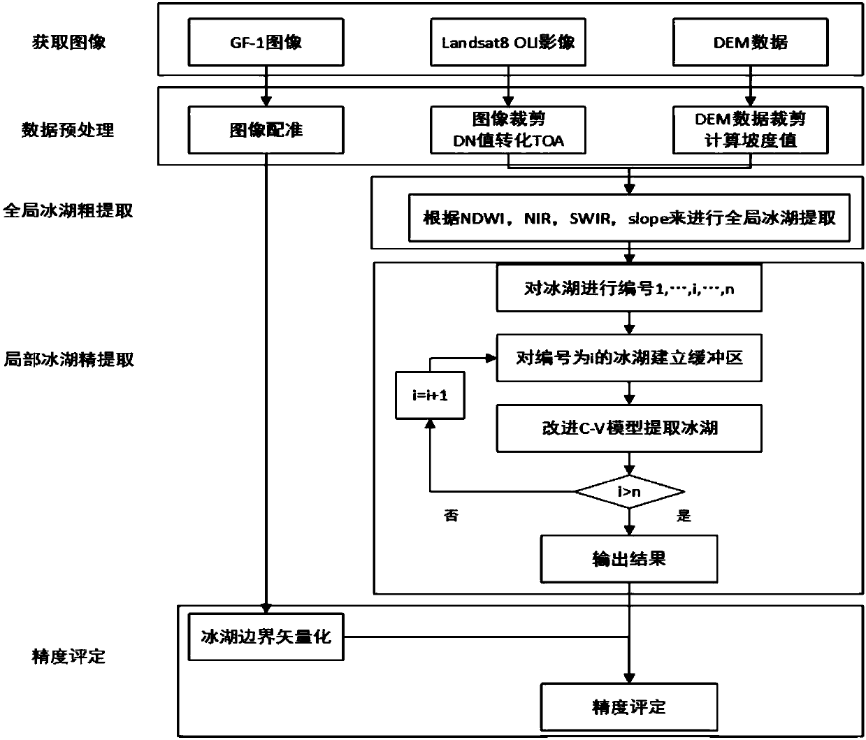
[0047] The present invention uses remote sensing images to extract ice lake information. Two problems need to be solved, one is the selection of data sources, and the other is the problem of an appropriate extraction method for the characteristics of ice lakes.

[0048] In the selection of data sources, considering that the extraction of glacial lakes should select data with higher spatial resolution and temporal resolution, and because it is difficult to remove the impact of mountain shadows by using only remote sensing image data, it is necessary to introduce spatial resolution For the 30-meter DEM (digital elevation model, DEM) data—ASTERV2 data, a slope model was established, and the influence of hill shadow was removed by combining the slope data. In summary, the final data source of this method is Landsat-8 data, whose spatial resolution is 30 meters, which can be well combined with DEM data, and whose temporal resolution is 16 days. This data can be stored in the geospat...


PUM


Abstract

The invention discloses a method for extracting glacial lakes in a highland area based on a remote sensing satellite image. The method comprises the steps of (1) obtaining the remote sensing satelliteimage and DEM data and carrying out pre-processing on the remote sensing satellite image and the DEM data, (2) carrying out global glacial lake crude extraction which comprises a step of obtaining anormalized different water index (NDWI) value of a whole region according to pre-processed remote sensing satellite image, combining a near infrared reflectance (NIR) value and a short wave infraredreflectance (SWIR) value, setting threshold values of NDWI, NIR and SWIR for the whole image, and eliminating the influences of glaciers and other ground features and a step of generating a slope mapof the area by using pre-processed DEM data, setting a slope threshold value and removing the effect of a hill shadow, and roughly extracting all glacial lakes and mixed backgrounds, and (3) carryingout local glacial lake fine extraction which comprises the steps of introducing a C-V model of a symbolic pressure function to accurately extract the glacial lakes one by one based on a result of glacial lake crude extraction. According to the extraction method of the invention, various factors affecting the extraction of the glacial lakes can be effectively removed, accurate extraction is achieved, and the method also has a good extraction result for smaller glacial lakes in the image.

Description

technical field [0001] The invention relates to the technical field of remote sensing, in particular to a method for extracting ice lakes in plateau regions based on remote sensing satellite images. Background technique [0002] Glacial lakes are considered to be one of the important factors that can reflect global changes, and they are the product of the joint action of global climate change and glacier retreat. The state of the glacial lake and its changes can not only reflect the overall change trend of the global climate, but also provide early warning for the evaluation of glacial lake outburst disasters. However, field surveys of glacial lakes are inefficient and difficult, so research on glacial lake information mostly focuses on the extraction and subsequent analysis of glacial lake information using remote sensing images. [0003] At present, there are few studies on ice lake extraction in remote sensing images, and the main methods can be divided into the followin...

Claims


Application Information

Patent Timeline
IPC IPC(8): G06T7/194G06T7/136G06T7/33G06T5/30G06T5/00
CPCG06T5/002G06T5/30G06T2207/10032G06T2207/20132G06T7/136G06T7/194G06T7/344
Inventor 陈方赵航张美美
Owner INST OF REMOTE SENSING & DIGITAL EARTH CHINESE ACADEMY OF SCI
Why Eureka
Try Eureka