Method for quantitatively describing forest clustering effect through three-dimensional point cloud data

A three-dimensional point cloud and point cloud data technology, which is applied to the details of 3D image data, the use of re-radiation, and image data processing, etc., which can solve the problem of drastic changes in the aggregation index, incomplete point cloud data, and inability to reflect aggregation effects. And other issues

Active Publication Date: 2018-03-23
NANJING UNIV
View PDF4 Cites 14 Cited by
  • Summary
  • Abstract
  • Description
  • Claims
  • Application Information

AI Technical Summary

Problems solved by technology

For example, the horizontal or vertical slicing method is not suitable for forest canopy point cloud data obtained from a single station hemisphere, because the point cloud data is incomplete
For the forest canopy point cloud data acquired by multiple stations, the aggregation effect at different times cannot be reflected only through horizontal or vertical slices, because in the low-to-medium density forest quadrats, the aggregation index changes drastically with the incident angle of the sun

Method used


Image

  • Method for quantitatively describing forest clustering effect through three-dimensional point cloud data
  • Method for quantitatively describing forest clustering effect through three-dimensional point cloud data
  • Method for quantitatively describing forest clustering effect through three-dimensional point cloud data

Examples


Embodiment Construction

[0032] The present invention will be further described below by specific examples:

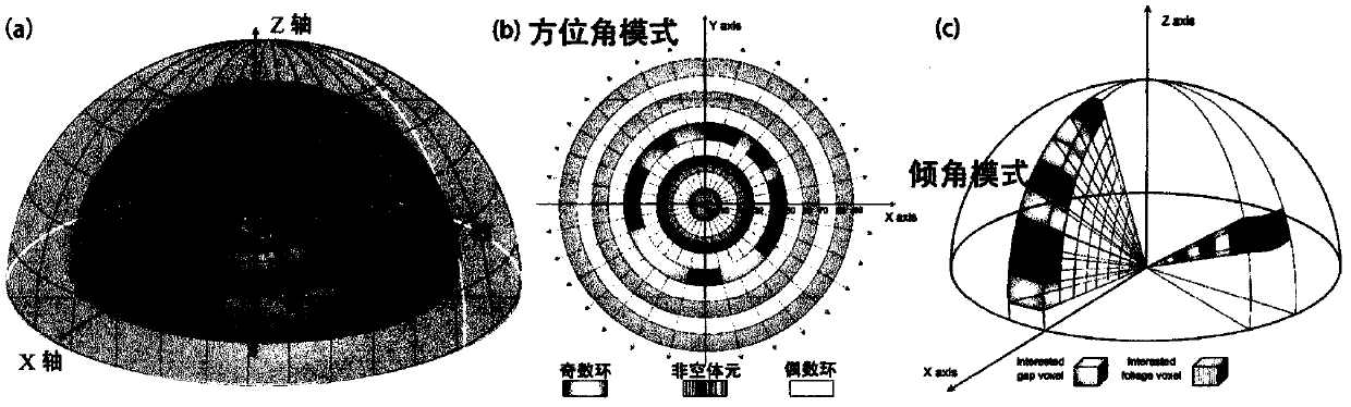
[0033] Use the ground three-dimensional lidar scanner Leica ScanStation 2 to obtain the forest quadrat point cloud data according to the technical scheme step (1), including the single-station hemisphere scanning mode and the multi-station scanning mode ( figure 1 ). Three high-, medium-, and low-density quadrats with different densities (4.00, 1.30, and 0.71) were selected as the research objects. The high-density quadrats were coniferous forests, and the medium-low density quadrats were broad-leaved forests. In order to obtain the canopy pore size distribution accurately, the sampling interval was set to 10mm@10m in the high- and medium-density quadrats, and 15mm@10m in the low-density quadrats.

[0034] The data in the single-station hemispheric scanning mode were acquired at the center of the forest quadrat, and the points outside the circular area with a radius of 30m were removed. Thro...


PUM


Abstract

The invention provides a method for quantitatively describing the forest clustering effect through three-dimensional point cloud data, which belongs to the research field of vegetation remote sensinginversion parameter methods. The method comprises the steps that three-dimensional point cloud data of the forest canopy in different modes are acquired, wherein a single station hemispherical mode and a multi-station mode are included; hemispherical slicing is carried out on the point cloud data acquired in the single station hemispherical mode to acquire pore size distribution in a dip or azimuth mode, and directional slicing is carried out on the point cloud data acquired in the multi-station mode to acquire the pore size distribution in any direction; according to the pore size distribution and a CC method, the arbitrary position omega-2 of a forest quadrat is acquired; for the coniferous forest, omega-1 is calculated based on the point cloud data of a cluster; and finally the forest canopy element aggregation index omega= omega-2/omega-1 is acquired. Compared with the canopy omega calculated by a traditional optical instrument, the method provided by the invention has the advantages of high accuracy and high applicability, is not affected by the light environment, scattered radiation and penumbra effect, and can invert omega at any position and time in a forest.

Description

1. Technical field [0001] The present invention is a method for quantitatively and accurately describing the forest aggregation effect through three-dimensional point cloud data. Specifically, it refers to a method for obtaining three-dimensional point cloud data of the forest canopy through ground laser radar technology, and accurately obtaining the pore size distribution. The method for retrieving forest canopy concentration index belongs to the research field of vegetation remote sensing inversion parameter method. 2. Background technology [0002] The forest canopy concentration (Ω) index was used to quantitatively describe the degree of non-random distribution of canopy elements. Accurate inversion of forest canopy aggregation index can effectively improve the inversion accuracy of forest physical and chemical parameters, and is also beneficial to a better understanding of forest canopy radiation distribution and physiological processes. The forest canopy leaf area ind...

Claims


Application Information

Patent Timeline
Patent Type & Authority Applications(China)
IPC IPC(8): G01S17/06G06T17/05
CPCG06T17/05G01S17/06G06T2207/10028G06T2207/10044G06T2200/08G06T2200/04Y02A90/10
Inventor 郑光马利霞居为民王晓菲路璐云增鑫
Owner NANJING UNIV
Why Eureka
Try Eureka