Piecewise affine transformation model-based city remote sensing image splicing method and apparatus

A technology of affine transformation model and transformation model, which is applied in the field of remote sensing image processing, can solve the problems of inability to accurately reflect the positional relationship of adjacent CCD images, and it is difficult to ensure the stitching accuracy of multi-line array CCD images, so as to avoid unreasonable segmentation, The effect of guaranteeing accuracy

Active Publication Date: 2018-03-27
THE 28TH RES INST OF CHINA ELECTRONICS TECH GROUP CORP
View PDF5 Cites 7 Cited by
  • Summary
  • Abstract
  • Description
  • Claims
  • Application Information

AI Technical Summary

Problems solved by technology

[0004] The above methods basically use the segmented affine transformation model to complete the splicing of adjacent images, but the segmented methods do not carry out quantitative and refined processing according to the specific changes in the offset between slices, and cannot accurately reflect the adjacent CCD images. Therefore, it is difficult to ensure the stitching accuracy of multi-line array CCD images

Method used


Image

  • Piecewise affine transformation model-based city remote sensing image splicing method and apparatus
  • Piecewise affine transformation model-based city remote sensing image splicing method and apparatus
  • Piecewise affine transformation model-based city remote sensing image splicing method and apparatus

Examples


Embodiment Construction

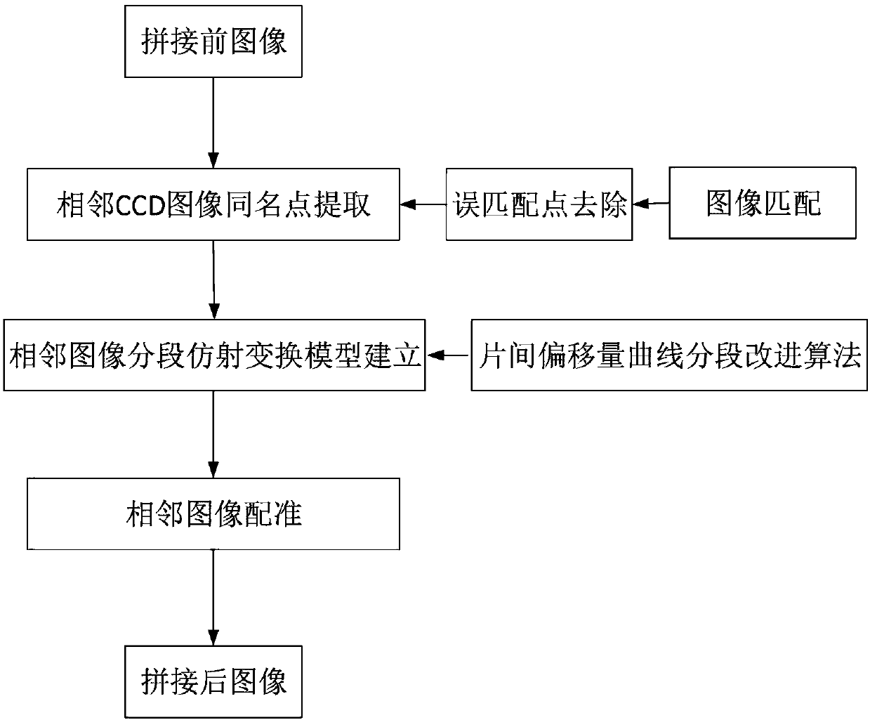
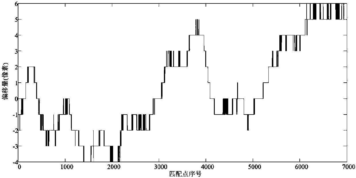
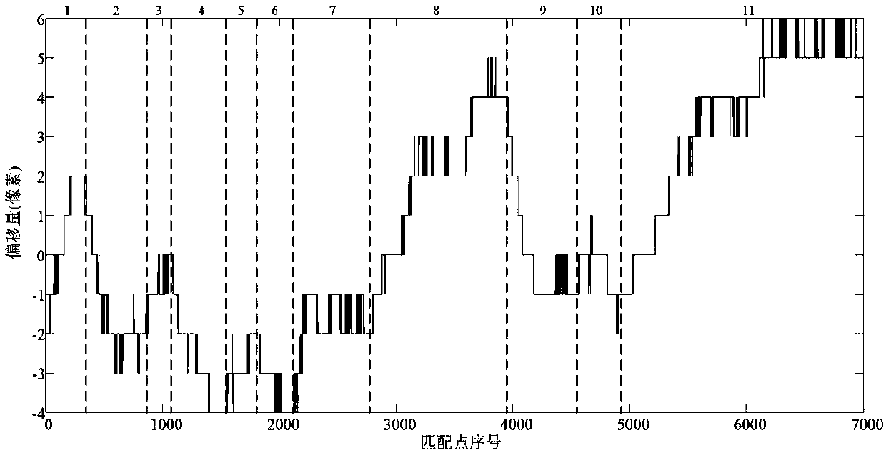
[0066] In order to make the purpose, technical solutions and advantages of the present invention clearer, the present invention will be described in further detail below in conjunction with the accompanying drawings and embodiments. It should be understood that the specific embodiments described here are only used to explain the present invention and are not intended to limit the invention.

[0067] Reference will now be made in detail to embodiments of the invention, examples of which are illustrated in the accompanying drawings. The suffixes "module" and "unit" of elements are used here for convenience of description, and thus may be used interchangeably without any distinguishable meaning or function.

[0068] Although all elements or units constituting an embodiment of the present invention are described as being incorporated into a single element or operated as a single element or unit, the present invention is not necessarily limited to such an embodiment. According to ...


PUM


Abstract

The invention provides an improved piecewise affine transformation model-based city remote sensing image splicing method. The method comprises the steps of firstly, for city remote sensing images obtained by a satellite-borne non-colinear multi-line array CCD camera, obtaining dense matching points of an image overlapping region by adopting a normalized image matching algorithm, and removing mismatching points in the dense matching points to obtain homonymy points capable of really reflecting an inter-piece relative position relationship; secondly, converting a coordinate position relationshipof homonymy point pairs of the overlapping region into an inter-piece offset curve, and performing segmentation on the inter-piece offset curve according to an overall change trend and local change characteristics of the inter-piece offset curve, thereby ensuring curves in all segments to be nearly linear; and finally according to a segmentation result of the offset curve, performing segmentationon corresponding image pairs, building an inter-image affine transformation model in each segment, and performing registration on the images, thereby realizing the splicing of the adjacent images. Therefore, the problem of the splicing of the city remote sensing images obtained by the non-colinear multi-line array CCD camera is solved.

Description

technical field [0001] This patent relates to a method for mosaicing urban remote sensing images based on a segmented affine transformation model, which belongs to the field of remote sensing image processing. Background technique [0002] Non-collinear multi-line array CCD cameras are widely carried on remote sensing satellites due to their advantages of high resolution and high width, and the images they form play a huge role in urban planning, urban building extraction, urban natural disaster monitoring, etc. . [0003] The non-collinear multi-linear array CCD remote sensing image is composed of multiple sub-images that are mutually dislocated, so they must be spliced ​​to form a seamless complete image before application. The relative position relationship between adjacent sub-images will change with the change of satellite attitude and the fluctuation of surface elevation, and the change is irregular, which can be clearly seen from the inter-slice offset curve. Theref...

Claims


Application Information

Patent Timeline
IPC IPC(8): G06T3/40G06T3/00G06T5/40G06T7/33G06K9/62
CPCG06T3/4038G06T5/40G06T7/344G06T2200/32G06T2207/20021G06T2207/10032G06F18/23G06T3/02
Inventor 黄利孙亭李毅满青珊沈自然林宇陈思
Owner THE 28TH RES INST OF CHINA ELECTRONICS TECH GROUP CORP
Why Eureka
Try Eureka