GNSS double antenna aided multi-sensor combined navigation system and method

An integrated navigation system and multi-sensor technology, applied in the field of multi-sensor integrated navigation system, can solve problems such as inability to improve speed and position information, error in navigation results, failure to meet user needs, etc.

Inactive Publication Date: 2018-04-13
CHANGGUANG SATELLITE TECH CO LTD
View PDF5 Cites 13 Cited by
  • Summary
  • Abstract
  • Description
  • Claims
  • Application Information

AI Technical Summary

Problems solved by technology

[0002] Traditional integrated navigation products use the combination of IMU and GPS, relying too much on GPS performance. However, in modern cities, there are tall buildings and trees, and GPS signals are easily blocked. When GPS gives wrong observation values, the entire navigation result will be wrong, which will bring many

Method used


Image

  • GNSS double antenna aided multi-sensor combined navigation system and method
  • GNSS double antenna aided multi-sensor combined navigation system and method
  • GNSS double antenna aided multi-sensor combined navigation system and method

Examples


Embodiment Construction

[0026] The present invention will be described in further detail below in conjunction with the accompanying drawings and embodiments.

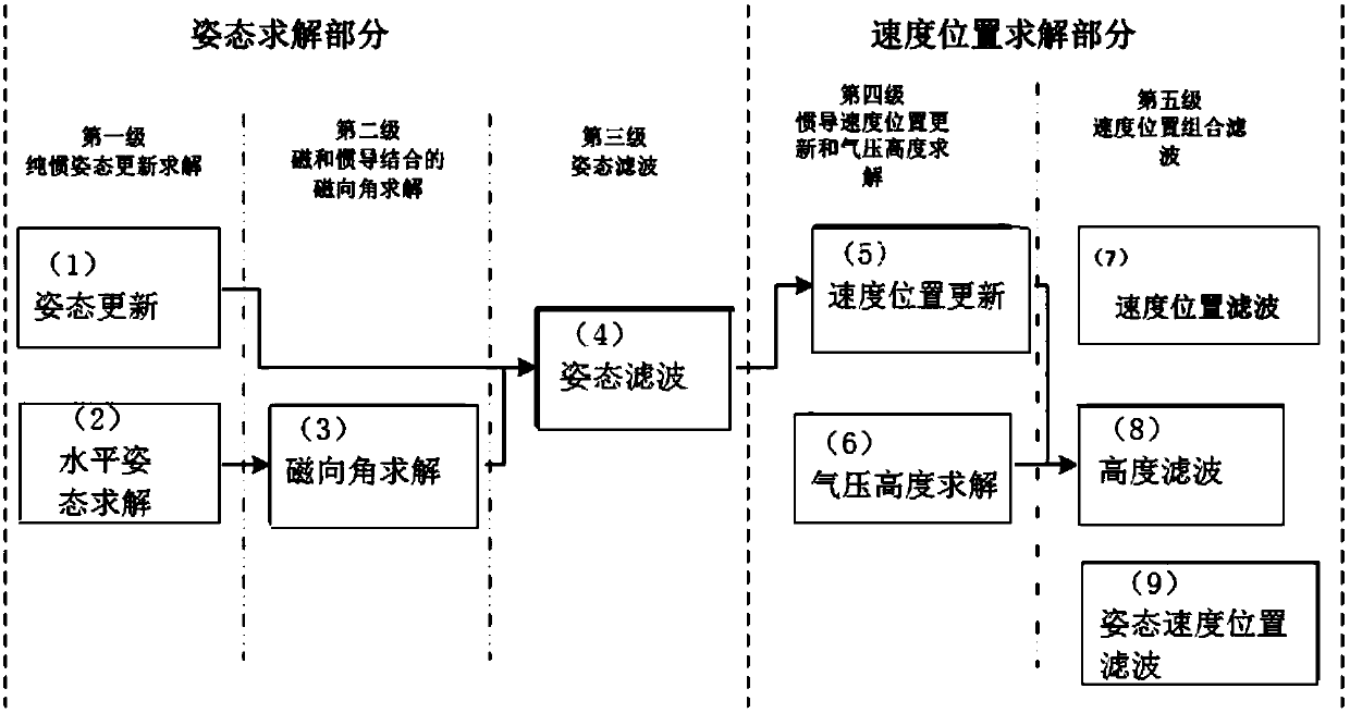
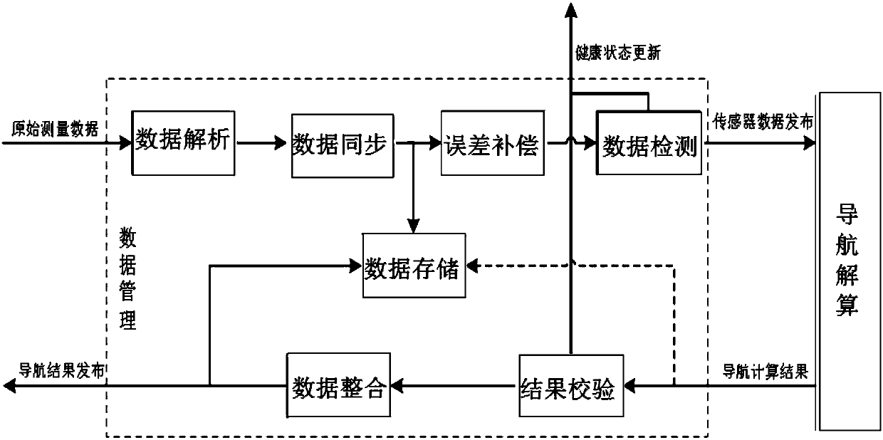
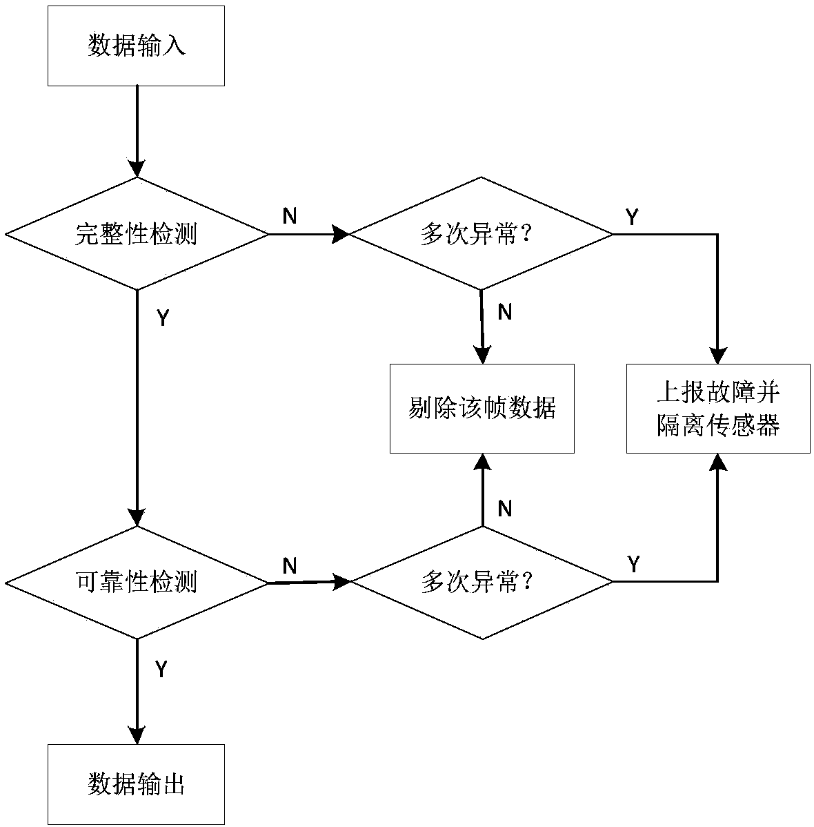
[0027] A GNSS dual-antenna assisted multi-sensor integrated navigation system includes a sensor group, a data management module and a Kalman filter. The sensor group includes a barometer, a magnetometer, an accelerometer, a gyroscope and GNSS dual antennas; the barometer measures the air pressure altitude of the carrier, which can be output as a separate air pressure altitude, and can also be compared with the air pressure measured by GNSS in real time to obtain calibration parameters and then Shared use in integrated navigation solutions, and can also be used to judge GNSS availability when GNSS signals are poor. The magnetometer is used to measure the magnetic orientation angle of the carrier in real time; the gyroscope is used to measure the angular rate of the carrier in real time, so as to update the attitude information of the carrier th...


PUM


Abstract

The invention relates to a GNSS double antenna aided multi-sensor combined navigation system and method. The navigation system includes a sensor unit at least including an air pressure gauge, a magnetometer, an acceleration meter, a gyroscope and a GNSS double antenna, wherein the GNSS double antenna measures course angle, pitch angle, speed and position of a carrier in real time and is used for initial alignment and modification of output of gesture, speed and position of the navigation system; a data management module connected to the sensor unit and used for performing receiving, synchronization, detection and error compensation on data of the sensor unit. According to the invention, a double antenna alignment mode is adopted and accurate output of navigation information can be realizedafter starting and multiple navigation combined modes can be realized. According to the invention, through application judgment, automatic algorithm adjustment is performed, fixed gain filtering is performed, so that navigation information reliability is ensured.

Description

technical field [0001] The invention belongs to the technical field of integrated navigation, and in particular relates to a GNSS dual-antenna assisted multi-sensor integrated navigation system and method. Background technique [0002] Traditional integrated navigation products use the combination of IMU and GPS, relying too much on GPS performance. However, in modern cities, there are tall buildings and trees, and GPS signals are easily blocked. When GPS gives wrong observation values, the entire navigation result will be wrong, which will bring many problems Limitations of use. Even if high-precision inertial devices are used, the initialization time is too long and the initial alignment is complicated. There are also some navigation products that cannot improve speed and position information when there is no GPS signal, and cannot meet user needs. Contents of the invention [0003] In order to solve the problems existing in the prior art, the present invention provide...

Claims


Application Information

Patent Timeline
IPC IPC(8): G01S19/49G01C21/18G01C21/16
CPCG01S19/49G01C21/165G01C21/18
Inventor 汪宗洋邹波黄帅
Owner CHANGGUANG SATELLITE TECH CO LTD
Why Eureka
Try Eureka