Land cover classification method for high-resolution remote sensing image based on parallel algorithm

A high-resolution, remote-sensing image technology, applied in computing, image analysis, image enhancement, etc., can solve the problems of large amount of data, large amount of calculation, etc., and achieve the effect of good adaptability and fast calculation speed

Active Publication Date: 2018-04-13
WUHAN UNIV
View PDF8 Cites 22 Cited by
  • Summary
  • Abstract
  • Description
  • Claims
  • Application Information

AI Technical Summary

Problems solved by technology

[0004] Aiming at the problems of large amount of data and large amount of calculation in the application of high-resolution remote sensing image land cover mapping, the present invention adopts data parallel and algorithm calculation parallel processing methods to extract the spectral features of remote sensing images, and combines the existing maximum likelihood and support The vector machine algorithm is fused, and then the intermediate results are post-processed using the connected area labeling algorithm, so that the high-resolution land cover classification results can be obtained quickly

Method used


Image

  • Land cover classification method for high-resolution remote sensing image based on parallel algorithm
  • Land cover classification method for high-resolution remote sensing image based on parallel algorithm
  • Land cover classification method for high-resolution remote sensing image based on parallel algorithm

Examples


Embodiment Construction

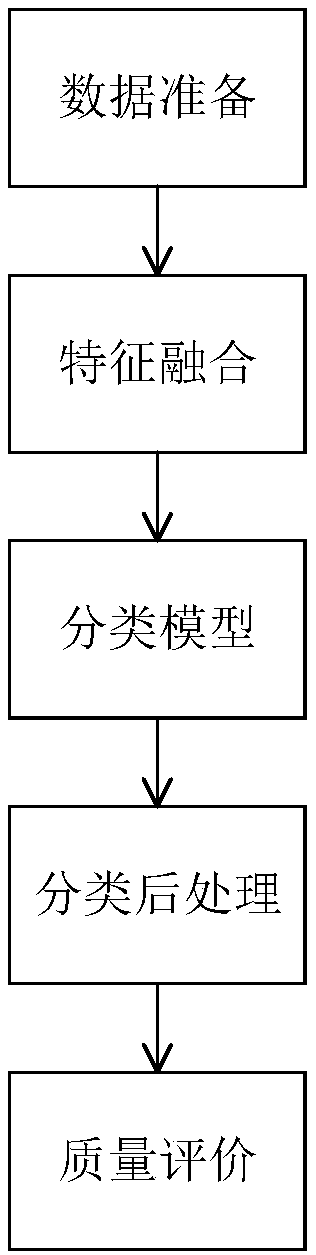
[0047] In order to better understand the technical solutions of the present invention, the present invention will be further described in detail below in conjunction with the accompanying drawings and embodiments.

[0048] Step 1, establish a parallel computing framework.

[0049] Step 1.1, data parallelism. Due to the large amount of high-resolution remote sensing image data, it is necessary to segment the high-resolution remote sensing image data before performing land cover classification. Data parallelism is to automatically divide the data according to a certain strategy before data calculation, and divide a large specification data into multiple small data modules, which are calculated by multiple CPU cores and other computing resources. In the future, the data will be automatically merged according to the principle of data segmentation, and the data in the required format will be returned. Data parallelism can be calculated with the following formula.

[0050] After a...


PUM


Abstract

The invention discloses a land cover classification method for a high-resolution remote sensing image based on a parallel algorithm. The method comprises the steps that S1, high-resolution remote sensing image data is segmented according to the number of computers, and high-resolution remote sensing image blocks after segmentation are obtained; S2, all the high-resolution remote sensing image blocks are allocated to m processors based on an OpenMP parallel framework, and land cover classification processing is executed concurrently; and S3, according to the data segmentation principle, all high-resolution remote sensing image block data is merged, and a final land cover classification result is obtained. Through the method, the data is automatically segmented according to the data size andcomputer memory using conditions, a configuration file is used to organize a classification algorithm process, a parallel classification algorithm is realized, and therefore the method can adapt to ahigh-resolution land cover charting task with an extremely large data volume and land object space fine division.

Description

technical field [0001] The invention belongs to the technical field of remote sensing image processing, in particular to a land cover classification method for high-resolution remote sensing images based on parallel algorithms. Background technique [0002] Land resources are related to the social and economic construction of the country and are the basis for human survival. With the development of urbanization, it is necessary to determine the land cover / utilization that reflects the natural and social attributes of land surface features, which is important for the earth system model, global Environmental changes, land protection, urban development decisions, and water conservancy project construction all play an important role. For this reason, in the past few decades, the international community and various organizations have attached great importance to the research on land cover / utilization and its changes, and research projects have emerged frequently, such as the Inte...

Claims


Application Information

Patent Timeline
Patent Type & Authority Applications(China)
IPC IPC(8): G06K9/00G06K9/62G06T7/187
CPCG06T7/187G06T2207/10032G06T2207/30184G06V20/13G06F18/2411G06F18/2415
Inventor 钟燕飞赵济吕鹏远王晶马爱龙刘艳飞伍丝琪张良培
Owner WUHAN UNIV
Why Eureka
Try Eureka