Drone positioning method and drone positioning system for flight verification

A positioning method and positioning system technology, which are applied in the field of UAV positioning methods and systems for flight verification, can solve problems such as the decline of positioning accuracy, and achieve the effects of reducing impact, improving safety, and stable and reliable positioning accuracy.

Inactive Publication Date: 2018-05-04
THE SECOND RES INST OF CIVIL AVIATION ADMINISTRATION OF CHINA
View PDF7 Cites 6 Cited by
  • Summary
  • Abstract
  • Description
  • Claims
  • Application Information

AI Technical Summary

Problems solved by technology

The existing UAVs that support the RTK differential positioning system can achieve centimeter-level positioning accuracy within 1

Method used


Image

  • Drone positioning method and drone positioning system for flight verification
  • Drone positioning method and drone positioning system for flight verification
  • Drone positioning method and drone positioning system for flight verification

Examples


Embodiment Construction

[0041]All features disclosed in this specification, or steps in all methods or processes disclosed, may be combined in any manner, except for mutually exclusive features and / or steps.

[0042] Any feature disclosed in this specification, unless specifically stated, can be replaced by other alternative features that are equivalent or have similar purposes. That is, unless expressly stated otherwise, each feature is one example only of a series of equivalent or similar features.

[0043] Related instructions:

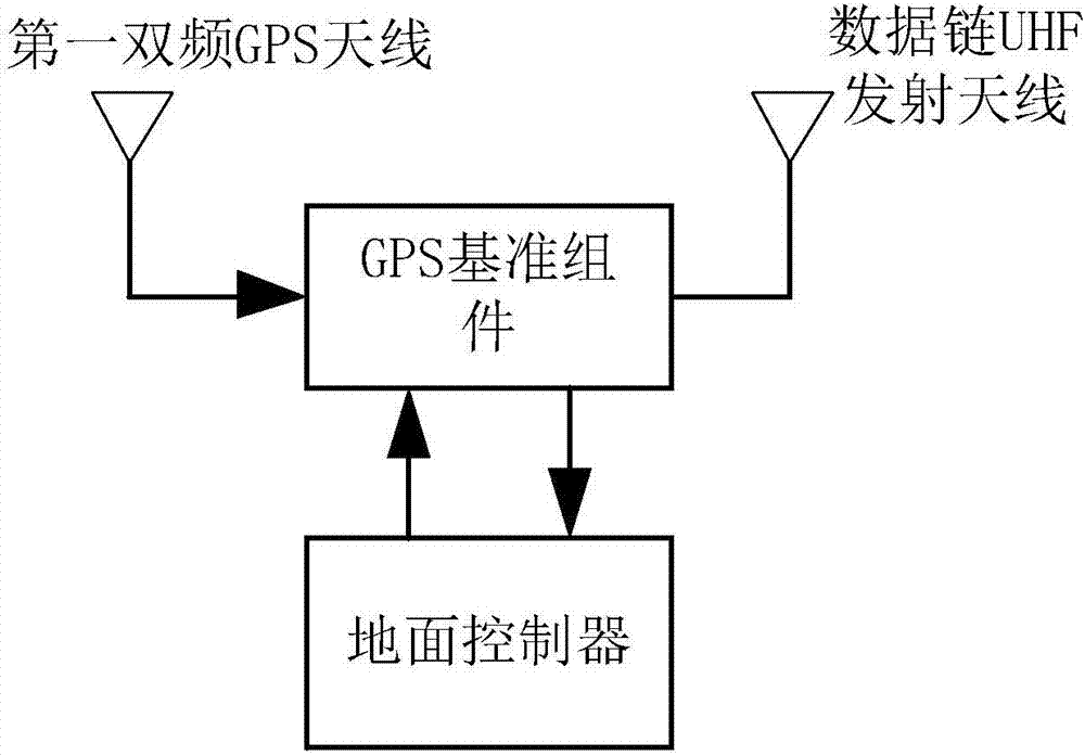
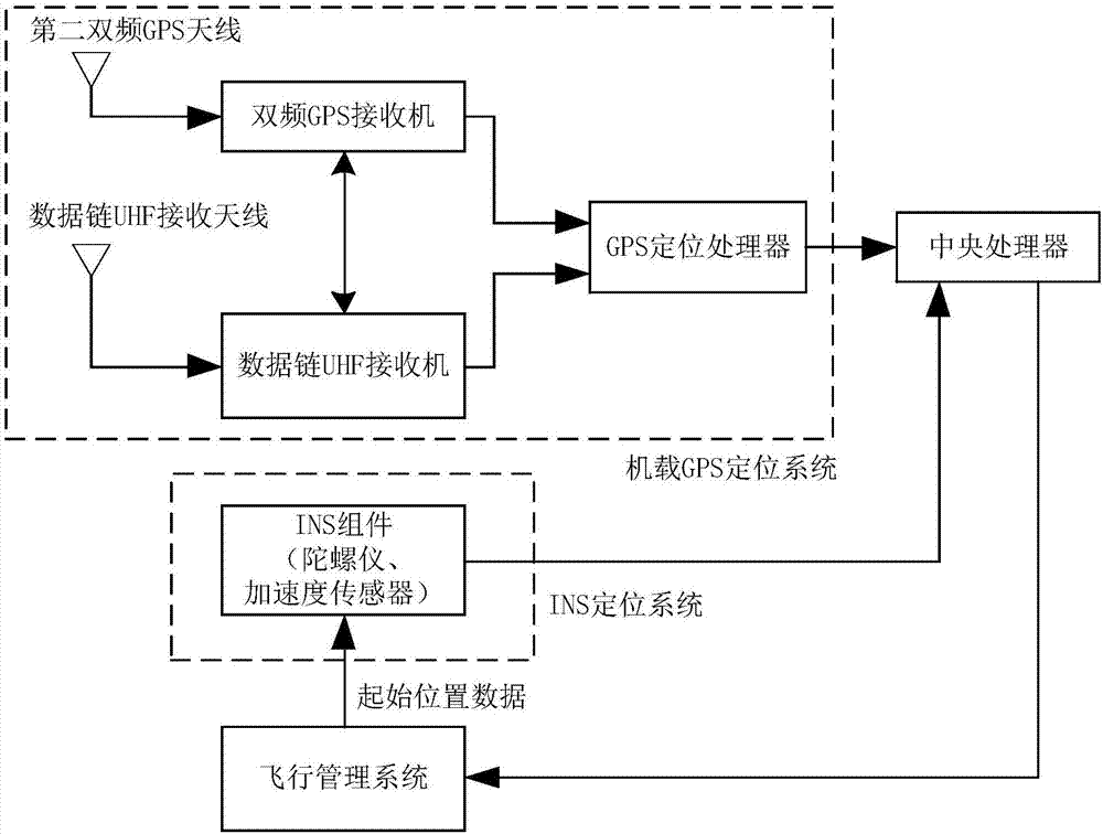
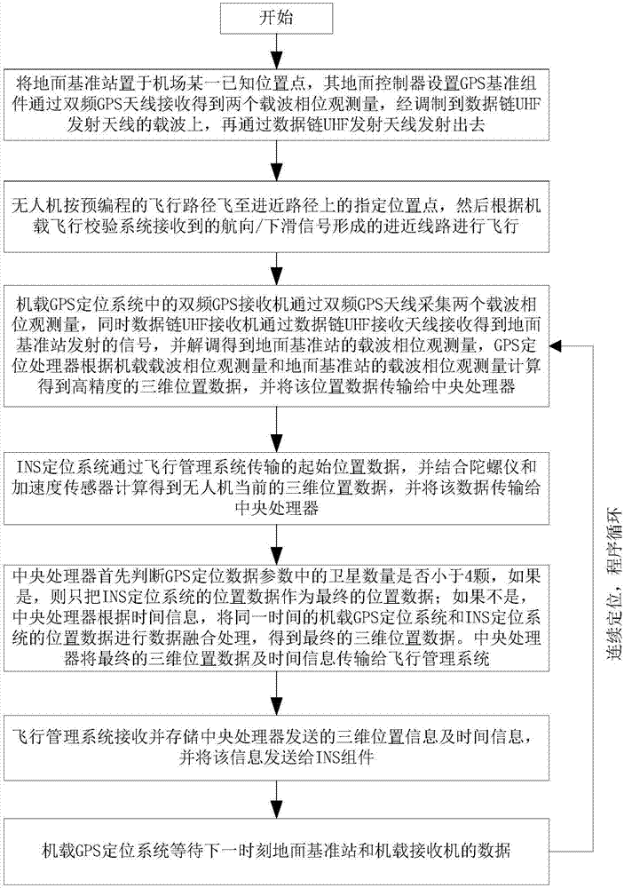
[0044] 1. UAV data link can be divided into uplink and downlink according to the transmission direction. The uplink mainly completes the sending and receiving of signals from the ground station to the remote control command of the UAV, and the downlink mainly completes the sending and receiving of signals such as telemetry data and infrared or TV images from the UAV to the ground station, and according to the positioning information The transmission uses the uplink and ...


PUM


Abstract

The invention relates to the field of civil aviation navigation equipment online monitor and flight verification for drones, in particular to a drone positioning method and a drone positioning systemfor flight verification. The drone positioning method includes according to reference carrier phase observation quantity of ground standard position information and position carrier phase observationquantity of drone flight routes at a same moment, acquiring three-dimensional drone position data at the moment by a GPS (global positioning system) on a drone; according to initial position information of the drone at a preceding moment, calculating the three-dimensional drone position data at the moment by an INS positioning system on the basis of data of a gyroscope, an acceleration sensor andthe like; by a central processor on the drone, according to the number of satellites involved in the three-dimensional drone position data of a GPS positioning processor at the moment, deciding whether to adopt the three-dimensional position data of the INS positioning system or the three-dimensional position data acquired after fusion of the INS positioning system and the GPS as the final three-dimensional drone position data to perform real-time positioning of the drone.

Description

technical field [0001] The invention relates to the field of on-line monitoring and flight verification of civil aviation navigation equipment of UAVs, in particular to a UAV positioning method and system for flight verification. Background technique [0002] At present, flight inspections at home and abroad are conducted by specialized flight inspection personnel who drive flight inspection aircraft equipped with special inspection equipment, and check and evaluate various navigation, radar, communication and other equipment in accordance with the relevant specifications of flight inspection. The quality of space signal and its tolerance, as well as the airport's incoming and outgoing flight procedures, and issue a flight inspection report based on the inspection and evaluation results. [0003] According to the provisions of the International Civil Aviation Organization (ICAO) and the Civil Aviation Administration of my country, it is mandatory to conduct flight inspection...

Claims


Application Information

Patent Timeline
IPC IPC(8): G01S19/23G01S19/47G01S19/44
CPCG01S19/235G01S19/44G01S19/47
Inventor 刘靖杨萍杨正波叶家全杨晓嘉
Owner THE SECOND RES INST OF CIVIL AVIATION ADMINISTRATION OF CHINA
Why Eureka
Try Eureka