Radio frequency identification locating method based on utilization of unmanned aerial vehicles

A technology of radio frequency identification positioning and drones, which is applied to computer components, collaborative operation devices, special data processing applications, etc., can solve the problems of accurate goods search, inability to accurately know the specific location of goods, low efficiency, etc., and achieve Avoid maintenance difficulties and improve cargo search efficiency

Active Publication Date: 2018-05-04
FOSHAN POLYTECHNIC
View PDF6 Cites 6 Cited by
  • Summary
  • Abstract
  • Description
  • Claims
  • Application Information

AI Technical Summary

Problems solved by technology

However, due to the large area of ​​the cargo yard (port, wharf, etc.), it is often necessary to find the specific location of the cargo corresponding to a certain ID number in practical applications. Although some readers may read this ID number, the microwave RFID The reading and writing distance can reach up to more than 300 meters, so the specific location of the goods cannot be accurately known, and it can only be proved that the goods are within a certain range, and this range is often very large, which brings great troubles to accurate goods search and efficiency. very low
[0003] Some researchers tried to install a GPS module in the active electronic tag, hoping that the active electronic tag would send back the GPS position information (latitude and longitude) by itself, but because the GPS module consumes a lot of power, the biggest defect of the active tag is precisely because of the power consumption. And maintenance is difficult, this method is not operable

Method used


Image

  • Radio frequency identification locating method based on utilization of unmanned aerial vehicles
  • Radio frequency identification locating method based on utilization of unmanned aerial vehicles
  • Radio frequency identification locating method based on utilization of unmanned aerial vehicles

Examples


Embodiment Construction

[0035] The technical solutions and beneficial effects of the present invention will be clearer and more definite by further describing the specific implementation manners of the present invention in conjunction with the accompanying drawings of the specification below. The embodiments described below by referring to the figures are exemplary for the purpose of explaining the present invention and should not be construed as limiting the present invention.

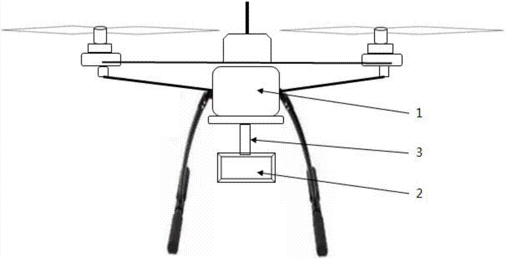
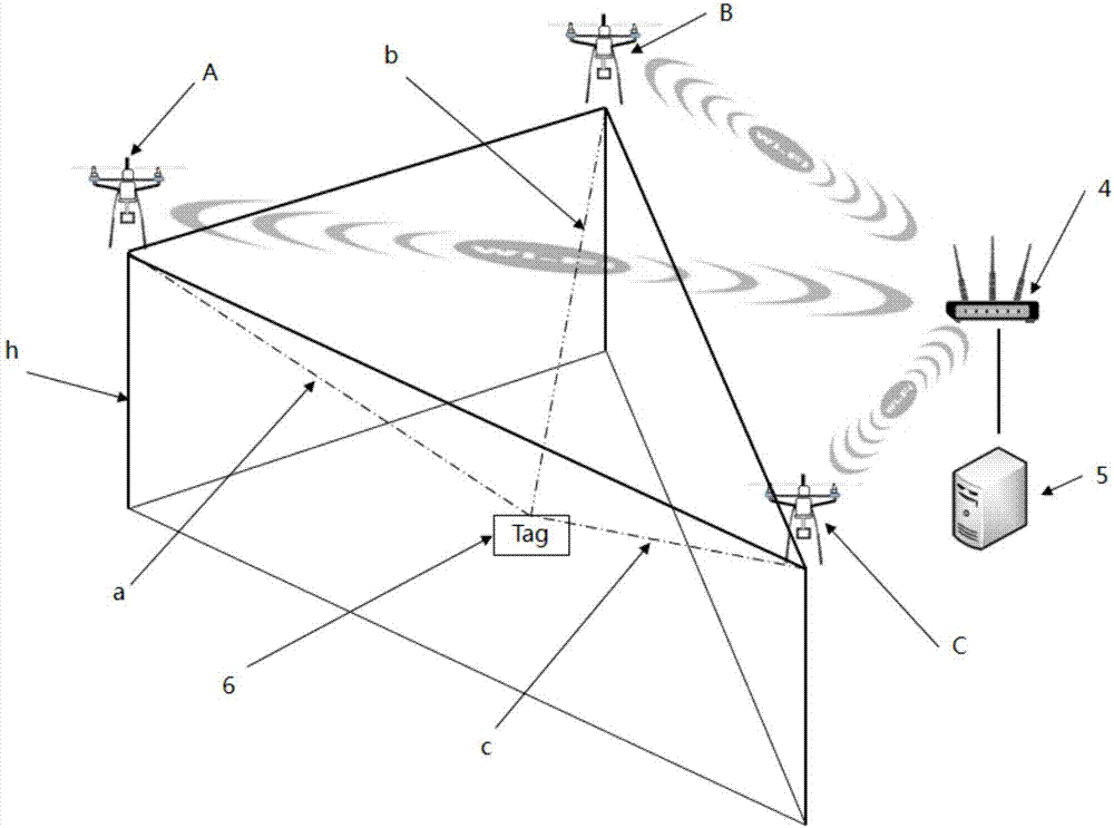
[0036] A radio frequency identification positioning method using drones, the principle of which is: prepare at least three drones, each of which is equipped with a microwave RFID reader with the same model parameters, and flies to the target from at least three different directions In the area where the goods may be stored, it is necessary to control the flight height of each drone to be basically the same. Once a drone reads the ID of the electronic tag of the target cargo, it immediately records the GPS data of the drone a...


PUM


Abstract

The invention discloses a radio frequency identification locating method based on utilization of unmanned aerial vehicles. The method is characterized by comprising the following steps that at least three unmanned aerial vehicles carrying FRID readers identical in type parameter are prepared, and the unmanned aerial vehicles fly from at least three different directions to a storage area of targetgoods, wherein the flight altitude of each unmanned aerial vehicle is equal; when one unmanned aerial vehicle reads the IDs of electronic labels of the target goods, the unmanned aerial vehicle immediately sends current longitude and latitude information to a server through a wireless network; when all unmanned aerial vehicles send back longitude and latitude information, the server calculates thelongitude and latitude of the target goods according to the longitude and latitude information; the server sends the longitude and latitude of the target goods to a mobile terminal, and the mobile terminal can quickly find out the goods through a navigation device. The locating deviation of the target goods is not greater than 5 m, great convenience is brought to searching of goods of a goods yard such as a port and a pier, only the unmanned aerial vehicles need to be maintained, and the problem that active tags are difficult to maintain can be completely avoided.

Description

technical field [0001] The invention relates to the technical field of signal positioning, in particular to a radio frequency identification positioning method using a drone. Background technique [0002] Active RFID electronic tags (2.4GHZ) in the microwave segment are widely used, and are mainly used in the management of vehicles and goods in large freight yards, such as container management in port terminals. Install active electronic tags (microwave electronic tags) on the objects to be managed, and deploy several readers at different intervals in large freight yards, so that the inflow and outflow of goods and vehicles can be managed automatically. However, due to the large area of ​​the cargo yard (port, wharf, etc.), it is often necessary to find the specific location of the cargo corresponding to a certain ID number in practical applications. Although some readers may read this ID number, the microwave RFID The reading and writing distance can reach up to more than ...

Claims


Application Information

Patent Timeline
IPC IPC(8): G06K17/00G06F17/30
CPCG06K17/0022G06F16/29
Inventor 肖志良黄润
Owner FOSHAN POLYTECHNIC
Why Eureka
Try Eureka