Method for indexing spatial data in cloud computing environment

A cloud computing environment, spatial data technology, applied in the direction of structured data retrieval, computing, database model, etc., can solve the problems of difficult expansion, high maintenance cost, performance bottleneck, etc., to save the search process, improve index performance, efficient effect of access

Active Publication Date: 2018-05-08
CHINA HIGHWAY ENG CONSULTING GRP CO LTD +1
View PDF9 Cites 7 Cited by
  • Summary
  • Abstract
  • Description
  • Claims
  • Application Information

AI Technical Summary

Problems solved by technology

[0003] However, traditional spatial data engines combined with large-scale relational database spatial data management methods have disadvantages such as low query efficiency, difficult expansion, and high maintenance costs, which cannot meet the needs of efficient access to massive spatial da

Method used


Image

  • Method for indexing spatial data in cloud computing environment
  • Method for indexing spatial data in cloud computing environment
  • Method for indexing spatial data in cloud computing environment

Examples


Embodiment Construction

[0053] The specific implementation of the present invention will be further described in detail below in conjunction with the accompanying drawings. The basic principles and definitions of some parameters are as described above, and will not be repeated here.

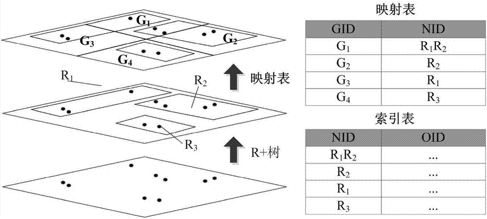
[0054] figure 1 It is a spatial index schematic diagram of the present invention, and the spatial data indexing method under the cloud computing environment proposed by the present invention, the specific steps are as follows:

[0055] 1) Create a data storage table based on spatial data:

[0056] Use the unique code value (OID, Object ID) of the spatial object as the row key of the storage table, and design two column clusters at the same time:

[0057] COLUMNFAMILY_GEO is used to store geometric information of spatial objects in the form of wkt;

[0058] COLUMNFAMILY_PRO is used to store spatial object attribute information, including length, area and title.

[0059] 2) Establish R+-tree index based on spatial obje...


PUM


Abstract

The invention discloses a method for indexing spatial data in a cloud computing environment. The method comprises the following steps of: 1) establishing a data storing table on the basis of the spatial data; 2) building an R+-tree index on the basis of spatial object distribution; 3) building a grid index on the basis of spatial object coverage range; 4) carrying out dimensionality reduction andcoding on the R+-tree index and the grid index by utilizing a Z curve; 5) establishing a code mapping table of R+- trees and grids; 6) establishing an index table on the basis of R+- tree codes and spatial objects ID; and 7) carrying out spatial range query. The method has the beneficial effects of making full use of the data organization characteristics of a NoSQL (Not Only Structured Query Language) database, optimizing the traditional spatial index and realizing the efficient access of the spatial data in the cloud environment.

Description

technical field [0001] The invention relates to the management field of spatial data, in particular to a method for constructing a spatial data index in a cloud computing environment. Background technique [0002] GIS is playing an increasingly important role in the development of modern cities. Spatial information has become an important part of the data source of digital city infrastructure construction. People need convenient and efficient spatial information service support in various aspects such as economy, transportation, politics and culture. At present, space data mainly comes from high-precision space sensors, satellites and GPS equipment, and the data is updated frequently and on a large scale. Due to the explosive growth of spatial data and the complex nature of geospatial models, spatial data operations often have high time complexity and consume a lot of computing resources. With the development of spatial information sharing services, the future integrated G...

Claims


Application Information

Patent Timeline
IPC IPC(8): G06F17/30
CPCG06F16/2246G06F16/28G06F16/29
Inventor 侯芸董元帅汪愿愿张艳红祝琳莹田春玲刘峰
Owner CHINA HIGHWAY ENG CONSULTING GRP CO LTD
Why Eureka
Try Eureka