Land leveling method based on GNSS

A technology for land leveling and earthwork volume, which is applied in land preparation methods, two-dimensional position/channel control, agricultural machinery and implements. Effect

Active Publication Date: 2018-05-11
CHINA AGRI UNIV
View PDF7 Cites 11 Cited by
  • Summary
  • Abstract
  • Description
  • Claims
  • Application Information

AI Technical Summary

Problems solved by technology

[0005] However, it is easy to have the problem of empty or full load of the shovel during the leveling operation.
Empty forklifts cause the system to have no soil to unload, and full loads cause the system to be in an ineffective working state where the system cannot dig soil. In this state, the terrain of the farmland that the tractor dr

Method used


Image

  • Land leveling method based on GNSS
  • Land leveling method based on GNSS
  • Land leveling method based on GNSS

Examples


Embodiment Construction

[0034] In order to make the purpose, technical solutions and advantages of the present invention clearer, the technical solutions in the present invention will be clearly and completely described below in conjunction with the accompanying drawings in the embodiments of the present invention. Obviously, the described embodiments are the embodiment of the present invention. Some, but not all, embodiments. Based on the embodiments of the present invention, all other embodiments obtained by persons of ordinary skill in the art without making creative efforts belong to the protection scope of the present invention.

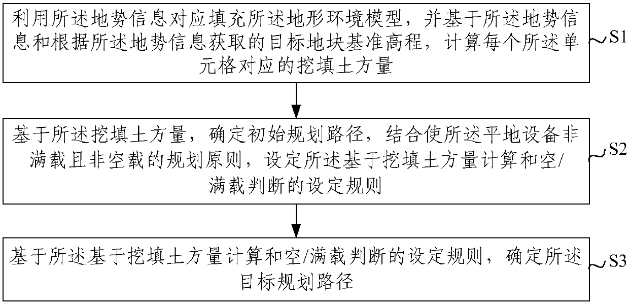
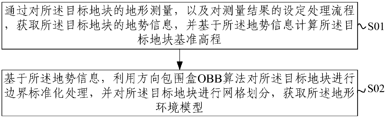
[0035] As an embodiment of the embodiment of the present invention, this embodiment provides a GNSS-based land leveling method, including: according to a predetermined target planning path, guiding the leveling equipment to perform the leveling operation of the target plot; wherein, the The target planning path is determined based on the terrain information of the targ...


PUM


Abstract

The invention provides a land leveling method based on GNSS (Global Navigation Satellite System). The method comprises the following steps: determining the general trend of a planned path through analyzing the terrain of the global planning of a target land parcel according to acquired terrain information and a terrain environment model of the target land parcel; then, carrying out local adjustment for avoiding the empty load and full load of ground leveling equipment through the calculation of excavation and filling earth volume based on the terrain environment model and the terrain information, namely, determining the target planned path of the traversing target parcel through the combination of the setting rule based on the calculation of the excavation and filling earth volume and thejudgment of empty/full load; and finally, guiding the ground leveling equipment to carry out target land parcel leveling operation according to the planned path. According to the method provided by the invention, through reasonable ground leveling path planning, the empty load, full load, repeated leveling and omissive leveling of the ground leveling equipment can be effectively avoided or reduced, the land leveling can be effectively guided, and thus the land leveling efficiency is improved.

Description

technical field [0001] The present invention relates to the technical field of farmland fine leveling in precision agriculture, and more specifically, to a GNSS-based land leveling method. Background technique [0002] Land leveling is an important link in land development and consolidation projects and agricultural water resources management. The original inclined and undulating ground is leveled into a level ground or a ground with a certain slope through equipment. Land leveling can effectively increase the effective arable land area, promote intensive use of land and large-scale management; it can facilitate mechanized farming, improve agricultural production conditions, and speed up the modernization process of agriculture; Water, improving soil quality, maintaining soil fertilizer, increasing production and income, and improving labor productivity play an important role. [0003] GNSS (Global Navigation Satellite System, GNSS) leveling technology obtains three-dimensi...

Claims


Application Information

Patent Timeline
IPC IPC(8): A01B79/00G05D1/02
Inventor 刘刚康熙夏友祥景云鹏
Owner CHINA AGRI UNIV
Why Eureka
Try Eureka