High-precision map generating system and method

A map generation, high-precision technology, applied in the directions of radio wave measurement systems, satellite radio beacon positioning systems, measurement devices, etc., can solve problems such as cost increase, and achieve the effect of saving costs and improving signal accuracy

Inactive Publication Date: 2018-05-15
HUAYU AUTOMOTIVE SYST
View PDF8 Cites 79 Cited by
  • Summary
  • Abstract
  • Description
  • Claims
  • Application Information

AI Technical Summary

Problems solved by technology

[0006] In the above methods, more sensors are used to improve the accuracy of the map, but the problem brought by multiple sensors is the increase in cost, especially the cost of lidar ranging from tens of thousands to hundreds of thousands

Method used


Image

  • High-precision map generating system and method
  • High-precision map generating system and method
  • High-precision map generating system and method

Examples


Embodiment Construction

[0039] Below in conjunction with the drawings, preferred embodiments of the present invention are given and described in detail.

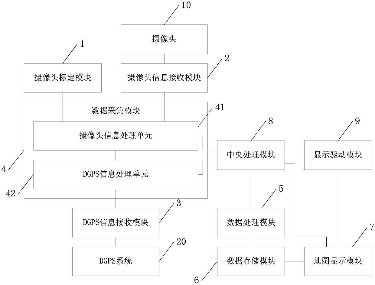
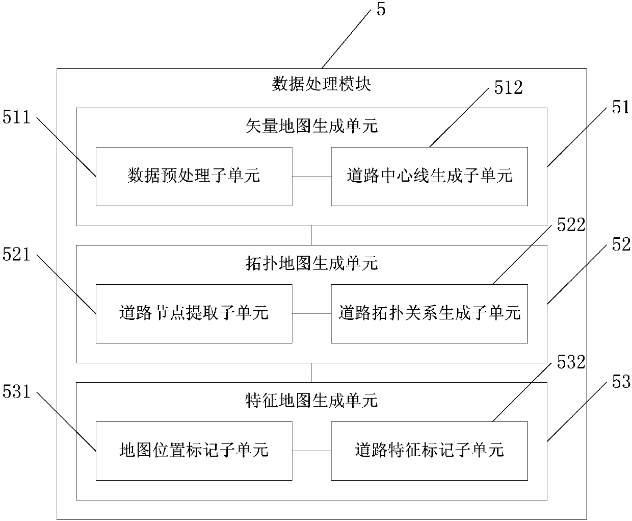
[0040] see figure 1 , 2 , one of the present invention, that is, a high-precision map generation system, comprising: camera calibration module 1, camera information receiving module 2, DGPS information receiving module 3, data acquisition module 4, data processing module 5, data storage module 6, Map display module 7, central processing module 8 and display driver module 9, wherein,

[0041] The camera calibration module 1 is connected with the data acquisition module 4, the camera 10 is connected with the data acquisition module 4 through the camera information receiving module 2, the DGPS system 20 is connected with the data acquisition module 4 through the DGPS information receiving module 3, and the data acquisition module 4 is connected with the central processing module 8 is connected with the data processing module 5, and the data processi...


PUM


Abstract

The invention relates to a high-precision map generating system and method, wherein the system comprises: a data acquisition module that acquires driving data of each trajectory point on a vehicle driving trajectory and plane xy coordinates on trajectory points on a road center line in accordance with vehicular DGPS (differential global positioning system) data provided by a DGPS and image data ofa scene in front of a vehicle provided by a camera; a data processing module connected with the data acquisition module and which generates the road center line according to the driving data of the trajectory points and the plane xy coordinates of the trajectory points on the road center line, and acquires structural information of a whole map by generating road topological relation according tothe road center line; and a map display module connected with the data processing module. By fusing image information acquired by the camera and the DGPS information, a high-precision map can be generated at low cost.

Description

technical field [0001] The invention relates to a high-precision map generation system and method for unmanned vehicles in parks. Background technique [0002] As we all know, in the research and development process of unmanned vehicles, it is necessary to draw maps for vehicle navigation. In the current existing technologies, the methods for generating maps mainly include the following: [0003] 1. The method disclosed in the patent document CN105579811A uses external images, inertial measurement units, wireless measurement technology GNSS (Global Navigation Satellite System, global satellite navigation system) and other non-wireless measurement sensor data fusion results to determine the user’s global location. The loop trajectory in the coordinates, combined with this trajectory and the image feature points applied with vSLAM (Visual simultaneous localization and mapping, visual real-time localization and map construction) technology, to obtain planar structure and (or) ...

Claims


Application Information

Patent Timeline
Patent Type & Authority Applications(China)
IPC IPC(8): G01C21/32G01C21/34G01S19/41G01S19/45
CPCG01C21/32G01C21/3415G01S19/41G01S19/45
Inventor 郭剑鹰陈华宇刘炳祥郑艳
Owner HUAYU AUTOMOTIVE SYST
Why Eureka
Try Eureka