A Multi-level Vector Road Network Matching Method Based on Delaunay Triangulation

A technology of triangulation and matching methods, applied in image analysis, image enhancement, instruments, etc., to achieve the effect of good matching relationship

Inactive Publication Date: 2020-06-26
CHINA UNIV OF GEOSCIENCES (WUHAN)
View PDF7 Cites 0 Cited by
  • Summary
  • Abstract
  • Description
  • Claims
  • Application Information

AI Technical Summary

Problems solved by technology

This method is limited by the map, and complex spatial road data must be at the same scale

Method used


Image

  • A Multi-level Vector Road Network Matching Method Based on Delaunay Triangulation
  • A Multi-level Vector Road Network Matching Method Based on Delaunay Triangulation
  • A Multi-level Vector Road Network Matching Method Based on Delaunay Triangulation

Examples


Embodiment 1

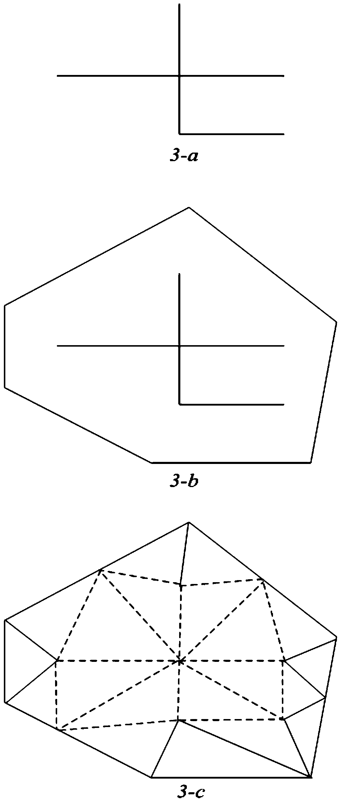
[0062] In order to illustrate the idea of ​​the present invention more clearly, below in conjunction with appendix image 3 A small road network data is used as an example for further illustration.

[0063] image 3 -a shows a simple road data with 3 roads.

[0064] Utilize the method of the present invention to carry out matching road:

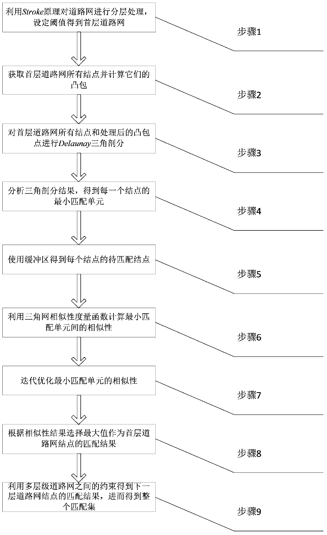
[0065] Step 1) Remove the roads where the nodes with a connectivity of 1 are located, and use the Stroke principle to process the road network hierarchically, and set the threshold to obtain the first-level road network.

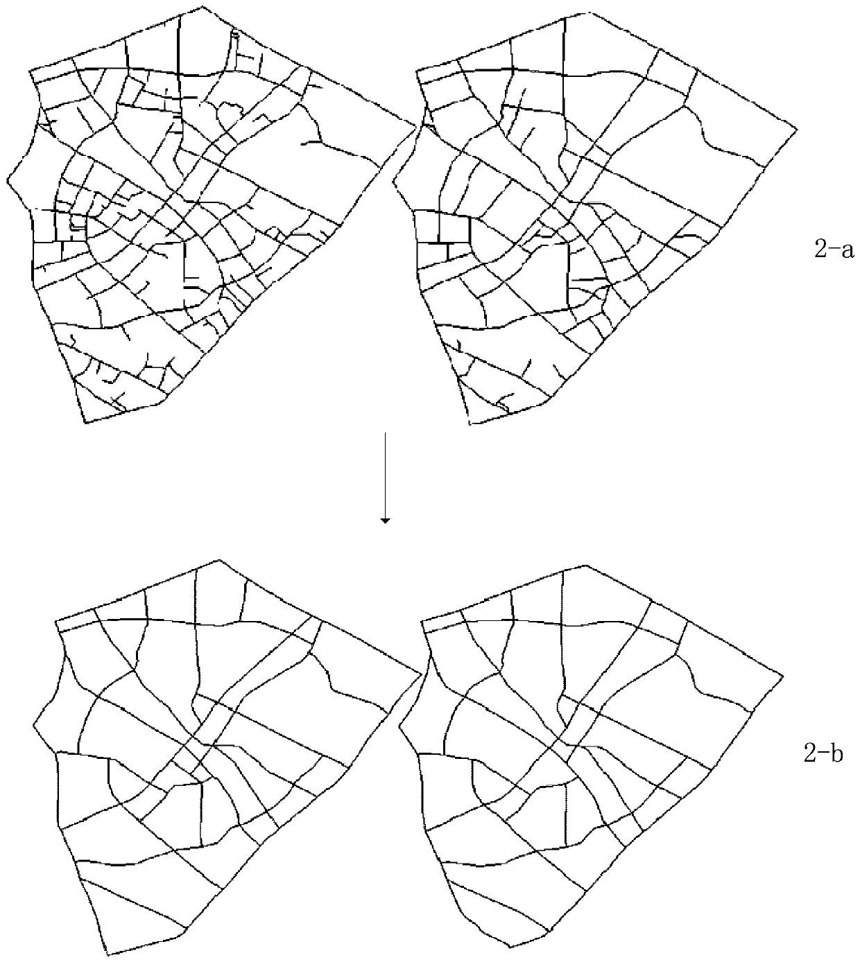
[0066] figure 2 -a is two pieces of road network data to be matched, figure 2 -b is the result of the first-level road network obtained after step 1.

[0067] Step 2) Obtain all the nodes of the road network, and then obtain their convex hull polygons, and then expand and refine the convex hull, so that the points on the obtained polygons are evenly distributed in the outer layer of the first layer of road network, s...


PUM


Abstract

The invention discloses a multi-layer vector road network matching method based on Delaunay triangulation. The method comprises the steps of utilizing the Stroke principle for performing layering processing on a road network, and setting a threshold value to obtain a first-layer road network; calculating convex hulls of all nodes in the road network, and processing the convex hulls; performing triangulation; obtaining the minimum matching unit of each node; utilizing a buffer region method for obtaining a node to be matched of each node; obtaining the similarity of the minimum matching unit ofthe corresponding node; performing iterative optimization on the similarity of the minimum matching units; selecting the node with the highest similarity of the minimum matching unit in the nodes tobe matched as the matched node; utilizing the constraint among different layer roads for calculating the matching relation of the next layer road nodes, and then obtaining the final matching set. Thegood vector road element matching relation can be obtained.

Description

technical field [0001] The invention relates to multi-source vector road data integration and fusion technology, in particular to a multi-level vector road network matching method based on Delaunay triangulation. Background technique [0002] Vector road network matching plays an important role in the field of map fusion, integration and update. To obtain the matching relationship between vector roads in different coordinate systems, it is necessary to solve the problems of rotation offset and scaling of road networks. Use the buffer growth method or iterative closest point method to find the matching features with the same name in a predetermined distance, and determine the matching points through the similarity measurement function, and only process vectors in the same geometric system (that is, the same coordinate system or a similar coordinate system) Data matching rarely deals with vector road data of different or even unknown coordinate systems. At the same time, the e...

Claims


Application Information

Patent Timeline
Patent Type & Authority Patents(China)
IPC IPC(8): G06T7/33
CPCG06T7/33G06T2207/30256
Inventor 杨林戴松岭左泽均王晋斌
Owner CHINA UNIV OF GEOSCIENCES (WUHAN)
Why Eureka
Try Eureka