Method for realizing landscape three-dimensional visualization based on drone

A drone and landscape technology, applied in the 3D field, can solve the problems of expensive equipment, inconvenient transportation and use, and difficult modeling, and achieve the effects of low cost of use, fast maneuvering, and low risk.

Inactive Publication Date: 2018-06-15
FUJIAN AGRI & FORESTRY UNIV
View PDF4 Cites 33 Cited by
  • Summary
  • Abstract
  • Description
  • Claims
  • Application Information

AI Technical Summary

Problems solved by technology

3D scanning equipment can reconstruct the 3D model of objects with high precision, but the equipment is exp

Method used


Image

  • Method for realizing landscape three-dimensional visualization based on drone
  • Method for realizing landscape three-dimensional visualization based on drone
  • Method for realizing landscape three-dimensional visualization based on drone

Examples


Embodiment Construction

[0029] The present invention will be further explained below in conjunction with the accompanying drawings and specific embodiments.

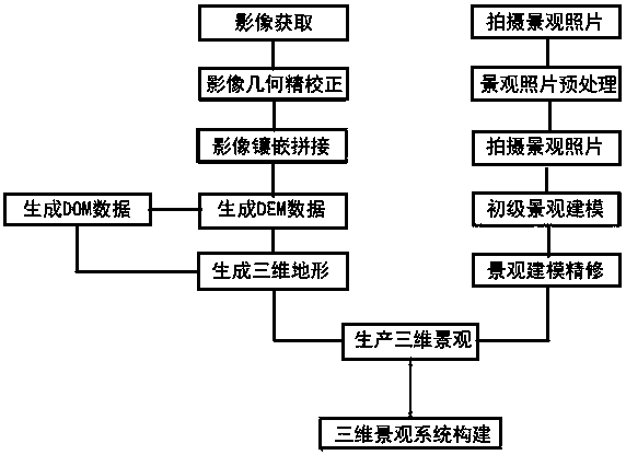
[0030] The present invention adopts the following technical solutions: a method for realizing three-dimensional visualization of landscape based on unmanned aerial vehicles, which includes the following steps: Step S1: acquiring images through an unmanned aerial vehicle remote sensing platform with a camera; using the relative flight height and the designed route for shooting, And set the overlapping degree of the image in the heading and side directions; Step S2: Remove cloud and fog processing for the acquired image data, and perform mosaic and cropping according to the size of the research area, perform geometric fine correction on the image, and perform a geometric fine correction on the corrected image. Resampling, used to identify landscape types; map the surface texture of the generated UAV image to the 3D model that has been pre-built to...


PUM


Abstract

The invention provides a method for realizing landscape three-dimensional visualization based on a drone. The method comprises S1: acquiring images through a UAV remote sensing platform with a camera,carrying out photographing through relative altitude and a design route and setting an image overlap degree along heading and side directions, S2, carrying out inlaying and cutting according to the research area size, carrying out geometrical fine correction on the images, re-sampling the corrected images for identifying the landscape type, and mapping terrain texture of the produced drone imagesto a preproduced 3D model to obtain a simulative 3D surface model, S3, building a landscape model, and S4, overlaying spatial data of the 3D surface landscape and 3D objects on the ground to obtain 3D landscape in a study area and building 3D query and analysis functions according to the landscape cases of the study area. The method can acquire the remote sensing images with high resolution and improve the accuracy of 3D construction of the landscape.

Description

technical field [0001] The invention belongs to the field of 3D technology, and in particular relates to a method for realizing three-dimensional visualization of a landscape based on an unmanned aerial vehicle. Background technique [0002] With the continuous development of the information age, more and more applications require 3D scene models. At the same time, with the continuous development of information technology such as computer technology and the continuous popularization of various digital devices, the research on establishing 3D models of certain scenes or objects in the real world has gradually attracted the attention of researchers. 3D reconstruction has been widely used in architecture, gardens, virtual reality and other fields and has a very broad application prospect in the future. [0003] The methods of obtaining 3D models can be divided into three categories: first, directly use mathematical models or geometric modeling techniques to build models; secon...

Claims


Application Information

Patent Timeline
IPC IPC(8): G01C11/00G01C11/04H04N13/204H04N13/275H04N13/106H04N13/15G06T5/00G06T7/55G06T17/05
CPCG01C11/00G01C11/04G06T5/003G06T17/05G06T2207/10016G06T2207/30181G06T7/55
Inventor 肖以恒谢雨纾卓志雄林娜张华荣朱晓玥朱里莹黄启堂
Owner FUJIAN AGRI & FORESTRY UNIV
Why Eureka
Try Eureka