Vehicle positioning method

A vehicle positioning and vehicle technology, applied in directions such as road network navigators, can solve problems such as low matching accuracy between frames

Active Publication Date: 2018-06-29
FAFA AUTOMOBILE (CHINA) CO LTD
View PDF6 Cites 17 Cited by
  • Summary
  • Abstract
  • Description
  • Claims
  • Application Information

AI Technical Summary

Problems solved by technology

[0004] However, the inventor found in the process of realizing the invention that the core of the algorithm in the prior art is to use frame-to-frame matching (Registration), and laser devices with lower resolution (s

Method used


Image

  • Vehicle positioning method
  • Vehicle positioning method
  • Vehicle positioning method

Examples


Example Embodiment

[0089] Embodiment one

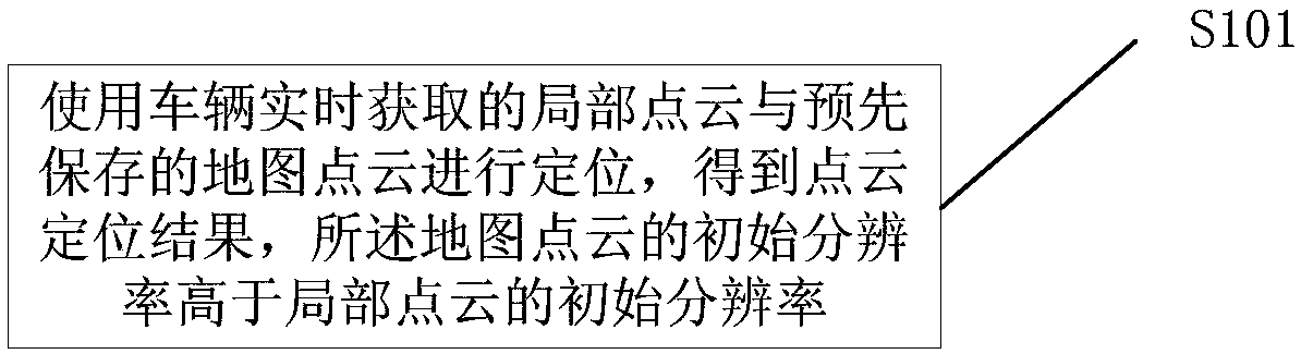
[0090] like figure 1 Shown is a work flow chart of a vehicle positioning method provided by an embodiment of the present invention, including:

[0091] Step S101, use the local point cloud acquired by the vehicle in real time and the pre-saved map point cloud for positioning to obtain a point cloud positioning result, the initial resolution of the map point cloud is higher than the initial resolution of the local point cloud.

[0092] Among them, the map point cloud is a high-precision map, which can be obtained online by a high-resolution laser device, and then provided by offline high-precision matching (for example, using the General-ICP method that is time-consuming but can achieve higher precision than the ICP method).

[0093] Then use the high-precision map point cloud as cloud data for multiple low-precision laser automatic driving systems to use at the same time. The vehicle with the automatic driving system performs step S101, and can obtain ...

Example Embodiment

[0095] Embodiment two

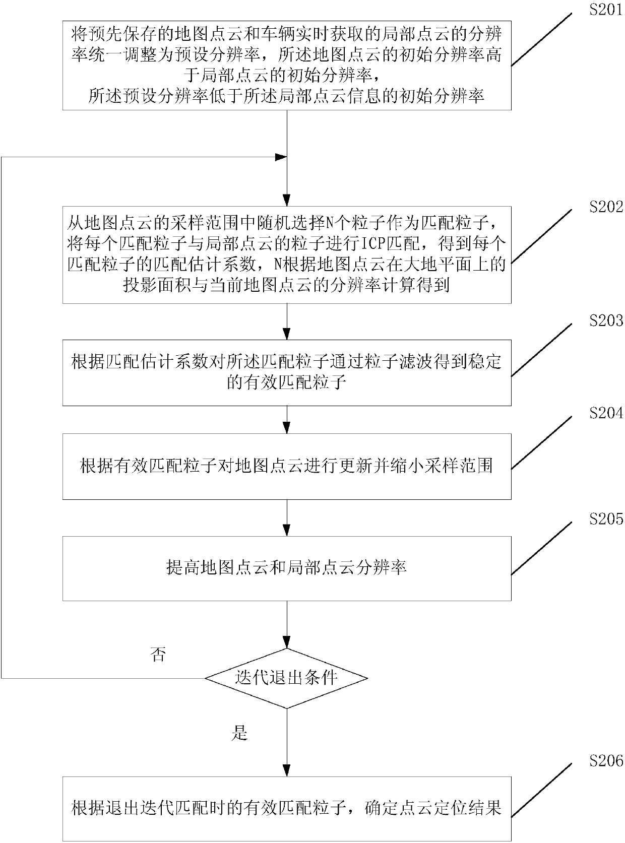
[0096] like figure 2 Shown is a work flow diagram of a vehicle positioning method provided by an optional embodiment of the present invention, including:

[0097] Step S201, the resolution of the pre-saved map point cloud and the local point cloud acquired by the vehicle in real time is uniformly adjusted to a preset resolution, the initial resolution of the map point cloud is higher than the initial resolution of the local point cloud, and the The preset resolution is lower than the initial resolution of the local point cloud information;

[0098] Specifically, the pre-saved map point cloud is converted into an octree structure to obtain a map octree structure, and the local point cloud acquired by the vehicle in real time is converted into an octree structure to obtain a local octree structure;

[0099] Adjust the map octree structure and local octree structure to the level corresponding to the preset resolution.

[0100] The octree is a hierarchi...

Example Embodiment

[0126] Embodiment three

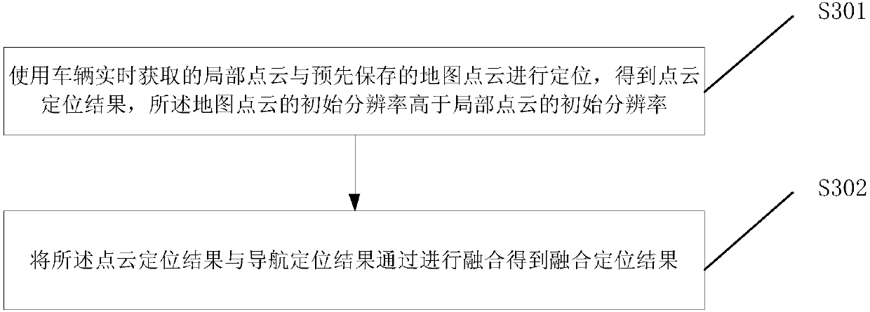
[0127] like image 3 Shown is a work flow diagram of a vehicle positioning method provided by another optional embodiment of the present invention, including:

[0128] Step S301, using the local point cloud acquired by the vehicle in real time and the pre-saved map point cloud for positioning to obtain a point cloud positioning result, the initial resolution of the map point cloud is higher than the initial resolution of the local point cloud.

[0129] In step S302, the point cloud positioning result and the navigation positioning result are fused to obtain a fusion positioning result.

[0130] Specifically, the point cloud positioning result and the navigation positioning result are fused through an extended Kalman filter to obtain a fused positioning result.

[0131] Since the stable release frequency of laser equipment is generally 10 Hz, the multi-resolution positioning release result in step S301 can only reach 10 Hz at most, while the environm...


PUM


Abstract

The embodiment of the invention discloses a vehicle positioning method. The vehicle positioning method comprises the following steps: positioning by using local point cloud acquired by a vehicle in real time and map point cloud saved in advance to obtain a point cloud positioning result, wherein the initial resolution ratio of the map point cloud is higher than the initial resolution ratio of thelocal point cloud. According to the embodiment of the invention, positioning is conducted by using local point cloud acquired by the vehicle in real time and the map point cloud saved in advance to obtain the point cloud positioning result, and the initial resolution ratio of the map point cloud is higher than the initial resolution ratio of the local point cloud. According to the embodiment of the invention, local point cloud can be acquired through laser equipment with low resolution ratio and is subjected to matched positioning with a high-precision map, so that the necessity of the high-precision laser equipment on the positioning problem is avoided and the positioning cost is reduced.

Description

technical field [0001] The invention relates to the technical field related to automobiles, in particular to a vehicle positioning method. Background technique [0002] With the development of autonomous driving, the automatic driving system gradually enters people's daily life from the experimental products in the laboratory. new question. Among them, problems such as towering buildings and magnetic field influence in the urban environment make the positioning algorithm relying on GPS positioning unable to provide stable and accurate positioning results. [0003] To solve this problem, the existing technology uses an online optimization estimation algorithm based on visual odometry (ORB_SLAM, LSD_SLAM). However, this method is heavily dependent on lighting conditions and cannot ensure long-term positioning estimation. Therefore, the prior art proposes a fusion positioning method based on laser odometry (LOAM) and visual laser odometry (V-LOAM), and maintains the state-of-...

Claims


Application Information

Patent Timeline
IPC IPC(8): G01C21/30
CPCG01C21/30
Inventor 殷鹏
Owner FAFA AUTOMOBILE (CHINA) CO LTD
Why Eureka
Try Eureka