Cloud-platform-based territorial resource data management system

A technology of land and resources and cloud platform, applied in the field of cloud computing, can solve problems affecting the application efficiency of land and resources data, poor reliability and maintainability of GIS software systems, etc.

Inactive Publication Date: 2018-06-29
BEIJING GREATMAP TECH
View PDF3 Cites 13 Cited by
  • Summary
  • Abstract
  • Description
  • Claims
  • Application Information

AI Technical Summary

Problems solved by technology

The traditional GIS model lacks the guidance of object-oriented cognitive methodology and object-oriented programming methodology in the process of GIS design and implementation, resulting in poor reliability and maintainability of GIS software systems; GIS, which

Method used


Image

  • Cloud-platform-based territorial resource data management system
  • Cloud-platform-based territorial resource data management system
  • Cloud-platform-based territorial resource data management system

Examples


Embodiment Construction

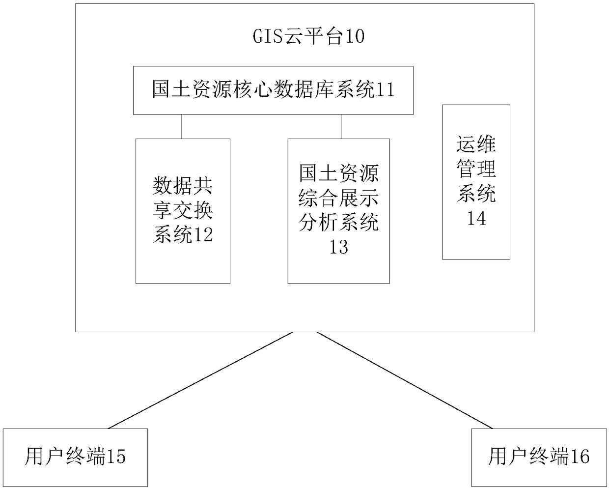
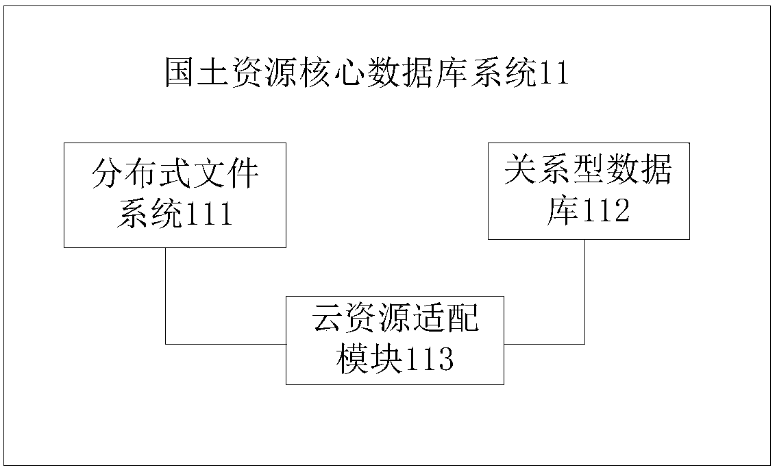
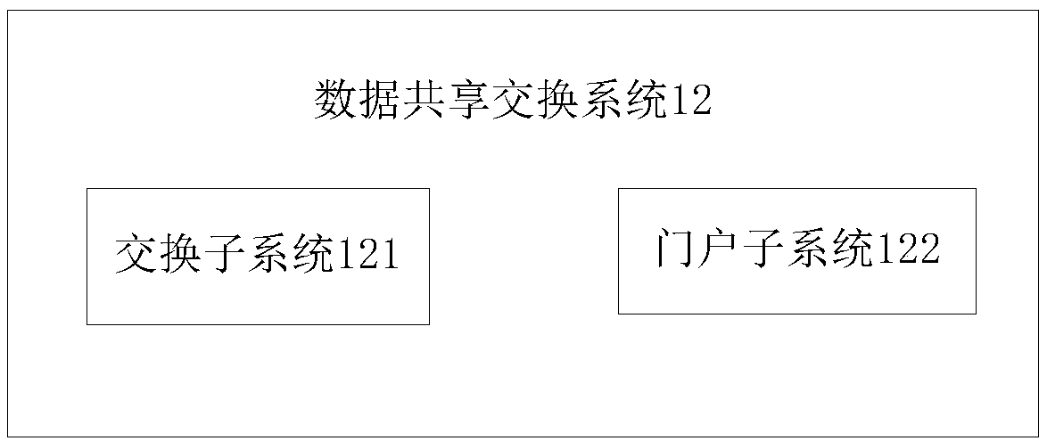
[0023] Various exemplary embodiments of the present invention will now be described in detail with reference to the accompanying drawings. It should be noted that the relative arrangements of components and steps, numerical expressions and numerical values ​​set forth in these embodiments do not limit the scope of the present invention unless specifically stated otherwise.

[0024] At the same time, it should be understood that, for the convenience of description, the sizes of the various parts shown in the drawings are not drawn according to the actual proportional relationship.

[0025] The following description of at least one exemplary embodiment is merely illustrative in nature and in no way taken as limiting the invention, its application or uses.

[0026] Techniques, methods and devices known to those of ordinary skill in the relevant art may not be discussed in detail, but where appropriate, techniques, methods and devices should be considered part of the description. ...


PUM


Abstract

The invention discloses a cloud-platform-based territorial resource data management system, comprising: a GIS (geographic information system) cloud platform that includes a territorial resource core database system, a data sharing-exchanging system, a territorial resource integrated display and analysis system and an operation maintenance and management system. The territorial resource core database system is used for storing and managing territorial resource data. The data sharing-exchanging system is used for generating territorial resource integrated data and providing an access interface for users. The territorial resource integrated display and analysis system is used for analyzing territorial resource data, generating analysis results, and providing an access interface for users. Theoperation maintenance and management system is used for performing rights management, monitoring, and resource scheduling. The cloud-platform-based territorial resource data management system can provide uniform establishment and sharing of hardware resources, thereby avoiding repeated investment; a uniform regular efficient data management function is provided; the data sharing problem is solved, business departments can assist in establishment and management of a decision model and in the sharing of decision plans.

Description

technical field [0001] The invention relates to the technical field of cloud computing, in particular to a cloud platform-based land resources data management system. Background technique [0002] Geospatial data is a subject-oriented, integrated, dynamically updated, and persistent spatial data collection with geographic coordinates, which expresses the spatial characteristics of geographic entities as geometric (positioning) features (location, shape, location, etc.) of geographic entities. size and its distribution characteristics) and the spatial relationship between entities. In recent years, the state has carried out basic survey work on land and resources, such as the second land survey, delineation of basic farmland, confirmation and registration of rural collective land rights, survey of rural homesteads, and verification of mining rights. Examination and approval business processes generate a large amount of data, which is the basis for the daily management of lan...

Claims


Application Information

Patent Timeline
IPC IPC(8): G06F17/30
CPCG06F16/182G06F16/248G06F16/25G06F16/284G06F16/29
Inventor 陈阳羽魏强余文富樊文有
Owner BEIJING GREATMAP TECH
Why Eureka
Try Eureka