Method and device for analyzing spatial position information from two-dimensional image

A technology of spatial position information and two-dimensional images, applied in image analysis, image data processing, graphics and image conversion, etc., can solve the problems of reduced computing efficiency, low computing efficiency and high computing cost, and achieve ultra-fast positioning measurement and analysis, High degree of automation, efficient calculation and refinement

Inactive Publication Date: 2018-08-14
QINGDAO ARJIUN OPTICAL TECH CO LTD
View PDF3 Cites 0 Cited by
  • Summary
  • Abstract
  • Description
  • Claims
  • Application Information

AI Technical Summary

Problems solved by technology

In doing so, all pixel units need to be transformed, and all two-dimensional image information on the image is converted into spatial position information. The calculation cost is high, the automation intervention is difficult, and the calculation efficiency is low.
More importantly, for some application scenarios with strict timeliness requirements, this method is very likely to make the spatial position information calculated by conversion lose its usefulness due to delay. Some requirements are high-precision. In order to improve Increasing the pixel accuracy will greatly increase the calculation cost and automation difficulty, and the calculation efficiency will further decrease, and the disadvantages of low timeliness will become more obvious.

Method used


Image

  • Method and device for analyzing spatial position information from two-dimensional image
  • Method and device for analyzing spatial position information from two-dimensional image
  • Method and device for analyzing spatial position information from two-dimensional image

Examples


Embodiment 1

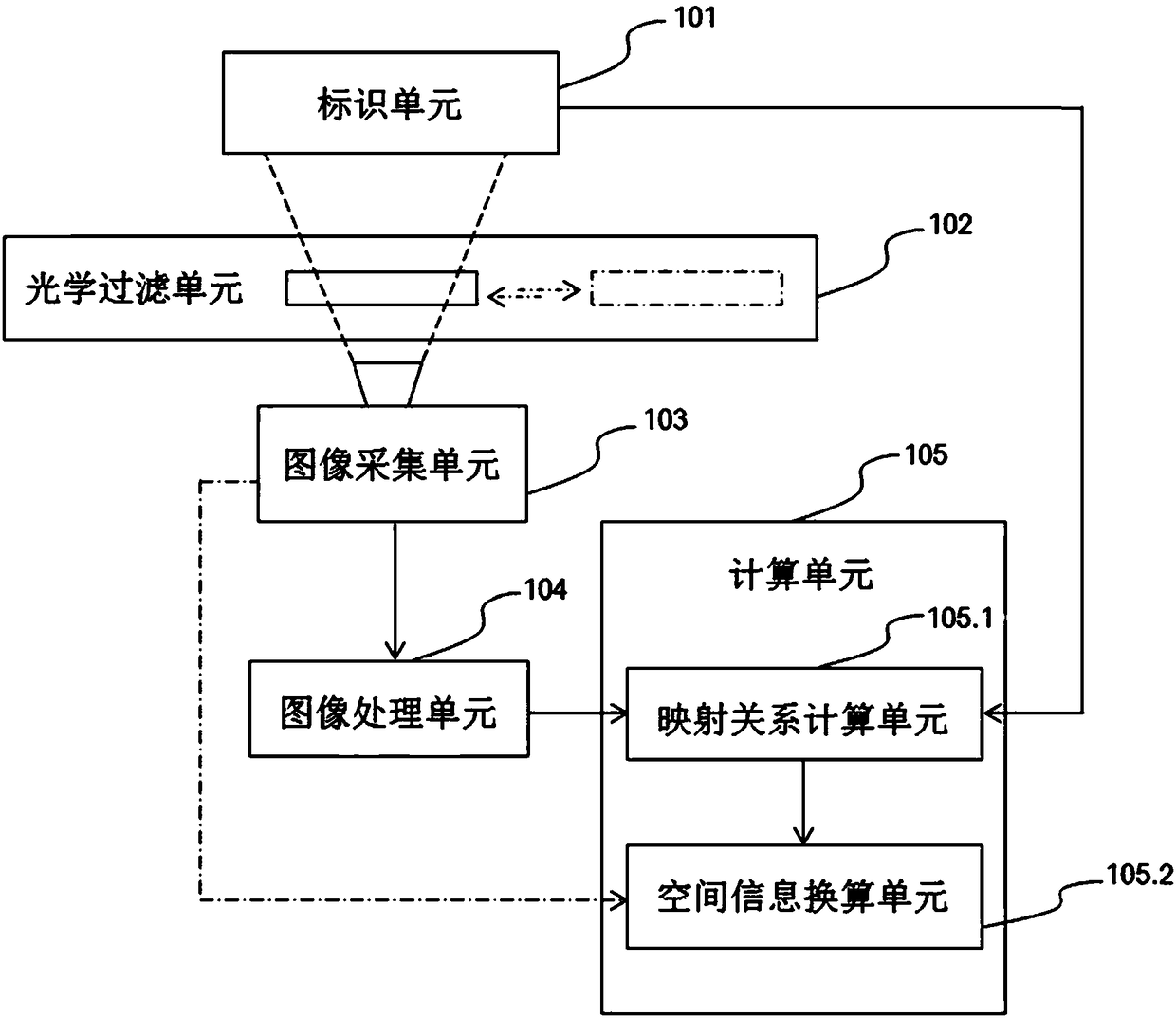
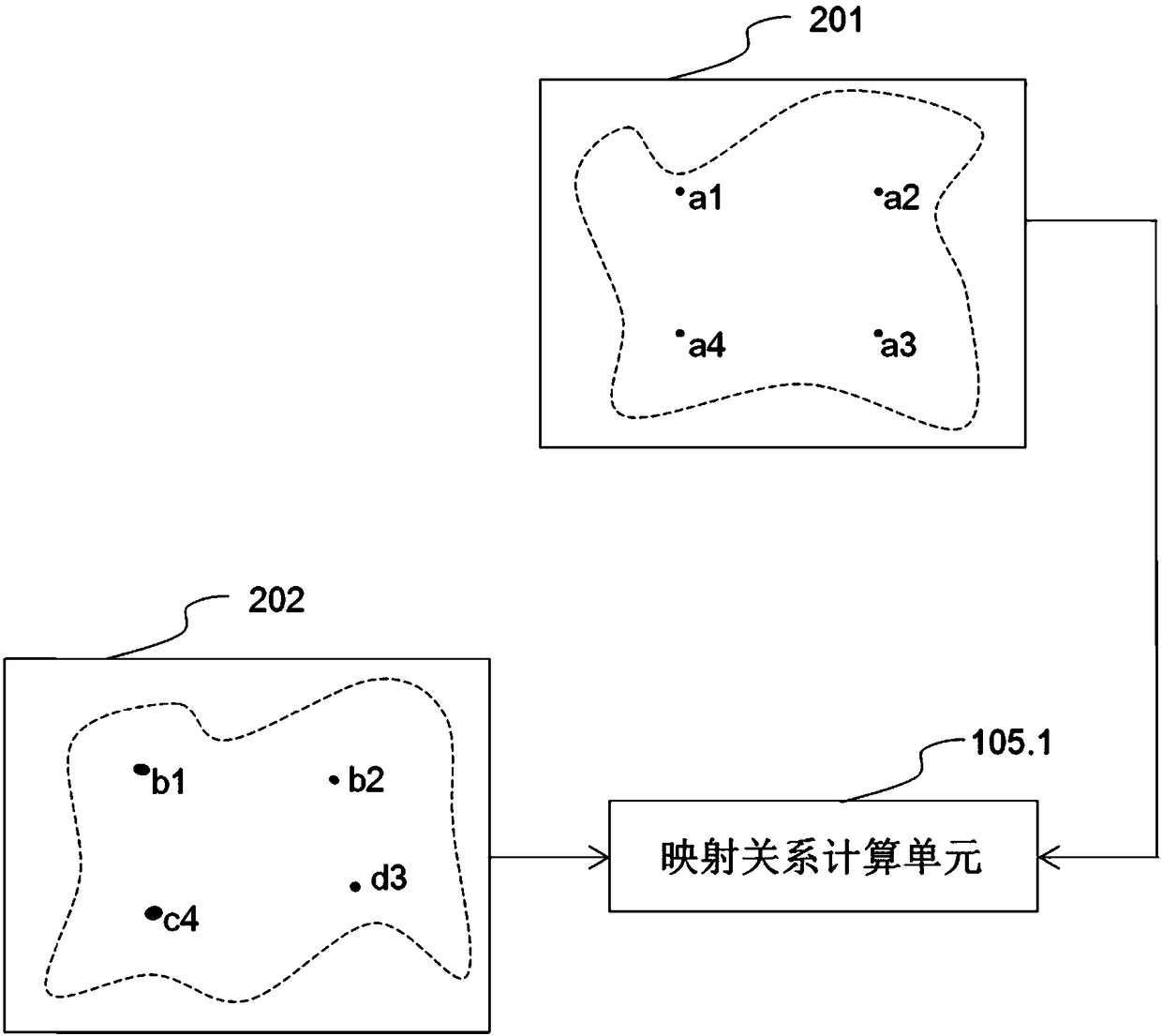
[0029] A device for analyzing spatial information from a two-dimensional image includes an identification unit 101, an optical filter unit 102, an image acquisition unit 103, an image processing unit 104, and a calculation unit 105, and the calculation unit 105 includes a mapping relationship calculation unit 105.1 and a spatial information conversion unit 105.2 . The mapping relationship calculation unit 105.1 calculates the mathematical mapping relationship between the two-dimensional image information and the spatial position information, and the spatial information conversion unit 105.2 calculates the spatial position information corresponding to the object on the two-dimensional image.

[0030] The identification unit 101 records and stores the spatial position information of the set identification, and supplies it to the mapping relationship calculation unit 105.1 in the calculation unit 105.

[0031] The marks provided on the mark unit 101 have one or more characteristi...

Embodiment 2

[0035] This embodiment is only different from Embodiment 1 in the following aspects, and the other parts are the same, and will not be repeated here.

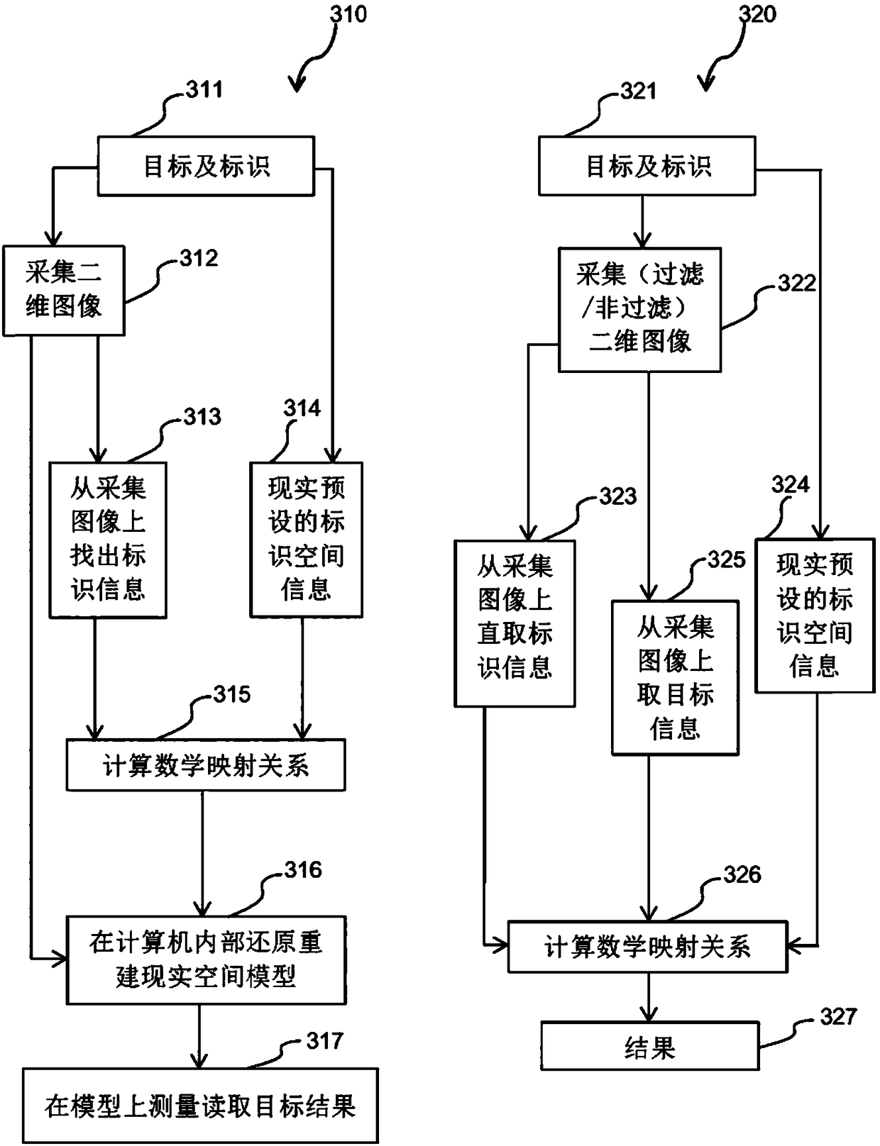
[0036] If it is not known in advance that the target is imaged at a certain position in the two-dimensional image, the image acquisition unit 103 is required to acquire an image containing all the information of the target at the same position. Generally, the optical filter unit 102 is separated within a short time before and after the filtered image is acquired, and the acquired The filtered image is used to assist in finding the target point, determine the position information of the target through corner detection, contour detection, etc. or software methods, and then combine the mathematical mapping relationship obtained by the mapping relationship calculation unit 105.1 to process the target through the spatial information conversion unit 105.2 spatial information.

[0037] Using fully automated means to determine the accura...

Embodiment 3

[0039] This embodiment is only different from Embodiment 1 in the following aspects, and the other parts are the same, and will not be repeated here.

[0040] This embodiment does not include the optical filter unit 102, and the image acquisition unit 103 collects images containing all information of the target end, identifies the logo through corner detection, contour detection, etc. in graphics processing technology or software methods, and obtains the logo on the two-dimensional image The clear two-dimensional information of is delivered to the computing unit 105.


PUM


Abstract

The invention belongs to the technical field of positioning measurement, and discloses a method and a device for analyzing spatial position information from a two-dimensional image. Identification isarranged on a target side, the reality spatial information of the identification is recorded and stored, an identification image is collected, the collected two-dimensional image information of the identification is combined with the spatial position information, a mathematical mapping relationship between the two-dimensional image information and the spatial position information is obtained, theposition information of a target on the two-dimensional image is determined, and the spatial information of the target on the two-dimensional image is converted through the mathematical mapping relationship between the two-dimensional image information and the spatial position information. By use of the method and the device, the spatial information can be positioned, measured and analyzed at highaccuracy, low cost and ultra high speed.

Description

technical field [0001] The invention relates to positioning measurement technology, in particular to a method and device for analyzing spatial position information from a two-dimensional image. Background technique [0002] The positional relationship of objects in the image collected by the image acquisition device may be different from that in the real space. For example, two objects in space are in a vertical relationship. If you take a photo of them, the two may no longer appear on the two-dimensional image. Then there is the vertical relationship. Analyzing the spatial position information from the two-dimensional image means that the two-dimensional image acquired by the image acquisition device locates the spatial position information of the measurement and analysis target. [0003] The existing technology for analyzing spatial position information from two-dimensional images mainly uses the knowledge of image transformation, collects images with image acquisition eq...

Claims


Application Information

Patent Timeline
Patent Type & Authority Applications(China)
IPC IPC(8): G06T7/70G06T3/00
CPCG06T3/005G06T3/00G06T7/70
Inventor 高俊
Owner QINGDAO ARJIUN OPTICAL TECH CO LTD
Why Eureka
Try Eureka