Microwave radar ranging method, microwave radar, computer storage medium, unmanned aerial vehicle and control method thereof

A technology of unmanned aerial vehicles and computer storage, which is applied in the directions of unmanned aerial vehicles, aerial vehicles, electromagnetic wave reradiation, etc. It can solve the problems of low efficiency of agricultural spraying operations, inability to obtain the relative altitude of the aircraft, and inability to measure the height of the landform in front, etc. problem, achieve the effect of ensuring safety and reliability and improving practicability

Inactive Publication Date: 2018-09-11
SZ DJI TECH CO LTD
View PDF8 Cites 17 Cited by
  • Summary
  • Abstract
  • Description
  • Claims
  • Application Information

AI Technical Summary

Problems solved by technology

[0004] However, in the process of implementing this technical solution, it was found that the method of obtaining flight altitude in the prior art has the following defects: the use of barometer or GPS in the prior art can only obtain the absolute height of the UAV relative to sea level, but cannot obtain The relative height of the aircraft relative to the ground cannot measure the undulating height of the front landform when the agricultural drone is operating, which will cause the efficiency of agricultural spraying operations to be relatively low during the agricultural drone operation; and if the ranging sensor is installed directly below , it cannot provide the relative carrier height information of the front and rear for the agricultural UAV, and thus cannot guarantee the safety and reliability of the agricultural UAV operation.

Method used


Image

  • Microwave radar ranging method, microwave radar, computer storage medium, unmanned aerial vehicle and control method thereof
  • Microwave radar ranging method, microwave radar, computer storage medium, unmanned aerial vehicle and control method thereof
  • Microwave radar ranging method, microwave radar, computer storage medium, unmanned aerial vehicle and control method thereof

Examples


Embodiment Construction

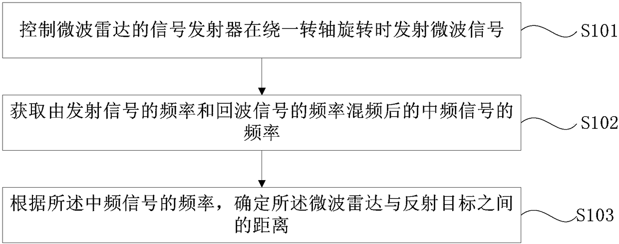
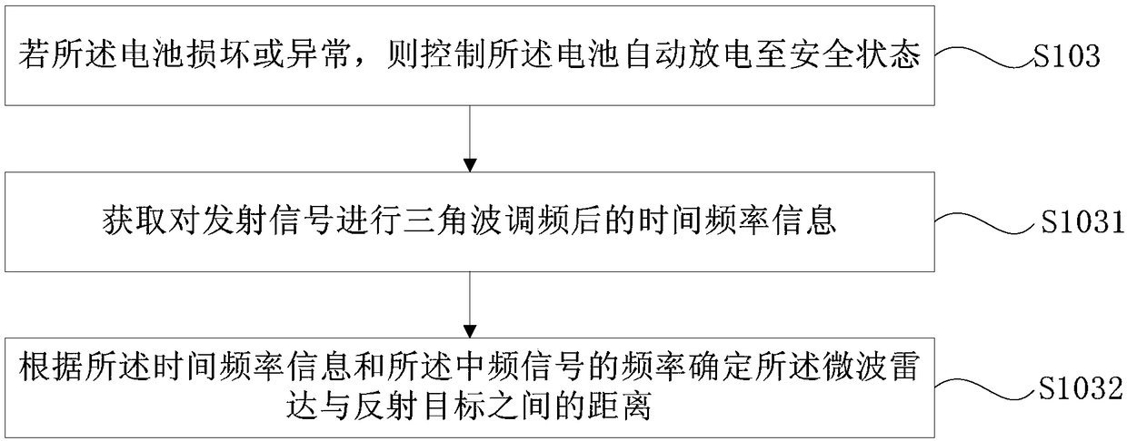
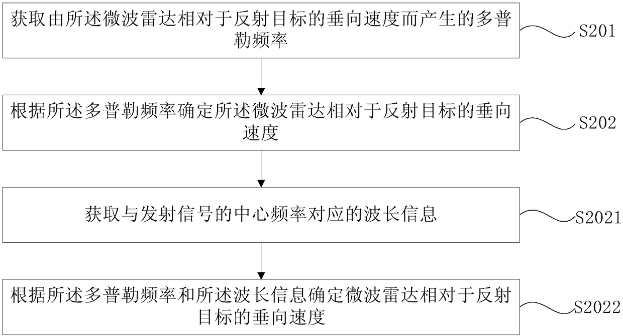
[0041] In order to make the purpose, technical solutions and advantages of the embodiments of the present invention clearer, the technical solutions in the embodiments of the present invention will be clearly and completely described below in conjunction with the drawings in the embodiments of the present invention. Obviously, the described embodiments It is a part of embodiments of the present invention, but not all embodiments. Based on the embodiments of the present invention, all other embodiments obtained by persons of ordinary skill in the art without making creative efforts belong to the protection scope of the present invention.

[0042] Unless otherwise defined, all technical and scientific terms used herein have the same meaning as commonly understood by one of ordinary skill in the technical field of the invention. The terms used herein in the description of the present invention are for the purpose of describing specific embodiments only, and are not intended to li...


PUM


Abstract

The present invention provides a microwave radar (200) ranging method, a microwave radar (200), a computer storage medium, an unmanned aerial vehicle and a control method thereof. The ranging method comprises the steps of: controlling a signal transmitter of the microwave radar (200) to transmit a microwave signal when the signal transmitter rotates around a rotating shaft (S101);acquiring a frequency of the intermediate frequency signal mixed by the frequency of the transmitting signal and the frequency of the echo signal (S102); and determining the distance between the microwave radar (200)and the reflected target according to the frequency of the intermediate frequency signal (S103). The signal transmitter of the microwave radar (200) is controlled to emit the microwave signal when thesignal transmitter rotates around a rotating shaft to obtain the distance between the microwave radar (200) and the reflected target according to the frequency of the intermediate frequency signal soas to determine the height information and the landform information of the microwave radar (200), effectively ensure the safety and the reliability of the flight of the aircraft and further improve the practicability of the distance measurement method.

Description

technical field [0001] The invention relates to the technical field of agricultural drones, in particular to a microwave radar ranging method, a microwave radar, a computer storage medium, an unmanned aerial vehicle and a control method thereof. Background technique [0002] With the rapid development of science and technology, the technology of unmanned aerial vehicles is becoming more and more mature, and there are more and more fields where unmanned aerial vehicles can be applied. For example, unmanned aerial vehicles can serve many fields such as agriculture, forestry, transportation, water conservancy and military. Among them, unmanned aerial vehicles have played an important role in the field of agricultural aviation technology. [0003] During the working process of the agricultural unmanned aerial vehicle, it is necessary to obtain the flight altitude of the agricultural unmanned aerial vehicle. In the prior art, the agricultural unmanned aerial vehicle generally use...

Claims


Application Information

Patent Timeline
Patent Type & Authority Applications(China)
IPC IPC(8): G01S17/93G05D1/10G01S13/933
CPCG05D1/101G01S17/933G01S13/90G01S17/93G01S13/933G01S13/882G01S13/426G01S13/345G01S13/584G01S13/60G05D1/102B64C39/024B64U2201/10G01S13/935B64C39/02H01Q1/28G05D1/106B64U2101/00
Inventor 王俊喜王春明吴旭民
Owner SZ DJI TECH CO LTD
Why Eureka
Try Eureka