
Method for predicting target in unmanned aerial vehicle autonomous recovery based on navigation information

A technology of target prediction and navigation information, which is applied in navigation computing tools and other directions, can solve problems such as poor position and pose estimation effects of position changes, limitations of onboard processing capabilities, and inability to meet real-time requirements, so as to reduce detection time and improve real-time performance and accuracy effects

Active Publication Date: 2018-10-12
NAT UNIV OF DEFENSE TECH
View PDF5 Cites 4 Cited by
  • Summary
  • Abstract
  • Description
  • Claims
  • Application Information

AI Technical Summary

Problems solved by technology

[0003] At present, the commonly used autonomous recovery method is based on the cooperative target method, which estimates the relative pose of the UAV by detecting and tracking the cooperative target on the ground or on the vehicle. However, the load of small UAVs is limited and the onboard processing capacity is limited. , the conventional cooperative target-based method may not meet the real-time requirements, or the position estimation effect of the cooperative target is poor due to the rapid change of the position of the cooperative target in the image.
[0004] Therefore, there is an urgent need to study a method to solve the problem of real-time and accuracy of cooperative target prediction in the autonomous recovery of UAVs to a certain extent.

Method used


Image

  • Method for predicting target in unmanned aerial vehicle autonomous recovery based on navigation information
  • Method for predicting target in unmanned aerial vehicle autonomous recovery based on navigation information
  • Method for predicting target in unmanned aerial vehicle autonomous recovery based on navigation information

Examples


specific Embodiment

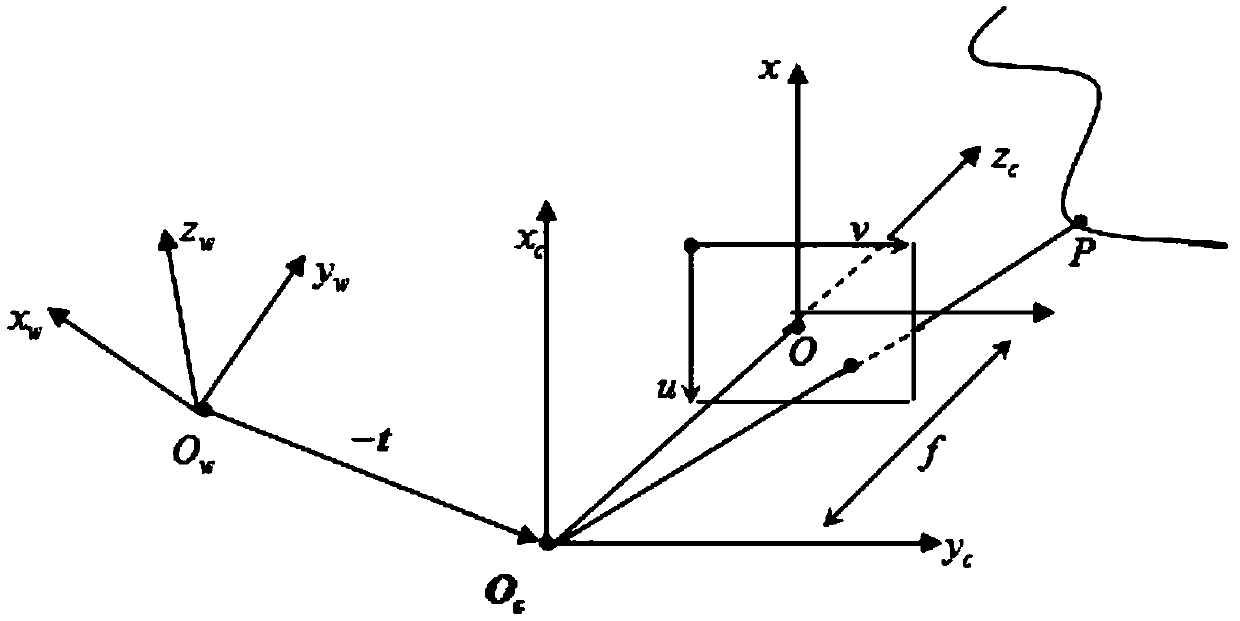
[0031] Case: Suppose the focal length of the camera is f x = f y =1000, the resolution is 1280×720; current t k The projection of the moment drone in the world coordinate system The attitude rotation matrix of the drone is the identity matrix, the rotation matrix of the camera and the UAV body The cooperative target on the ground moves at a constant speed of 2m / s, and the spatial position sequence of the cooperative target estimated earlier Where i=1,...5 (take 5 values ​​here as an example, the interval dt=0.2s), respectively (9.2,8.9,0.1), (9.3,9.3,0.15), (9.15,9.5,0.2), ( 9.25,9.8,0.05), (9.5,10.2,0.12).

[0032] need to predict the current t k Cooperate with the imaging position of the target at all times.

[0033] Adopt the inventive method, step is as follows:

[0034] 1) According to the known spatial position sequence of the cooperative target, due to the movement of the cooperative target, first, according to the formula (3) based on the spatial position s...


PUM


Abstract

The invention provides a method for predicting target in unmanned aerial vehicle autonomous recovery based on navigation information, aiming at a case that a cooperative target moves. That the cooperative target moves means the displacement component of the cooperative target in the world coordinate system changes, that is the value shown in the specification changes. In the process of unmanned aerial vehicle autonomous recovery, the unmanned aerial vehicle can provide navigation information, such as pose in real time. The method is based on the pose information of the unmanned aerial vehicleat a previous time, and relevant numerical methods are used for fitting a movement curve of the cooperative target. According to the curve, the spatial movement position of the cooperative target at the current moment is estimated, and imaging points of the cooperative target is predicted by combining the navigation information. The method can be used for predicting an imaging area of the cooperative target by combining the navigation information, and only target detection tracking and relative pose calculation in the area are carried out, so that real-time performance and accuracy of the cooperative target pose estimation algorithm are improved.

Description

technical field [0001] The invention relates to the technical field of autonomous recovery of unmanned aerial vehicles, in particular to a method for predicting targets of autonomous recovery of unmanned aerial vehicles based on navigation information. Background technique [0002] At present, the autonomous recovery of drones (ground recovery or vehicle recovery, etc.) is a research hotspot and difficulty in the civilian field. To achieve safe autonomous recovery, accurate and real-time relative pose estimation is the basis, especially for small drones. It is even more challenging for man-machines (especially UAVs moving at high speed). [0003] At present, the commonly used autonomous recovery method is based on the cooperative target method, which estimates the relative pose of the UAV by detecting and tracking the cooperative target on the ground or on the vehicle. However, the load of small UAVs is limited and the onboard processing capacity is limited. , the conventio...

Claims


Application Information

Patent Timeline
Patent Type & Authority Applications(China)
IPC IPC(8): G01C21/20
CPCG01C21/20
Inventor 方强唐邓清赵框周正元周晗周勇曹正江王树源高平海胡天江
Owner NAT UNIV OF DEFENSE TECH
Learn More