A Global Grid-based Spatial Information Organization Method for Administrative Divisions

A technology for administrative divisions and spatial information, applied in geographic information databases, structured data retrieval, etc., can solve the problems of unmatched division types, few levels of identification, manual participation, etc., and is conducive to refined sharing and sharing, simple composition structure , to ensure the effect of real-time

Active Publication Date: 2021-12-14
PEKING UNIV
View PDF4 Cites 0 Cited by
  • Summary
  • Abstract
  • Description
  • Claims
  • Application Information

AI Technical Summary

Problems solved by technology

[0008] On the one hand, although the standard coding granularity of various countries is sufficient, its design is closely related to its own characteristics. Structural features such as digital or alphabetic, divided into several layers, and the number of layers in each layer are directly related to factors such as the scope of administrative divisions. It is difficult to directly promote the uniform coding of global administrative divisions
For example: Russia's administrative division code is divided into three layers, and if it is used for my country's six-level division or India's fourth / fifth-level division, there will be fewer identification levels. India's division type does not match
[0009] On the other hand, according to the current coding principle of unified coding of global administrative divisions, when the coding granularity is increased to all levels, there are many administrative division units that need to be coded, and the workload of coding is huge. The coding value of the administrative division unit cannot be determined by its own information. Problems such as duplicate names, different words with the same pronunciation, the same initial letter, new and old divisions and other issues have exacerbated the complexity of coding. The workload limits the encoding granularity
[0010] The existing administrative division coding methods are difficult to balance the coding range and coding granularity, and there are still few coding systems that can support the unified identification of administrative divisions at all levels in the world
[0011] (2) It is difficult to support the description of any location within the administrative division
[0012] The administrative division codes of some countries such as the United Kingdom, the United States, and China can be extended to finer granularity, beyond the scope of administrative divisions. In essence, this is a manifestation of the scalability of administrative division codes, describing the internal location of administrative divisions. There are two problems in the traditional method: first, it only expands downwards from the finest level or a specified level, and does not provide internal location description methods for all levels of administrative divisions; second, the area boundaries represented by codes are artificially defined as It is usually only mastered by individual departments, and the scope and accuracy of the division of urban areas are better than those of rural areas.
However, the traditional method follows the idea of ​​administrative division coding. The coding in sequence or abbreviation contains limited effective information and does not have the ability to split. Therefore, it cannot support the description of any location within the administrative division, which is not conducive to the refined sharing and sharing of spatial data.
[0014] (3) It is not conducive to the associated application of administrative division data
However, the continuity of longitude and latitude leads to the infinity of coordinate points, and there are shortcomings in the identification of regional administrative division units and spatial locations, which is not conducive to the associated application of data

Method used


Image

  • A Global Grid-based Spatial Information Organization Method for Administrative Divisions
  • A Global Grid-based Spatial Information Organization Method for Administrative Divisions
  • A Global Grid-based Spatial Information Organization Method for Administrative Divisions

Examples


Embodiment 1

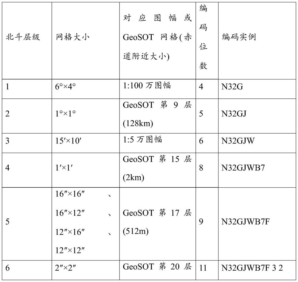
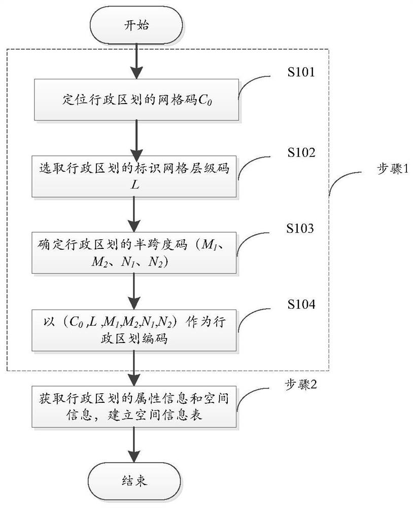
[0047] Embodiment 1. The embodiment of the present invention provides a method for organizing spatial information in an administrative division based on a global grid, and its process is as follows figure 1 As shown, the method includes the following steps:

[0048] Step 1. Determine the administrative division code, which specifically includes the following steps:

[0049] S101. Grid code C for locating administrative divisions 0 .

[0050] In the "GB / T 23705-2009 Digital City Geographic Information Public Platform Place Name / Address Code Rules", the geographical location of the name of the administrative division is represented by the point coordinates of the government office of the administrative division, and the geographical location of the door (building) is represented by the door (building) The point coordinates of the location of the ) sign are indicated. In order to be consistent with the current national standards and make better use of existing data, considering...

Embodiment 2

[0068] Embodiment 2, the embodiment of the present invention On the basis of embodiment 1, after step 1 and before step 2, the following steps are added, specifically as figure 2 Shown:

[0069] Step 11, determining the location short code of any coordinate point p within the administrative division; specifically, the following steps are included:

[0070] S1101. Obtain the boundary of the administrative division, calculate all the L-level GeoSOT grids crossed by the boundary segment by segment, and calculate the internal L-level GeoSOT grids between the boundary grids row by row, to obtain the first layer location grid set. image 3 A gridding example of the administrative division is given, where (a) is a schematic diagram of the boundary of the administrative division, (b) is a schematic diagram of the gridding result of the administrative division boundary, and (c) is a schematic diagram of the gridding inside the administrative division.

[0071] S1102. Perform row numb...


PUM


Abstract

The invention discloses a method for organizing spatial information of administrative divisions based on a global grid. The method includes the following steps: setting the level A of the grid code, and using the point coordinates of the government offices of the administrative divisions to be identified to be located The Beidou navigation grid code of the level A grid is used as the grid code C of the administrative division 0 ; Select the identification grid level code L of the administrative division: determine the half-span code of the administrative division (M 1 , M 2 , N 1 , N 2 ); under the logo grid level code L level of the administrative division, the number of grids on the upper, lower, right and left four boundaries of the smallest outsourcing rectangle of the administrative division is represented by hexadecimal characters 0-F, respectively denoted as M 1 , M 2 , N 1 , N 2 ; with (C 0 , L, M 1 , M 2 , N 1 , N 2 ) as the administrative division code; obtain the attribute information and spatial information of the administrative division, establish a spatial information table, and use the administrative division code as the primary key to record the attribute information and spatial information of the administrative division unit in the spatial information table.

Description

technical field [0001] The invention relates to the technical field of subdivision and organization of geospatial information, in particular to a method for organizing spatial information of administrative divisions based on a global grid. Background technique [0002] Administrative division codes can be divided into numeric codes, letter codes and mixed codes according to different forms of expression, hierarchical codes and non-hierarchical codes according to whether they reflect the structural characteristics of administrative divisions, and can be divided into sequential codes, Abbreviation codes, combined codes, etc., are rare random meaningless unique codes. [0003] When international organizations or research institutions involve transnational data processing and information exchange, they usually use UN M49, ISO3166, FIPS 10-4 / GENC, HASC, SALB, NUTS and other global or regional administrative division uniform codes. According to the compilation method, the above c...

Claims


Application Information

Patent Timeline
Patent Type & Authority Patents(China)
IPC IPC(8): G06F16/29
Inventor 程承旗童晓冲杨肖宁陈波濮国梁
Owner PEKING UNIV
Why Eureka
Try Eureka