An Indoor Positioning and Path Planning Method for Fire Fighting and Rescue Situations

An indoor positioning and path planning technology, applied in satellite radio beacon positioning systems, surveying and navigation, instruments, etc., can solve the problems of low positioning accuracy, wide deployment range, and unusability, so as to reduce risks and increase action speed , Improving the effect of fire fighting and rescue capabilities

Active Publication Date: 2021-10-08
THE 28TH RES INST OF CHINA ELECTRONICS TECH GROUP CORP
View PDF3 Cites 0 Cited by
  • Summary
  • Abstract
  • Description
  • Claims
  • Application Information

AI Technical Summary

Problems solved by technology

For indoor situations, outdoor positioning and path planning systems often rely on a good outdoor network and data foundation, but Beidou / GPS and cellular signals will be seriously attenuated after entering the room, and there will be serious multipath effects at the same time, and the positioning accuracy is very low
The UWB (UltraWideband) system can achieve high-precision indoor positioning, but it needs to be deployed in the building in advance. The deployment range is wide and difficult, and it cannot be used in the event of a fire and power failure.

Method used


Image

  • An Indoor Positioning and Path Planning Method for Fire Fighting and Rescue Situations
  • An Indoor Positioning and Path Planning Method for Fire Fighting and Rescue Situations
  • An Indoor Positioning and Path Planning Method for Fire Fighting and Rescue Situations

Examples


Embodiment Construction

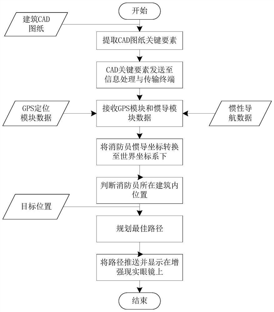
[0029] The present invention will be further described below in conjunction with the accompanying drawings and embodiments.

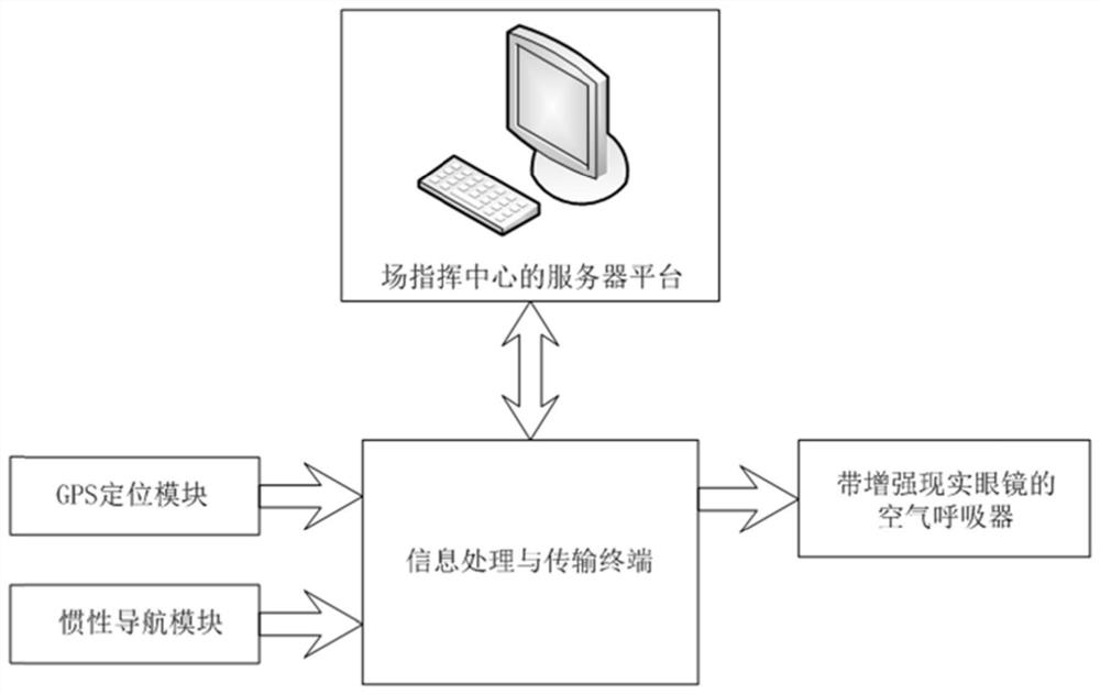
[0030] see figure 1 . An indoor positioning and path planning method for fire fighting and rescue situations includes an on-site command center server platform, a GPS positioning module, an inertial navigation module, an air respirator with augmented reality glasses, an information processing and transmission terminal and other equipment carried by firefighters.

[0031] The on-site command center server platform refers to the computer software and hardware platform in the command vehicle at the fire fighting and rescue site, which communicates with firefighters inside the fire site through wireless transmission technology, transmits command orders and auxiliary information to firefighters, and Receive on-scene information transmitted by firefighters from inside a burning building.

[0032] The GPS positioning module is used to record in real time the...


PUM


Abstract

The invention discloses an indoor positioning and path planning method in the case of fire fighting and rescue. The method comprises a server platform of an emergency field command center, a GPS positioning module, an inertial navigation module, and an air respirator equipped with augmented reality glasses for firefighters. , and the terminal equipment for information processing and transmission, through GPS positioning and inertial navigation positioning, obtain the conversion relationship between the inertial navigation coordinate system and the world coordinate system, and obtain the specific position of the firefighters inside the building. Then, according to the target location specified by the command center, plan the best indoor path for firefighters to the target location. Through the method of the invention, the fire fighting and rescue action speed of the firefighters can be effectively improved, and the action safety of the firefighters can be guaranteed.

Description

technical field [0001] The invention relates to an indoor positioning and optimal path planning method, in particular to an indoor positioning and path planning method in the case of fire fighting and rescue. Background technique [0002] With the rapid development of cities, large building fires occur from time to time. When carrying out fire fighting and rescue inside a large building, due to the extremely high smoke concentration at the fire scene and the complex internal structure of the building, firefighters are prone to lose their way, slow down their action speed, miss the best time for fire fighting and rescue, and increase the risk of firefighters' own safety . [0003] The relatively mature positioning and path planning systems are mainly outdoor positioning and path planning systems, such as the outdoor vehicle-mounted positioning and path planning systems of AutoNavi and Google. The above positioning methods are widely based on the global positioning system, a...

Claims


Application Information

Patent Timeline
Patent Type & Authority Patents(China)
IPC IPC(8): G06Q10/04G06F16/29G01S19/49G01C21/20
CPCG01C21/343G01S19/49G06Q10/047
Inventor 王方顺周详欧乐庆江春杨波俞振东张崟刘超李翠侠周展
Owner THE 28TH RES INST OF CHINA ELECTRONICS TECH GROUP CORP
Why Eureka
Try Eureka