Multi-source satellite soil humidity inversion method

A soil moisture and satellite technology, which is applied in the field of multi-source satellite soil moisture inversion, can solve the problems of soil moisture characteristic analysis, difficulty in showing the spatial distribution of soil moisture, and low spatial resolution of soil moisture, so as to ensure objective rationality, The effect of stable and reliable data sources and high spatio-temporal resolution

Active Publication Date: 2018-11-06
HOHAI UNIV
View PDF7 Cites 16 Cited by
  • Summary
  • Abstract
  • Description
  • Claims
  • Application Information

AI Technical Summary

Problems solved by technology

At present, the classic measurement methods for obtaining soil moisture mainly include: weighing method, tensiometer method, neutron method, resistance method, etc. Although the soil moisture obtained by manual observation at the station has high accuracy, it is impossible to deploy stations in areas with sparse stations or complex terrain. The measurement method has shortcomings such as block lack of measurement and discontinuous data, and it is difficult to show the spatial distribution of soil moisture.
[0003] The development of satellite remote sensing technology provides an effective means for obtaining regional-scale soil moisture information. However, the spatial resolution of surface soil moisture retrieved by satellite remote sensing is low, and th

Method used


Image

  • Multi-source satellite soil humidity inversion method
  • Multi-source satellite soil humidity inversion method
  • Multi-source satellite soil humidity inversion method

Examples


Embodiment Construction

[0053] The present invention will be further described below in conjunction with the accompanying drawings and specific embodiments.

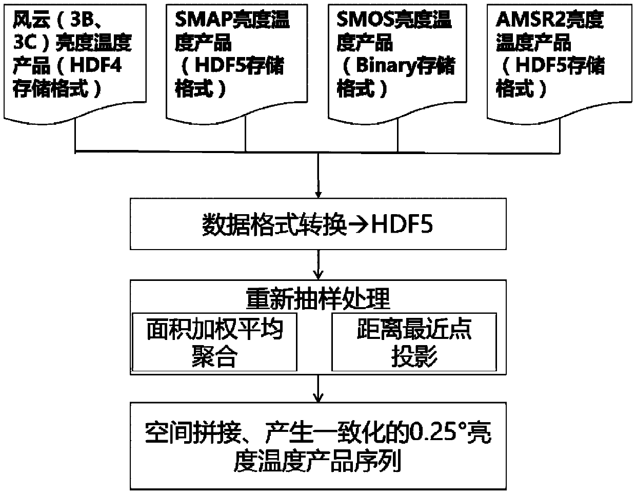
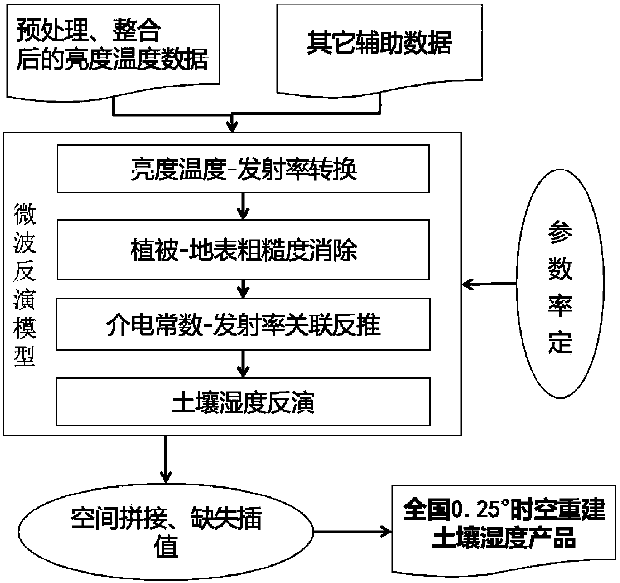
[0054] Such as figure 1 and 2 As shown, a method for multi-source satellite soil moisture inversion and spatial-temporal reconstruction provided by the present invention includes the following steps: Step 1, collecting brightness temperature data with high temporal and spatial resolution at home and abroad, and according to the characteristics of different satellite brightness temperatures, Carry out data format conversion, resampling, spatial splicing, and generate a consistent sequence of brightness and temperature products with the same spatial resolution (0.25°), specifically:

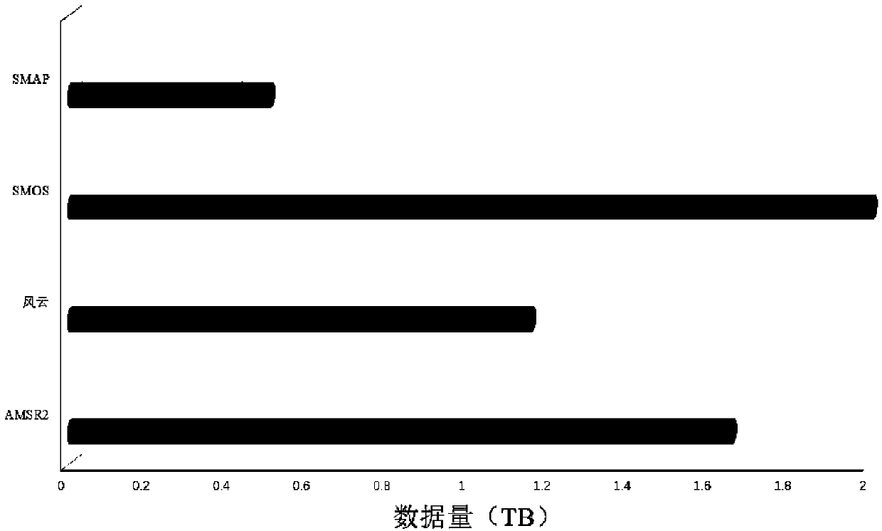
[0055] Step 11, collect domestic and foreign brightness temperature data;

[0056] Step 12, the format of the brightness temperature data of different satellites is different, and the data format is converted, and it is uniformly converted to HDF5;

[0057] Step ...


PUM


Abstract

The invention discloses a multi-source satellite soil humidity inversion method which is characterized by comprising the following steps: collecting brightness temperature data of a multi-source satellite, and obtaining a uniformed brightness temperature product sequence of an identical spatial resolution; establishing a soil humidity microwave sensing inversion model, carrying out brightness temperature to emissivity conversion, and extracting grid emissivity of a microwave radiation meter scanning track one by one; ejecting and correcting influence of vegetation and ground surface roughness;converting soil dielectric constants into the emissivity, carrying out correlated thrust reversion on the converted dielectric constants and soil humidity, thereby obtaining remote sensing inversionon the soil humidity. Quasi real-time brightness temperature data observed by multiple satellite platforms are adopted as main input data, brightness temperature data of different satellite sources are cut and spliced, inversion and space-time reconstruction on moisture of soil on a surface layer are achieved, and continuous soil humidity products of high space-time resolutions can be acquired.

Description

technical field [0001] The invention belongs to the technical field of hydrological remote sensing, and in particular relates to a multi-source satellite soil moisture inversion method. Background technique [0002] Soil moisture is an important surface parameter in research fields such as climate, numerical weather prediction, hydrological prediction, agricultural drought monitoring and forecasting, and land surface data assimilation. At present, the classic measurement methods for obtaining soil moisture mainly include: weighing method, tensiometer method, neutron method, resistance method, etc. Although the soil moisture obtained by manual observation at the station has high accuracy, it is impossible to deploy stations in areas with sparse stations or complex terrain. The measurement method has shortcomings such as lack of block measurement and discontinuous data, and it is difficult to show the spatial distribution of soil moisture. [0003] The development of satellit...

Claims


Application Information

Patent Timeline
IPC IPC(8): G01N33/24
CPCG01N33/246
Inventor 张珂晁丽君
Owner HOHAI UNIV
Why Eureka
Try Eureka