A shadow-based method for building height estimation from high-resolution remote sensing images

A technology of building height and remote sensing images, applied in photogrammetry/video metrology, image analysis, image enhancement, etc., can solve the problems of insufficient historical data, troublesome data acquisition, and difficulty in estimating the length of building shadows, etc., to achieve Strong operability and clear processing methods

Active Publication Date: 2022-03-04
WUHAN UNIV
View PDF4 Cites 0 Cited by
  • Summary
  • Abstract
  • Description
  • Claims
  • Application Information

AI Technical Summary

Problems solved by technology

The existing high-resolution image 2D building height estimation mainly has the following problems: (1) Data acquisition is more troublesome, and historical data is insufficient
(2) The original parameters such as the imaging time of the image are required to calculate the sun elevation angle, but a considerable part of the imaging-related parameters of the orthophoto image is missing; (3) It is difficult to estimate the height of the building when there is a certain shadow in the shadow of a tall building shadow length

Method used


Image

  • A shadow-based method for building height estimation from high-resolution remote sensing images
  • A shadow-based method for building height estimation from high-resolution remote sensing images
  • A shadow-based method for building height estimation from high-resolution remote sensing images

Examples


Embodiment Construction

[0032] The technical solution of the present invention will be described in detail below in conjunction with the drawings and embodiments.

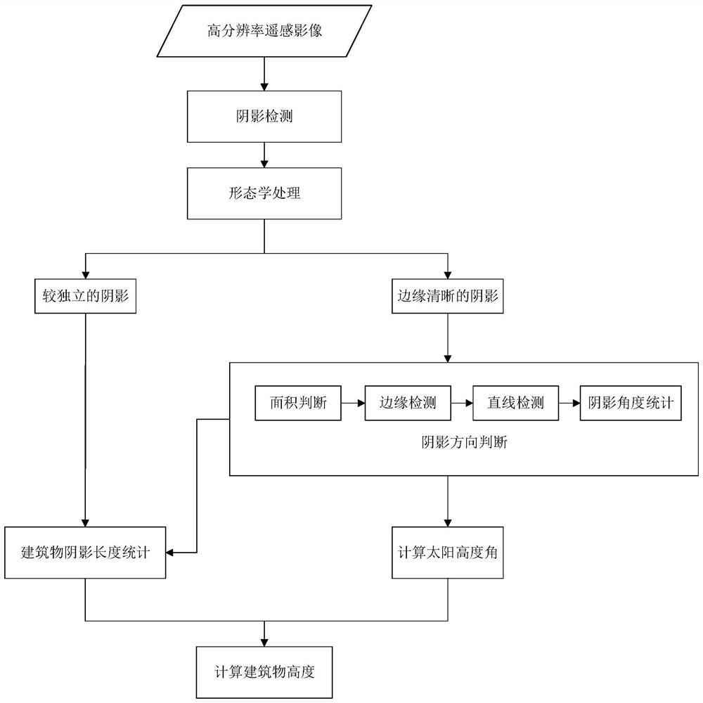
[0033] The present invention is a method for estimating the building height of high-resolution remote sensing images based on shadows, including using spectral characteristics to detect shadows, and performing morphological processing on shadows; using the area and length of shadows, and the imaging characteristics of satellite images to determine shadows Then determine the shadow length corresponding to the building through the shadow direction and the statistical characteristics of the corresponding shadow length of the building; then calculate the sun azimuth angle through the shadow direction, and calculate the sun altitude angle through the sun azimuth angle; finally use the calculated shadow length and solar elevation angle to estimate the height of the building.

[0034] Such as figure 1 , the flow process of the technical solutio...


PUM


Abstract

The present invention provides a method for estimating the building height of a high-resolution remote sensing image based on shadow information, which includes performing shadow detection on the original image to be detected, obtaining a shadow detection result map, and using morphological processing to obtain more independent shadows and edge details. Smooth shadow; determine the shadow direction by using the shadow area, length, and imaging characteristics of satellite images; determine the corresponding shadow length of the building through the statistical characteristics of the shadow direction and the corresponding shadow length of the building; calculate the sun azimuth through the shadow direction, And calculate the sun altitude angle through the sun azimuth; use the obtained shadow length and sun altitude angle to estimate the height of the building. The invention realizes building height estimation by making full use of the characteristics of building shadows, effectively detects building heights in remote sensing images with shadows, and provides remote sensing-related applications such as building three-dimensional reconstruction, urban building historical information acquisition, and urban change detection. Provide valid information.

Description

technical field [0001] The invention relates to the technical field of remote sensing image processing, in particular to a shadow-based method for estimating building heights of high-resolution remote sensing images. Background technique [0002] Buildings are one of the main features of a city and are closely related to human habitation and life. In the past ten years, the ability to obtain remote sensing data has been greatly improved in terms of spatial and temporal resolution. High-resolution imagery provides the basis for us to study the details of urban areas, especially buildings. The height of a building is one of the most distinctive features that distinguish a building from other urban features. Moreover, building height information is increasingly important in urban 3D modeling, urban monitoring, urban planning, map updating, and population estimation. Therefore, it is necessary to study a practical method for building height estimation. [0003] The existing ...

Claims


Application Information

Patent Timeline
Patent Type & Authority Patents(China)
IPC IPC(8): G06T7/62G06T7/60G06T7/13G06T7/155G06T7/00G01C11/00
CPCG06T7/0002G06T7/13G06T7/155G06T7/60G06T7/62G01C11/00G06T2207/30181G06T2207/10032G06T2207/20036
Inventor 孙开敏张宏雅李文卓眭海刚马国锐刘俊怡
Owner WUHAN UNIV
Why Eureka
Try Eureka