Robot path planning and environment rebuilding method and system based on virtual reality

A path planning and virtual reality technology, applied in the direction of instruments, image data processing, data processing applications, etc., can solve the problems of large resource occupation, slow calculation speed, long time period, etc., achieve less resource occupation, reduce data volume, and improve efficiency effect

Active Publication Date: 2018-11-13
XIAN UNIV OF SCI & TECH
View PDF6 Cites 16 Cited by
  • Summary
  • Abstract
  • Description
  • Claims
  • Application Information

AI Technical Summary

Problems solved by technology

[0004] Aiming at the shortcomings of the existing technology, the purpose of the present invention is to provide a method and system for robot path planning and environment reconstruction based on virtual reality, which solves the problem of using a large number of co

Method used


Image

  • Robot path planning and environment rebuilding method and system based on virtual reality
  • Robot path planning and environment rebuilding method and system based on virtual reality
  • Robot path planning and environment rebuilding method and system based on virtual reality

Examples


Embodiment Construction

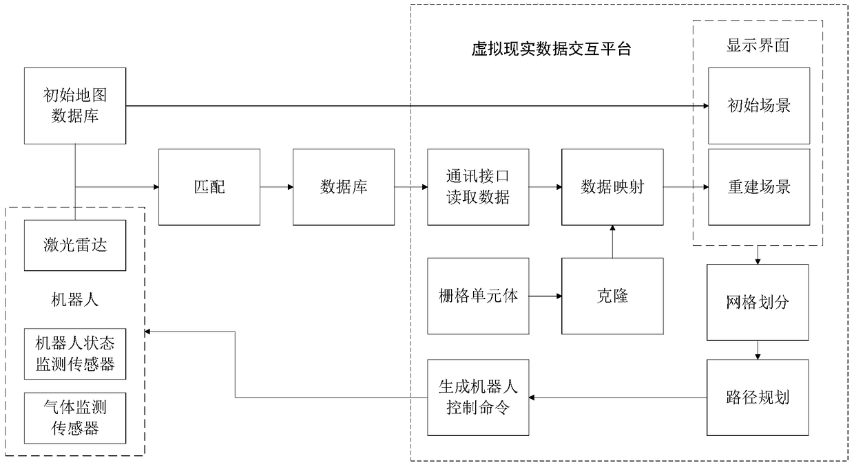
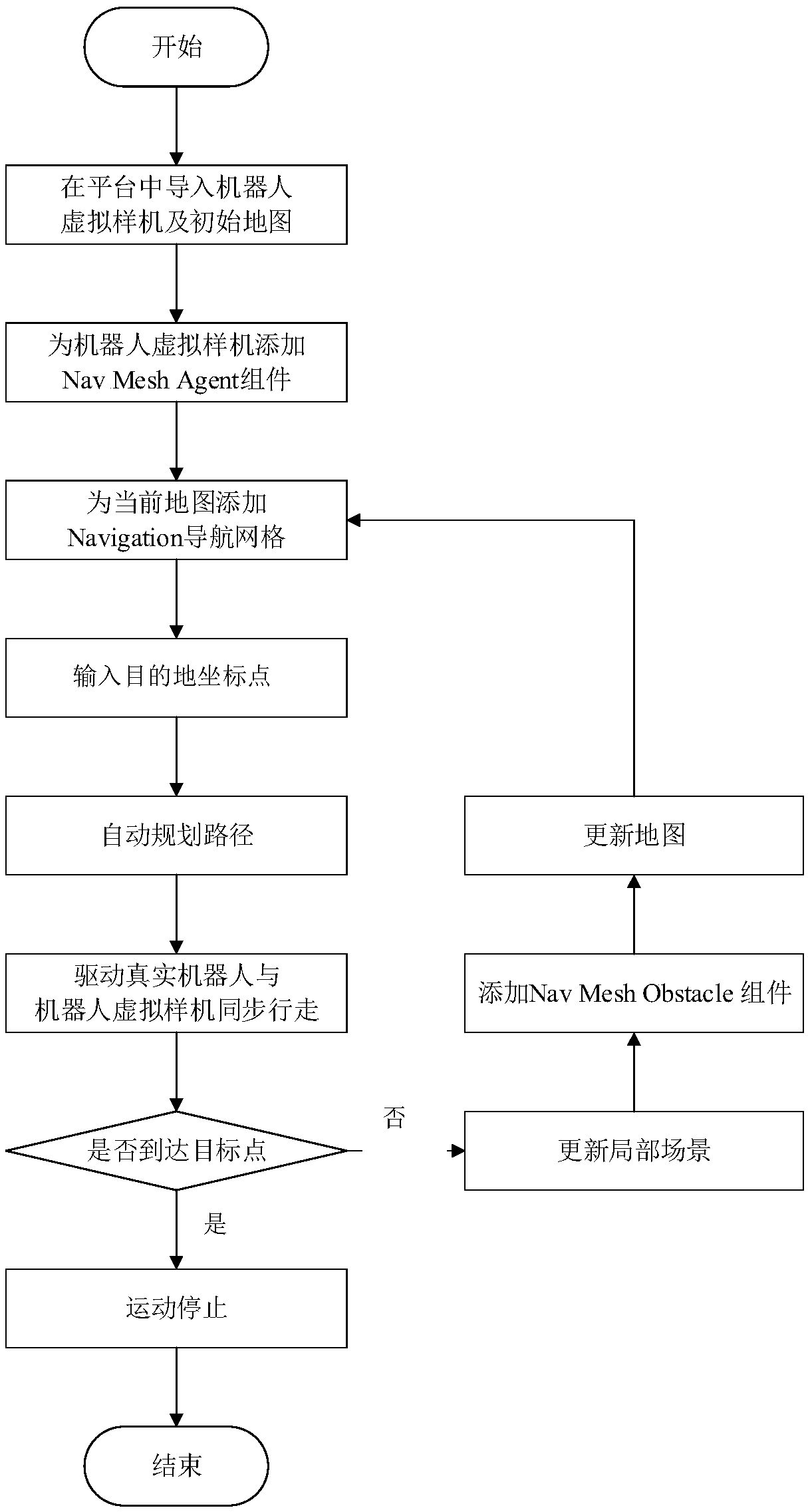
[0034] The present invention uses virtual reality technology to realize the virtual prototype of the detection robot and the initial virtual scene on the virtual simulation interactive platform, and realize the path planning in the virtual scene by processing the scene in the virtual simulation interactive platform, and generate control commands to drive the real The detection robot moves synchronously with the virtual prototype; during the movement, the laser radar is used to collect real-time scene data to realize the reconstruction of the scene, and a new path is planned based on the reconstructed scene. The "environment" reconstruction in the name of the invention refers to the scene in the technical content.

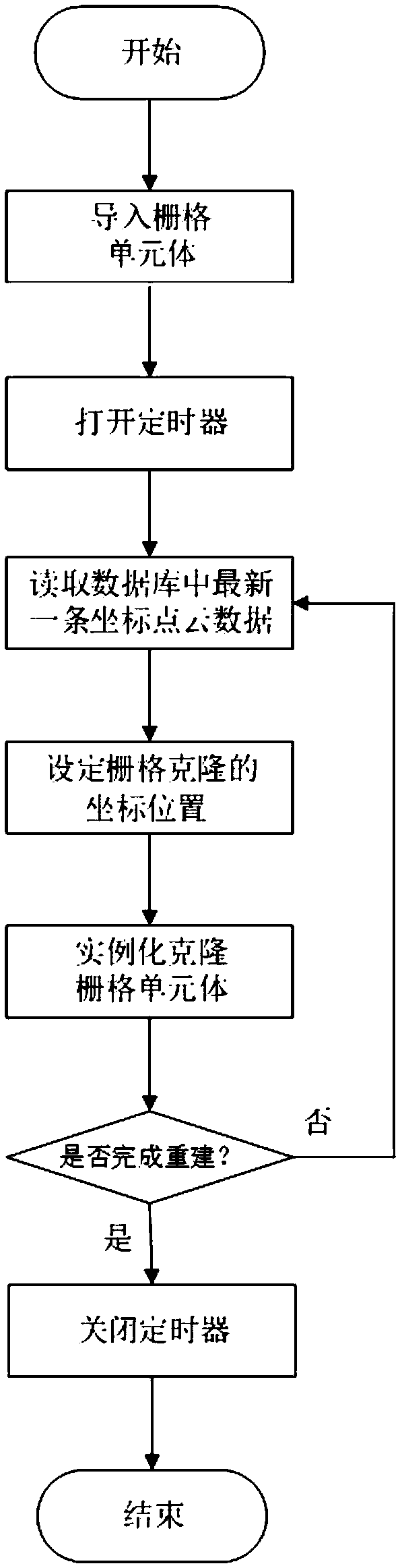
[0035] The 3D grid map is to divide the space into 3D grids of equal size, use the state of each grid to describe the actual space state, and update the 3D grid in real time through the acquired sensor data, so as to realize the creation of the 3D grid map However, ...


PUM


Abstract

The invention discloses a robot path planning and environment rebuilding method and system based on virtual reality. The method comprises the steps of firstly, importing a robot virtual prototype andan initial scene into a virtual simulation interaction platform; generating a navigation grid for the current scene in the platform; according to three-dimensional coordinates of the detection robot virtual prototype and three-dimensional coordinates of a destination, obtaining a walking path of the detection robot virtual prototype in the initial virtual scene; generating a control command for simultaneously driving the robot virtual prototype and a real robot to synchronously move; continuously collecting environment information by the robot; performing local updating and rebuilding on the changed scenes to generate new scenes; and repeating the previous steps in the new scenes. The method has good interactivity, is reasonable in design, high in practicability and high in popularizationvalue, and makes up for the deficiencies of a current coal mine rescue robot control technology.

Description

technical field [0001] The invention belongs to the technical field of robot path planning, and in particular relates to the path planning and scene reconstruction technology of a coal mine post-disaster detection robot, in particular to a method and system for robot path planning and environment reconstruction based on virtual reality. Background technique [0002] Robot path planning technology has always been an important issue in the field of robot research. The so-called path planning problem is to find a suitable movement path for the robot from the starting point to the end point in an environment with obstacles, so that the robot can safely and without collision. through obstacles. At present, traditional path planning methods are based on some specific algorithms, including genetic algorithms, fuzzy logic algorithms, etc., but the main technical problem of path planning methods based on traditional algorithms is that the calculation time period is long in a dynamic ...

Claims


Application Information

Patent Timeline
IPC IPC(8): G06Q10/04G06Q50/02G06T19/00
CPCG06Q10/047G06Q50/02G06T19/006
Inventor 张旭辉董润霖杜昱阳王妙云张雨萌
Owner XIAN UNIV OF SCI & TECH
Why Eureka
Try Eureka