Multi-spectral remote sensing image terrain classification method

A technology for classification of remote sensing images and features, which is applied in the field of classification of multispectral remote sensing images and features, which can solve the problems of different gray values, easy aliasing of spectral integration bands, and high redundancy

Active Publication Date: 2018-11-16
YANTAI UNIV
View PDF3 Cites 3 Cited by
  • Summary
  • Abstract
  • Description
  • Claims
  • Application Information

AI Technical Summary

Problems solved by technology

At present, the problems of remote sensing image classification are: ① remote sensing image data has a large amount of information, high redundancy, strong ambiguity, and it is easily affected by "noise" in the acquisition process; ② in remote sensing image data, different types of ground objects The aliasing phenomenon is easy to appear between the spectr...

Method used


Image

  • Multi-spectral remote sensing image terrain classification method
  • Multi-spectral remote sensing image terrain classification method
  • Multi-spectral remote sensing image terrain classification method

Examples


Embodiment

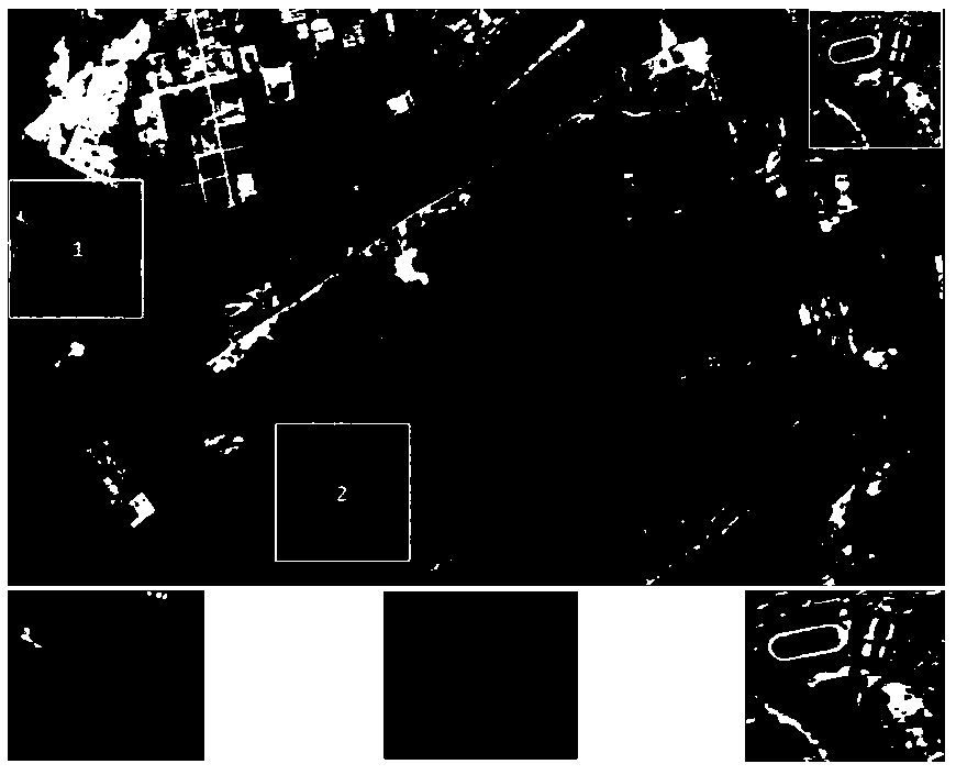
[0058] For those selected from Guangdong Dahengqin Island (to the east of Macao Island, west to Modaomen, south to Sandiequan Scenic Area, north to Baosheng Road) and Beijing Summer Palace (east to Century City, west to Beijing Botanical Garden, south to Xingshikou Road, north to the Summer Palace) image data, to classify large-scale multi-spectral remote sensing images with high-order uncertainties, the specific implementation methods are as follows:

[0059] 1) Determine the number of categories c, the fuzzy index m, the maximum number of iterations T, the threshold ε according to the requirements, initialize the number of iterations t=1, and initialize the objective function J 0 =0; set the multispectral remote sensing image data to be tested as a data set to be tested with n sample points and p features X={x 1 ,x 2 ,...,x n}(x i ={x i1 ,x i2 ,...,x ip}, i=1,2,...,n); U={u 1 , u 2 ,...,u c}(u i ={u i1 , u i2 ,...,u in}, i=1,2,...,c) defines the test data set X ...


PUM


Abstract

The invention, which belongs to the crossing field of data mining and remote sensing image processing, discloses a multi-spectral remote sensing image terrain classification method. A new membership degree calculation formula is designed and a weighted index is reduced appropriately; a marked sample set for some data is obtained based on the expert knowledge and the centroid is initialized by using the marked sample set; restraining is carried out by using marked samples during the iterative calculation of the centroid and the effect of the marked samples is maximized by using a marker trust factor; and a membership interval is constructed by a fuzzy distance measure, an adaptive factor is constructed by using an intra-class mean square error, and the interval length of the membership function is dynamically adjusted to explore an equivalent I-class membership, and the membership is normalized. With the method provided by the invention, a good classification result is obtained; the robustness and well-posedness to large-scale remote sensing image data are high; and compared with the existing fuzzy C-means method, the provided method has the improved precision.

Description

technical field [0001] The invention belongs to the cross field of data mining and remote sensing image processing, and is a multi-spectral remote sensing image ground object classification method. Background technique [0002] Remote sensing technology is the main component of earth observation since the 1980s, and it is widely used in various fields such as national defense security, people's livelihood and economy. With the development and mutual penetration of aerospace technology, pattern recognition, and remote sensing technology, remote sensing images also present the characteristics of multi-spatial resolution, multi-spectrum, and multi-sensor. At present, the problems of remote sensing image classification are: ① remote sensing image data has a large amount of information, high redundancy, strong ambiguity, and it is easily affected by "noise" in the acquisition process; ② in remote sensing image data, different types of ground objects The aliasing phenomenon is ea...

Claims


Application Information

Patent Timeline
IPC IPC(8): G06K9/62G06K9/00
CPCG06V20/10G06F18/23213G06F18/214G06F18/241
Inventor 徐金东冯国政欧世峰阎维青郑强
Owner YANTAI UNIV
Why Eureka
Try Eureka