Road network reconstruction method and system based on mobile phone positioning data

A technology of positioning data and road network, applied in the direction of location information-based services, data processing applications, electronic digital data processing, etc., can solve problems such as missing, insufficient road fineness, etc., and achieve the effect of shortening the extraction time

Inactive Publication Date: 2018-11-30
CHINA UNIV OF GEOSCIENCES (WUHAN)
View PDF4 Cites 25 Cited by
  • Summary
  • Abstract
  • Description
  • Claims
  • Application Information

AI Technical Summary

Problems solved by technology

[0004] The technical problem to be solved by the invention is to provide a refined road network extraction method for the problem of insufficient road finene...

Method used


Image

  • Road network reconstruction method and system based on mobile phone positioning data
  • Road network reconstruction method and system based on mobile phone positioning data
  • Road network reconstruction method and system based on mobile phone positioning data

Examples


Embodiment Construction

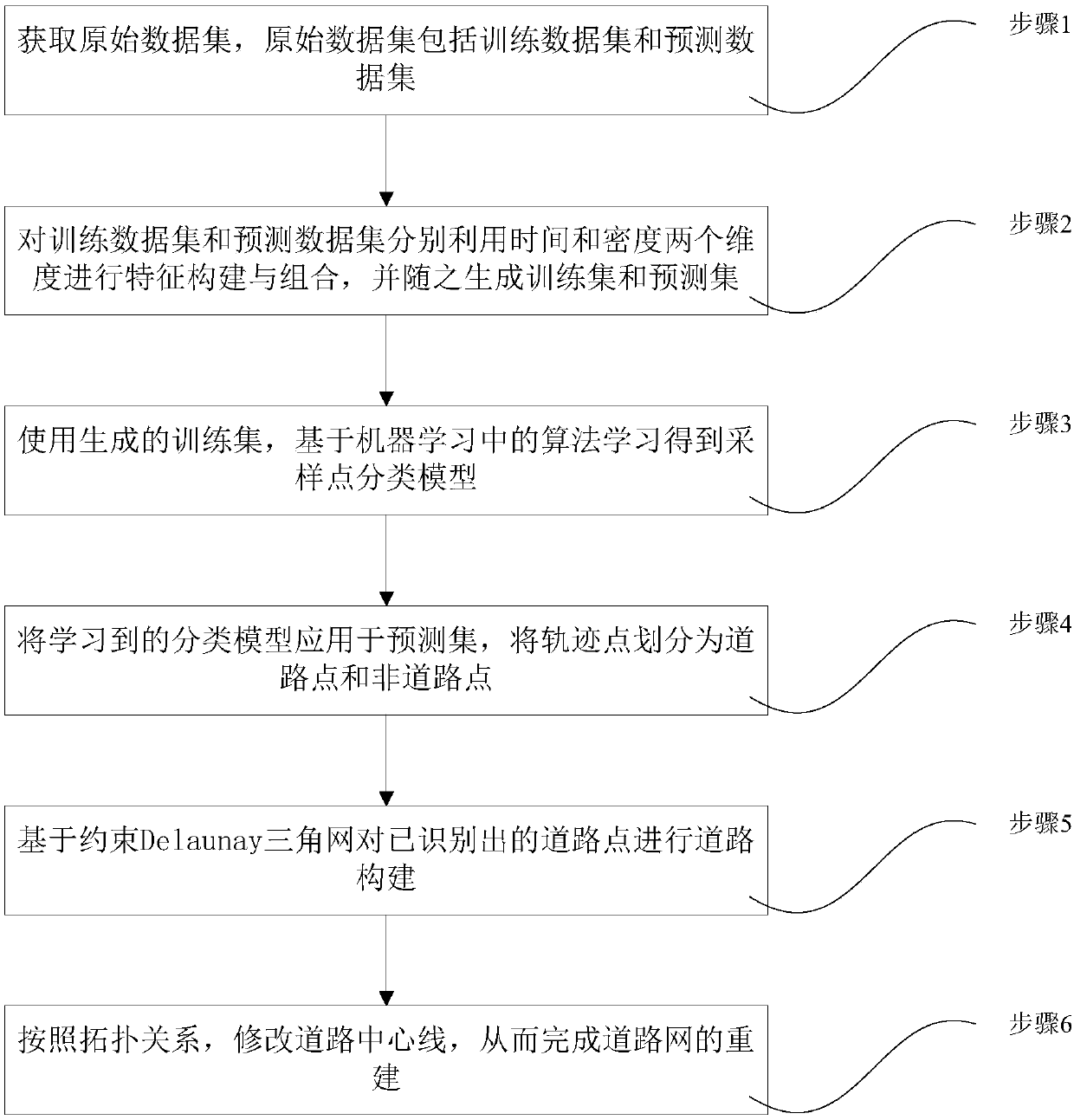
[0030] In order to have a clearer understanding of the technical features, purposes and effects of the present invention, the specific implementation manners of the present invention will now be described in detail with reference to the accompanying drawings.

[0031] The invention relates to a road network reconstruction method based on mobile phone positioning data, which refines the road network. The present invention firstly analyzes the distribution pattern of trajectory points inside a plurality of closed communities, and then selects a plurality of small-scale areas with representative distribution patterns in different communities to construct a training data set, and the remaining part is assigned to a prediction data set, and At the same time, for the track point data in the training data set, manually classify them into road points and non-road points as the label value of the training data; use the two dimensions of time and density to construct and combine features...


PUM


Abstract

The invention discloses a road network reconstruction method and system based on mobile phone positioning data. The method includes: acquiring an original dataset which includes a training dataset anda prediction data set, wherein the original dataset is formed by track points acquired according to mobile phone positioning data; respectively utilizing two dimensionalities like time and density toperform feature construction and combination on the training dataset and the prediction dataset, and generating a training set and a prediction set accordingly; using the generated training set, andacquiring a sampling point classifying model on the basis of an algorithm in machine learning; applying the learned classifying model to the prediction set to divide the track points into road pointsand non-road points; performing road reconstruction on the recognized road points on the basis of a constraint Delaunay triangulation network; according to a topological relation, modifying a road central line to complete reconstruction of a road network. A new mode for high-quality refined road network production and updating is put forward, so that technical support can be provided for seamlessnavigation technology, refined road networks especially, and coverage of path navigation service is expanded.

Description

technical field [0001] The invention relates to spatio-temporal trajectory data mining technology, in particular to a road network reconstruction method and system based on mobile phone positioning data, which belongs to the field of geographic information system and intelligent transportation research. Background technique [0002] Road is an important infrastructure of the city. In the process of rapid urban development, how to supplement and update urban road data in time to maintain its accuracy, timeliness and perfection is an urgent problem to be solved. The scale of residential communities in cities continues to expand, and their internal road networks are becoming more and more sophisticated and complex. However, the existing community-level road information is not fine enough or even missing, resulting in "blind spots" in outdoor detailed navigation in residential areas. Development is a big obstacle. At the same time, the road network structure information is the ...

Claims


Application Information

Patent Timeline
IPC IPC(8): G06F17/30G06Q50/26H04W4/029
CPCG06Q50/26H04W4/029
Inventor 杨林王帅鑫张志勇左泽均李圣文叶亚琴
Owner CHINA UNIV OF GEOSCIENCES (WUHAN)
Why Eureka
Try Eureka