Positioning equipment track optimizing and boundary extracting method and device thereof

A technology for positioning equipment and trajectory optimization, applied in the direction of measuring devices, satellite radio beacon positioning systems, instruments, etc., can solve problems such as low timeliness, high economic costs, abnormal data protrusions, etc., and achieve accurate ground object boundaries, The effect of solving a locally dense, efficient solution

Active Publication Date: 2018-12-04
QIANXUN SPATIAL INTELLIGENCE INC
View PDF6 Cites 15 Cited by
  • Summary
  • Abstract
  • Description
  • Claims
  • Application Information

AI Technical Summary

Problems solved by technology

[0006] The manual interaction post-processing solution requires a large amount of high-resolution image support, and obtaining these high-resolution images requires a high economic cost. Due to the need to involve a large amount of human labor, the human cost expenditure also requires a large amount of money; manual interaction Need to invest a lot of time, resulting in low timeliness
Therefore, the manual interaction processing scheme cannot meet the actual needs
[0007] The existing automatic processing scheme is mainly derived from the navigation and positioning algorithm, which can only optimize a small number of abnormal points, resulting in local abnormal protrusions in the processed data. In addition, it does not solve the problem of trajectory tails and dense areas in the trajectory sequence (area Dense means that there are many irregular track points, and the distance between these track points is smaller than the average distance between track points), resulting in a large error between the boundary of the ground object generated from the track sequence and the actual boundary, which cannot meet the application requirements

Method used


Image

  • Positioning equipment track optimizing and boundary extracting method and device thereof
  • Positioning equipment track optimizing and boundary extracting method and device thereof

Examples


Embodiment 1

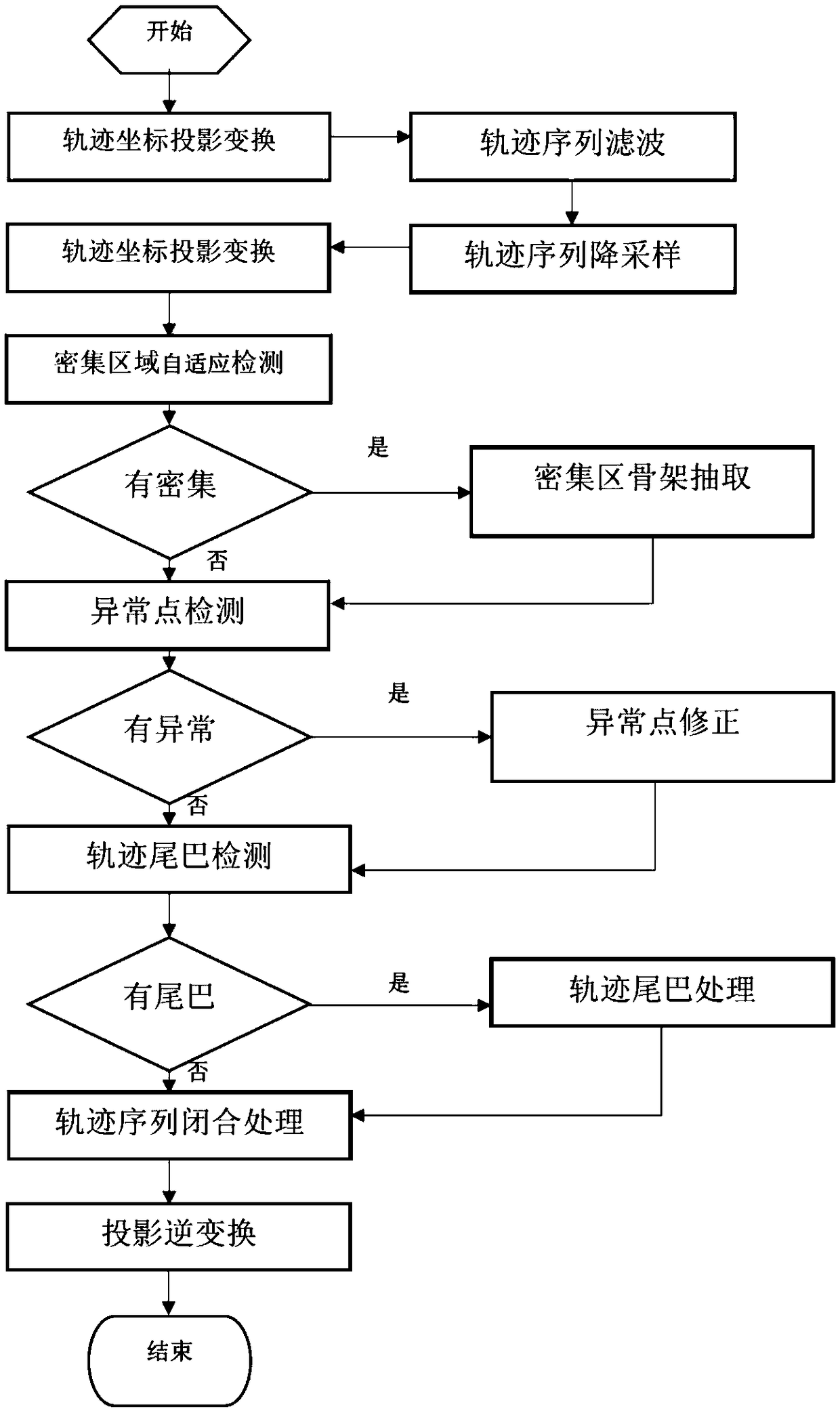
[0066] figure 1 It is a flow chart of the positioning device trajectory optimization and boundary extraction method of the present invention, including the following steps:

[0067] Step 1: Perform "trajectory coordinate projection transformation" processing on the original trajectory sequence output by the positioning device to obtain the coordinates in the plane coordinate system.

[0068] Since the original trajectory uses geographic coordinates to record the position (latitude and longitude), it is not conducive to geometric calculation and analysis. It is necessary to convert the geographic coordinates into plane coordinates. In order to ensure accuracy, the transverse Mercator projection method is usually used for coordinate transformation.

[0069] Step 2: Perform "trajectory sequence filtering" processing on the trajectory sequence after coordinate transformation to reduce accidental positioning errors and improve positioning accuracy.

[0070] In order to reduce the ...

Embodiment 2

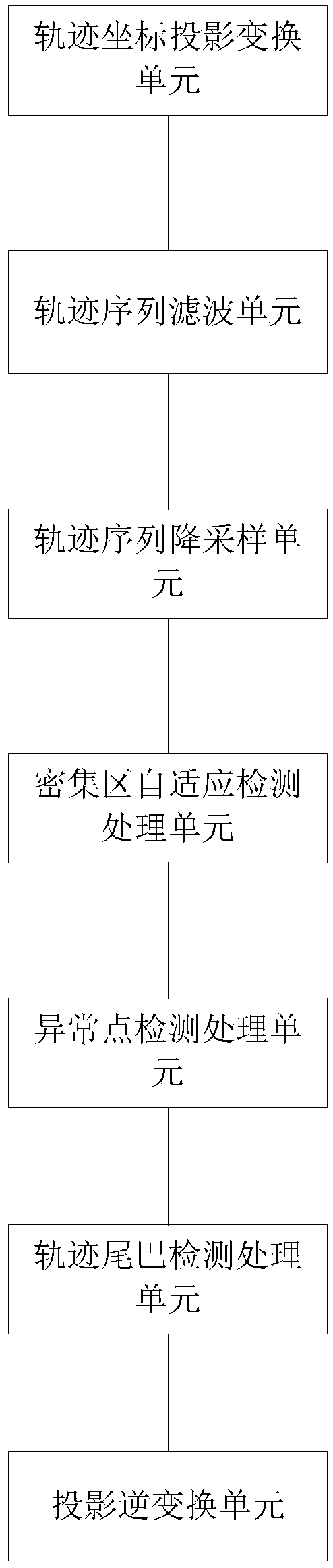
[0094] figure 2 It is a structural diagram of the positioning device trajectory optimization and boundary extraction device of the present invention, the device includes:

[0095] The trajectory coordinate projection transformation unit performs trajectory coordinate projection transformation processing on the original trajectory sequence output by the positioning device to obtain the coordinates in the plane coordinate system;

[0096] The trajectory sequence filtering unit performs trajectory sequence filtering processing on the trajectory sequence after the trajectory coordinate projection transformation;

[0097] The trajectory sequence downsampling unit performs trajectory sequence downsampling processing to remove some redundant trajectory points;

[0098]The dense area adaptive detection processing unit performs dense area adaptive detection processing on the track points after the down-sampling of the track sequence, and automatically identifies the track point dense...

Embodiment 3

[0103] The present invention also provides a memory, the memory stores a computer program, and the computer program is executed by the processor as follows:

[0104] Perform trajectory coordinate projection transformation processing on the original trajectory sequence output by the positioning device to obtain the coordinates in the plane coordinate system;

[0105] Perform trajectory sequence filtering processing on the trajectory sequence after trajectory coordinate projection transformation to reduce accidental positioning errors and improve positioning accuracy;

[0106] Perform trajectory sequence down-sampling processing to remove some redundant trajectory points;

[0107] Carry out adaptive detection processing of dense areas, and automatically identify dense areas of trajectory points: if dense areas are found, then perform dense area skeleton extraction processing, and obtain accurate trajectory trends in dense areas through dense area skeleton extraction processing; ...


PUM


Abstract

The invention provides a positioning equipment track optimizing and boundary extracting method and a device thereof. The method comprises the steps of outputting an original track sequence to positioning equipment for performing track coordinate projection converting processing, thereby obtaining coordinates in a plane coordinate system; performing filtering processing on the converted track sequence; performing track sequence downsampling processing, and eliminating redundant track points; performing dense area adaptive detecting, and automatically identifying a track point dense area; if existence of a dense area is found, performing dense area frame extracting processing, and acquiring an accurate track trend of the dense area through dense area frame extracting process; otherwise, performing abnormal point detecting processing; if existence of the normal point is found, performing position re-correction processing; otherwise, performing track tail detecting processing; if a tail phenomenon of the track exists, performing track tail processing; otherwise, performing track end-to-end closing, constructing a polygon and generating an area boundary; and performing projection inverse conversion, and converting the plane coordinates to geographic coordinates.

Description

technical field [0001] The invention belongs to the technical field of navigation trajectory optimization, and in particular relates to a positioning equipment trajectory optimization and boundary extraction method and device. Background technique [0002] In the fields of plant protection, farmland land rights confirmation, forest land land rights confirmation, etc., it is necessary to use the trajectory output by satellite positioning equipment to determine the boundary of objects (this type of equipment is also called dotting device, which provides satellite positioning equipment), due to the error of positioning equipment (navigation The satellite signal is easily affected by the weather and ionosphere, resulting in occasional errors in the position output by the positioning equipment) and the uncertainty of human operation, resulting in a certain deviation between the boundary of the ground objects collected by the dotting device and the real boundary of the ground objec...

Claims


Application Information

Patent Timeline
Patent Type & Authority Applications(China)
IPC IPC(8): G01S19/42
CPCG01S19/42
Inventor 宋子辉
Owner QIANXUN SPATIAL INTELLIGENCE INC
Why Eureka
Try Eureka