Remote sensing image classification based large-scale infrared terrain scene real-time rendering method

A large-scale terrain and remote sensing image technology, applied in image analysis, 2D image generation, image enhancement, etc., can solve the problem of inability to render large-scale infrared terrain scenes in real time, and achieve low resource consumption and high rendering efficiency

Active Publication Date: 2018-12-04
BEIHANG UNIV
View PDF4 Cites 9 Cited by
  • Summary
  • Abstract
  • Description
  • Claims
  • Application Information

AI Technical Summary

Problems solved by technology

[0003] Aiming at the problem that large-scale infrared terrain scenes cannot be rendered in real time in the prior art, the present invention proposes a method for real-time rendering of large-scale infrared terrain scenes b

Method used


Image

  • Remote sensing image classification based large-scale infrared terrain scene real-time rendering method
  • Remote sensing image classification based large-scale infrared terrain scene real-time rendering method
  • Remote sensing image classification based large-scale infrared terrain scene real-time rendering method

Examples


Example Embodiment

[0024] The specific implementation method of the present invention will be described in detail below with reference to the accompanying drawings.

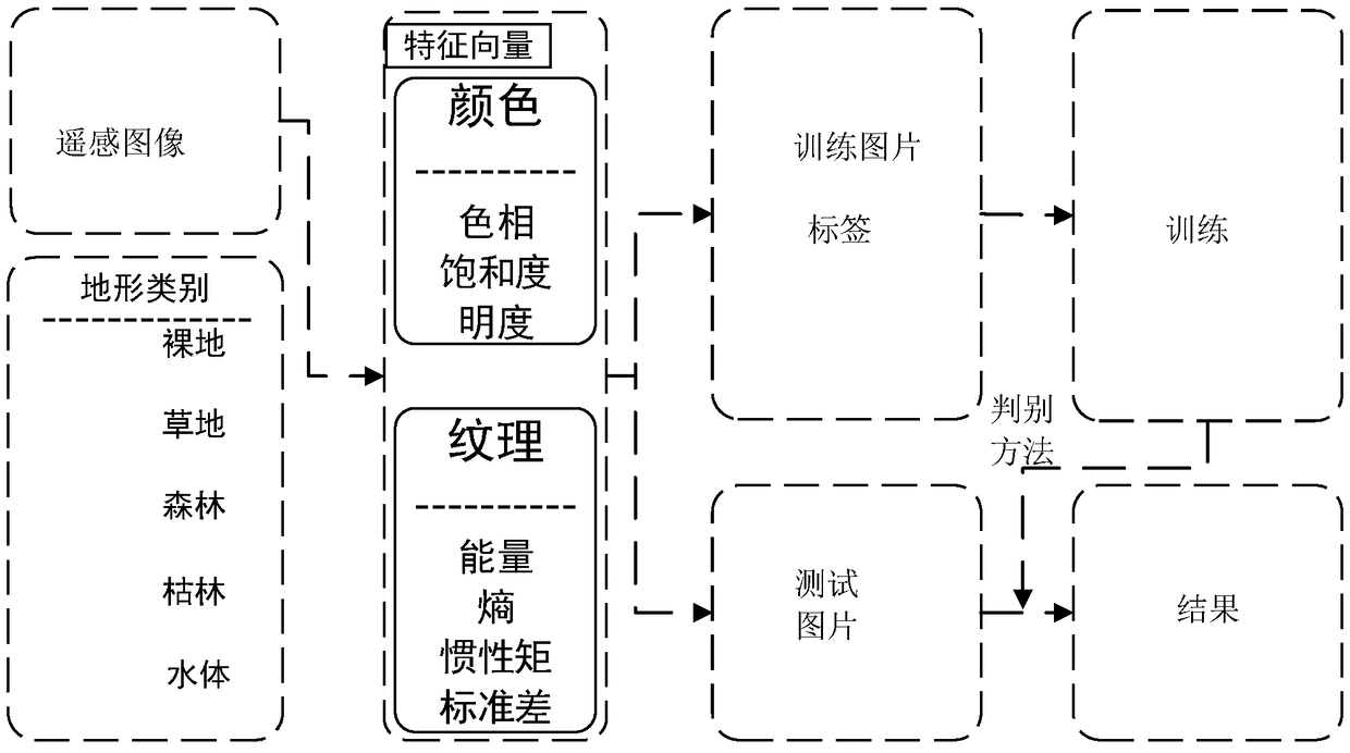
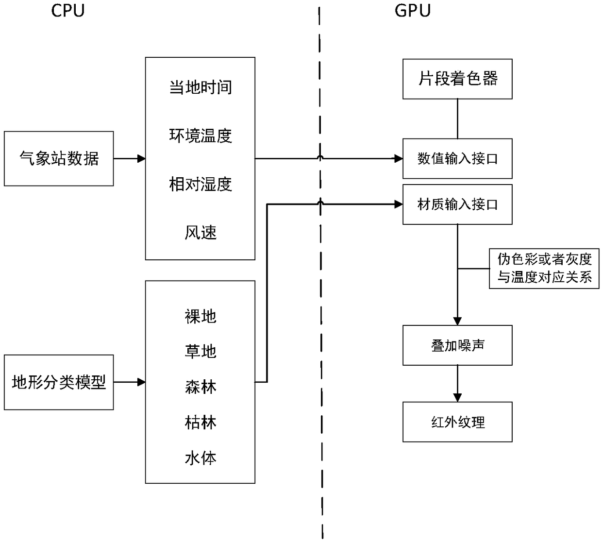
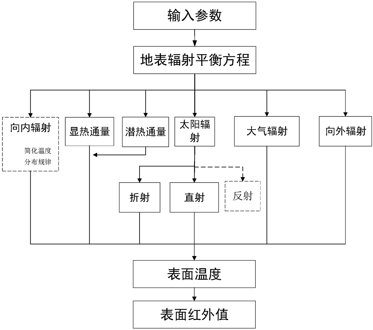
[0025] Aiming at the problem that large-scale infrared terrain scenes cannot be rendered in real time in the prior art, the present invention proposes a large-scale infrared terrain scene real-time rendering method based on visible light large-scale terrain remote sensing images to classify different features of large-scale terrain surfaces. The method first classifies the different features of different terrain surfaces based on visible light large-scale terrain remote sensing images, and establishes a terrain classification model; establishes a surface radiation model based on the different terrains, and calculates the different features from the surface energy balance equation. The terrain surface temperature value of the terrain, according to the fragment shader (shader), the terrain surface temperature value of each different terr...


PUM


Abstract

The invention discloses a remote sensing image classification based large-scale infrared terrain scene real-time rendering method and belongs to the technical field of infrared physics and virtual reality. The method includes steps of firstly establishing a terrain classification model; establishing a simplified terrain radiation model, calculating terrain surface temperature values of differentterrains, and converting the calculated terrain surface temperature values of the different terrains into color data according to a fragment shader, and adding infrared noise so as to realize infraredtexture rendering; finally, based on a cfMMOC model, performing real time rendering on infrared characteristics of large-scale terrain. The rendering flow of the invention is based on the cfMMOC model and a shader program, has high rendering efficiency, and can realize the real-time rendering of the global terrain infrared characteristics under a condition with low resource consumption. The framerate of the whole rendering process can be stabilized at more than 55 frames, which meets the real-time rendering conditions.

Description

technical field [0001] The invention belongs to the technical field of infrared physics and virtual reality, and relates to a large-scale infrared terrain scene real-time rendering method based on classification of remote sensing images, in particular to a large-scale method for classifying different features of large-scale terrain surfaces based on visible light terrain remote sensing images Real-time rendering method of infrared terrain scene. Background technique [0002] Infrared imaging simulation includes background imaging simulation and target imaging simulation. The target imaging simulation refers to the objects of interest in the simulation area, such as vehicles, buildings, etc., and the background is the scene other than the target. No target can be isolated from the background. However, it exists alone, and the large-scale terrain is a very typical type of background. Terrain infrared characteristics are a very important part of the entire infrared terrain sce...

Claims


Application Information

Patent Timeline
IPC IPC(8): G06T11/00G06K9/62G06K9/00
CPCG06T11/001G06T2207/20081G06T2207/10048G06T2207/10032G06V20/13G06F18/2411
Inventor 李妮李韧龚光红
Owner BEIHANG UNIV
Why Eureka
Try Eureka