A remote sensing satellite attitude planning method for multi-curvature dynamic imaging targets

A technology of dynamic imaging and remote sensing satellites, applied in satellite radio beacon positioning systems, integrated navigators, instruments, etc., to achieve the effect of smooth curvature

Active Publication Date: 2020-12-22
HARBIN ENG UNIV
View PDF4 Cites 1 Cited by
  • Summary
  • Abstract
  • Description
  • Claims
  • Application Information

AI Technical Summary

Problems solved by technology

[0003] The purpose of the present invention is to provide a remote sensing satellite attitude planning method for multi-curvature dynamic imaging targets in order to solve the problem of planning and solving the observation trajectory attitude information sequence when the observation target in the agile satellite imaging process is a multi-curvature curve

Method used


Image

  • A remote sensing satellite attitude planning method for multi-curvature dynamic imaging targets
  • A remote sensing satellite attitude planning method for multi-curvature dynamic imaging targets
  • A remote sensing satellite attitude planning method for multi-curvature dynamic imaging targets

Examples


Embodiment Construction

[0048] The present invention will be further described in detail below in conjunction with the accompanying drawings and specific embodiments.

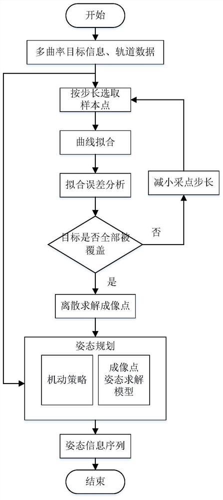
[0049] combine Figure 1 to Figure 5 , a remote sensing satellite attitude planning method for multi-curvature dynamic imaging targets of the present invention, comprising the following specific steps:

[0050] Step 1: Select sample points on the multi-curvature target trajectory with a certain step size, use the method of multi-section arc splicing to perform curve fitting on the sample points, and obtain the fitting error.

[0051] Step 2: If the margin of error is within the width coverage, discretely obtain the set of target imaging points on the fitted curve; otherwise, reduce the sampling step in step 1 to continue sampling, and repeat the above steps.

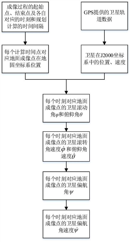
[0052] Step 3: Establish the attitude planning model of the imaging point, and solve the attitude information sequence of the observation trajectory during the imaging period. ...


PUM


Abstract

The invention provides a multi-curvature dynamic imaging target oriented remote sensing satellite attitude planning method. Points are collected on a multi-curvature target trajectory, and an arc splicing fitting method is utilized to obtain a feasible smooth curve with continuous curvature to represent the target trajectory finally. The observation process of the multi-curvature target is dividedinto an imaging time period and a maneuvering time period, discrete calculation of ground imaging points is carried out on a fitting curve, and an imaging point attitude solving model and a sinusoidal maneuvering path strategy are respectively employed to complete the attitude planning of the satellite imaging time period and maneuvering time period.

Description

technical field [0001] The invention relates to a remote sensing satellite attitude planning method, in particular to a remote sensing satellite attitude planning method for multi-curvature dynamic imaging targets, belonging to the field of imaging satellite task planning and attitude control. Background technique [0002] Agile remote sensing satellites have the ability to maneuver rapidly at large angles, and can achieve rapid imaging responses to ground observation targets, which is one of the main development directions of imaging satellites at present. In the traditional imaging mode, the satellite achieves straight-line coverage of the target through the swath. But for multi-curvature imaging targets, the imaging trajectory of satellites is any given curve with continuously changing curvature, and the satellite is required to complete ground observation along the curve. The imaging of multi-curvature targets requires the satellite to have sufficient maneuverability to...

Claims


Application Information

Patent Timeline
Patent Type & Authority Patents(China)
IPC IPC(8): G01C21/24G01S19/02
CPCG01C21/24G01S19/02
Inventor 赵琳高远刘源郝勇周俊峰赵坤柴毅崔文豪杨航王晴晴
Owner HARBIN ENG UNIV
Why Eureka
Try Eureka