
Remote sensing image-based mining area reclaimed land quality automatic evaluation method

A remote sensing image and quality evaluation technology, applied in the direction of instruments, data processing applications, resources, etc., can solve the problems of the lack of a unified acceptance standard for the evaluation index system, the lack of scientificity in the preparation of land reclamation planning, and insufficient consideration of land reclamation evaluation. problems, to achieve the effect of improving real-time and convenience, objective evaluation results, and good coordination

Pending Publication Date: 2018-12-07
HENAN POLYTECHNIC UNIV
View PDF5 Cites 8 Cited by
  • Summary
  • Abstract
  • Description
  • Claims
  • Application Information

AI Technical Summary

Problems solved by technology

On the one hand, insufficient consideration has been given to the evaluation of reclaimed land, and the preparation of land reclamation planning is not scientific, resulting in inaccurate evaluation results, making land reclamation unable to achieve its due purpose
On the other hand, in areas where land reclamation is carried out, although local governments have issued corresponding land reclamation acceptance regulations, they have not formed a mature evaluation index system and standardized and feasible unified acceptance criteria.

Method used


Image

  • Remote sensing image-based mining area reclaimed land quality automatic evaluation method
  • Remote sensing image-based mining area reclaimed land quality automatic evaluation method
  • Remote sensing image-based mining area reclaimed land quality automatic evaluation method

Examples


Embodiment

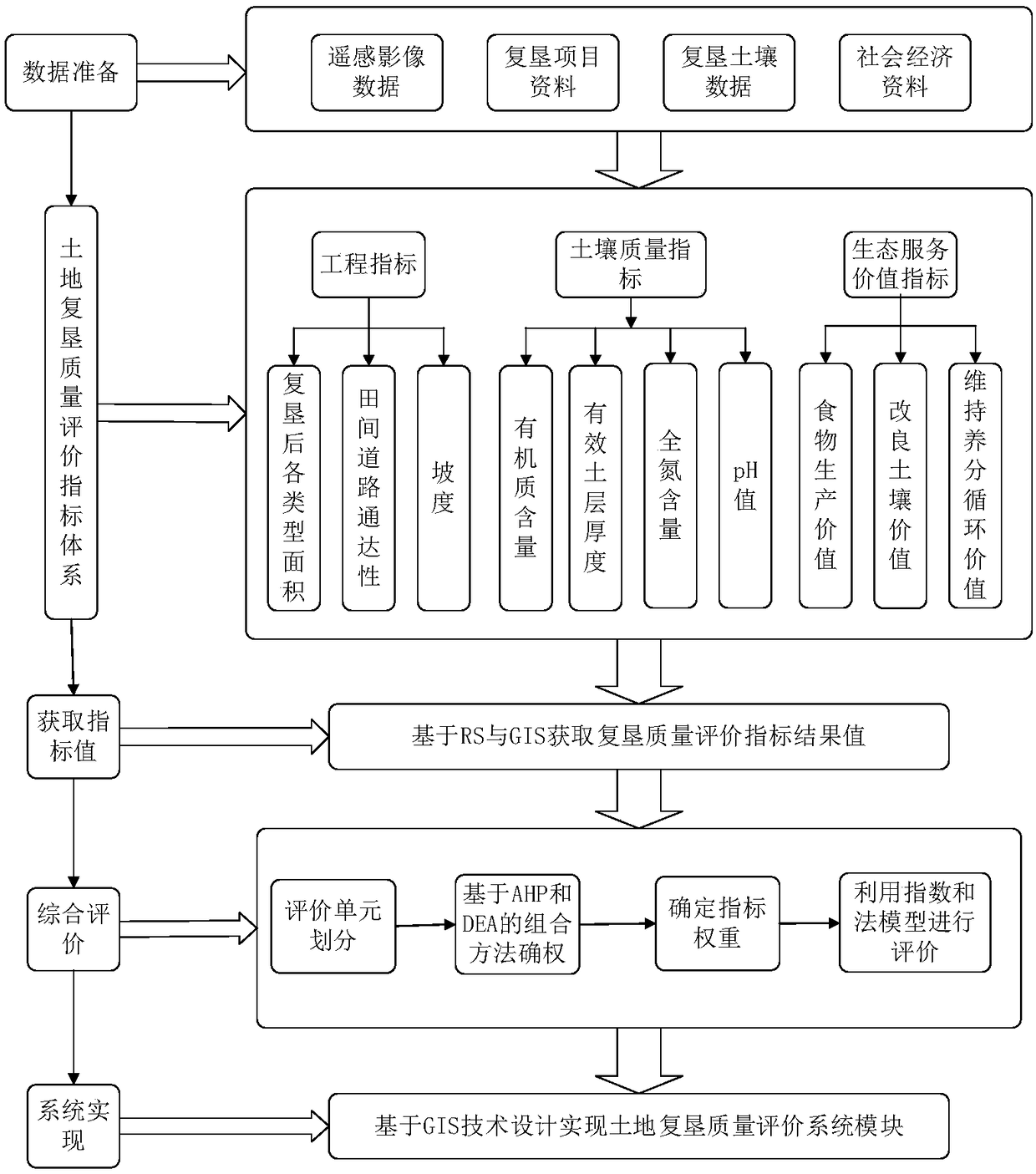
[0035] Such as figure 1 As shown, an automatic evaluation method for the quality of land reclamation in mining areas based on remote sensing images, including the following steps:

[0036] Stepl, data preparation, data collection on land reclamation in mining areas;

[0037] Step2. Construct the quality evaluation index system of reclaimed land in the mining area:

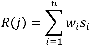
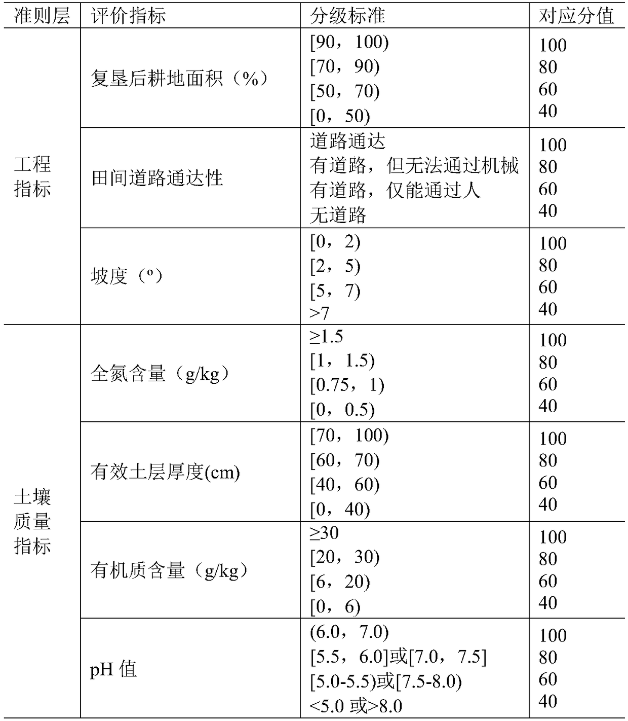
[0038] According to the existing national and local reclamation norms and technical standards, combined with the characteristics of land reclamation projects in mining areas, soil quality (including total nitrogen content, effective soil thickness, organic matter content and pH value), project quality (including reclamation The cultivated land area after reclamation, field road accessibility and slope) and ecological service value (including food production value, soil improvement value and nutrient cycle maintenance value), and determine the mining area reclamation project quality evaluation grading standard as s...


PUM


Abstract

The invention discloses a remote sensing image-based mining area reclaimed land quality automatic evaluation method. The method includes the following steps of: 1, data preparation; 2, mining area reclaimed land quality evaluation index system construction; 3, mining area land reclaimed land quality evaluation index calculation; and 4, mining area reclaimed land quality comprehensive evaluation. According to the remote sensing image-based mining area reclaimed land quality automatic evaluation method of the invention, a comprehensive quality evaluation index system in which index weights can be determined based on an AHP-DEA method is constructed from the perspectives of soil quality, project quality and ecological service value on the basis of the features of mining area land reclamationprojects and according to existing national and local reclamation norms and technical standards. Compared with a traditional land reclamation evaluation system, the method of the invention can bring more comprehensive indexes and more objective results. With the method of the invention adopted, the acceptance and examination of the mining area land reclamation projects can be managed more scientifically and efficiently; the real-time performance and convenience of the reclamation acceptance and examination work can be improved; the data of the projects can be digitized; evaluation models can be informationized; and coordination, management, and analysis can be better facilitated.

Description

technical field [0001] The invention relates to the technical field of land quality evaluation, in particular to an automatic evaluation method for reclaimed land quality in mining areas based on remote sensing images. Background technique [0002] Land reclamation is a complex systematic project. The data it processes involve many fields such as mining, geology, geography, ecology, agriculture, forestry, biology, soil, geochemistry, and social economy. It has a large amount of information, complex information attributes, and topological relationships. , the characteristics of large temporal and spatial changes of information. The reclamation work in our country is carried out relatively late, and the technology is relatively backward. The traditional working methods and management methods are no longer suitable for the current work needs, which makes the management department more and more powerless in guiding and managing the reclamation work. In recent years, the applica...

Claims


Application Information

Patent Timeline
IPC IPC(8): G06Q10/06G06Q50/26
CPCG06Q10/06395G06Q50/26
Inventor 王世东张游游张合兵石朴杰
Owner HENAN POLYTECHNIC UNIV
Learn More