InSAR two-dimensional earth surface deformation monitoring method based on adjacent track data

A technology of surface deformation and deformation, applied in the direction of electric/magnetic solid deformation measurement, measurement device, electromagnetic measurement device, etc., can solve the problem that InSAR technology cannot monitor two-dimensional surface deformation

Active Publication Date: 2018-12-11
北京东方至远科技股份有限公司
View PDF6 Cites 10 Cited by
  • Summary
  • Abstract
  • Description
  • Claims
  • Application Information

AI Technical Summary

Problems solved by technology

[0005] The present invention provides an InSAR two-dimensional surface deformation monitoring method based on adjacent track data. A Method for Monito

Method used


Image

  • InSAR two-dimensional earth surface deformation monitoring method based on adjacent track data
  • InSAR two-dimensional earth surface deformation monitoring method based on adjacent track data
  • InSAR two-dimensional earth surface deformation monitoring method based on adjacent track data

Examples


Embodiment Construction

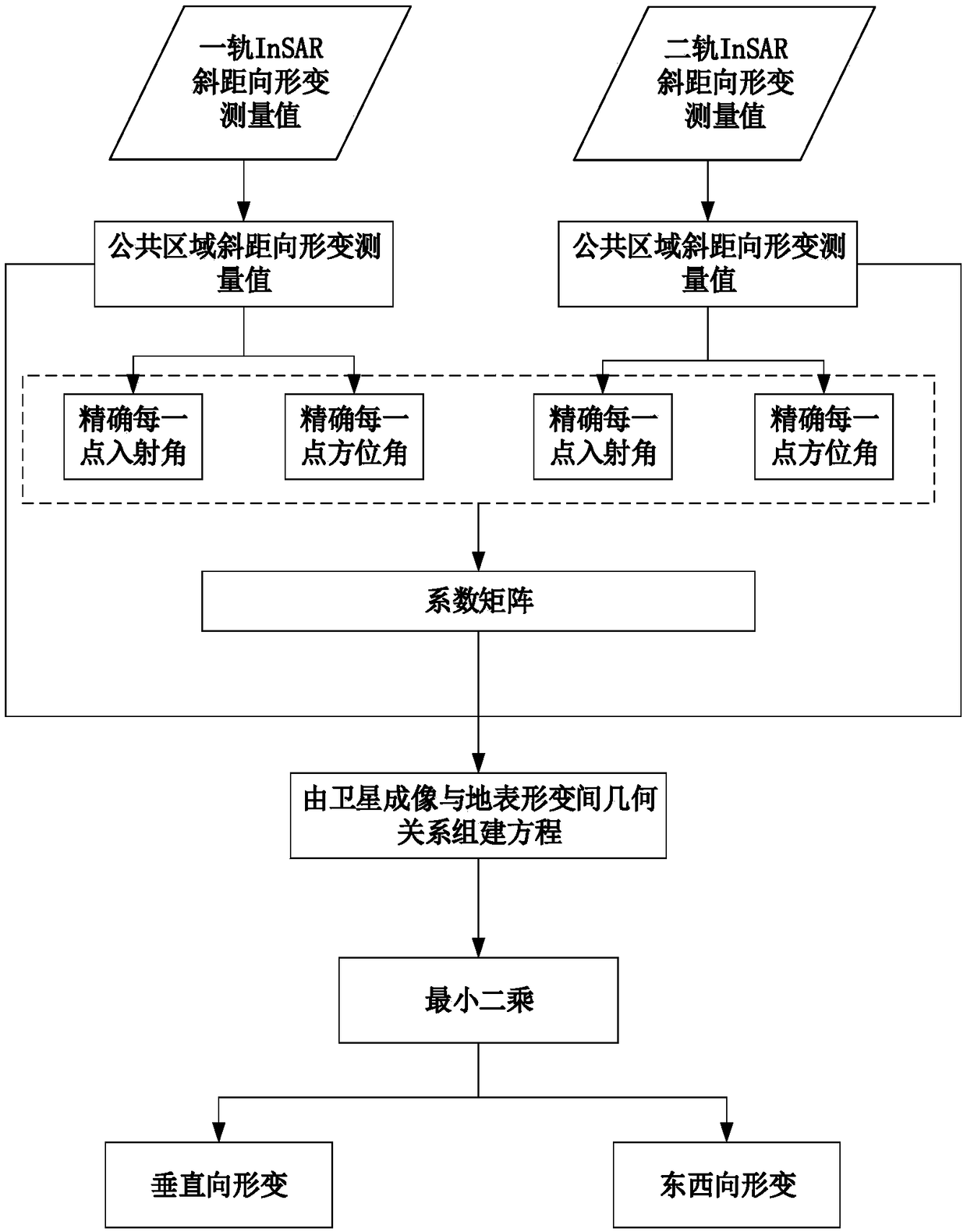
[0030] The present invention will be further described below in conjunction with the accompanying drawings and embodiments.

[0031] In order to facilitate understanding of the present invention, at first the theoretical basis of the present invention is provided:

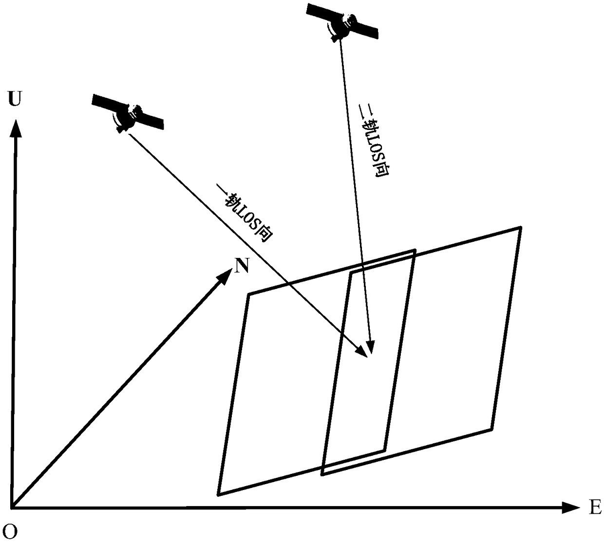
[0032] The SAR sensor flies over a certain point on the ground with a certain flight trajectory, and will record the phase and amplitude of the point in the LOS upward direction, and the surface deformation d of the point in the LOS upward direction can be obtained through D-InSAR technology. los . According to the imaging geometry of the satellite, the deformation in the LOS direction can be composed of vectors in the ground distance direction and the vertical direction:

[0033] d los =D U cosθ+D H sinθ (1)

[0034] Among them, D U and D Hrepresent the deformation vectors of the deformation in the vertical direction and the ground distance direction respectively, and θ is the incident angle of the satellit...


PUM


Abstract

The invention discloses an InSAR two-dimensional earth surface deformation monitoring method based on adjacent track data. The method comprises the following steps of firstly, using the SAR data of adjacent tracks to obtain the earth surface deformation measurement values of an earth surface at two different slant distance directions; then, acquiring two different slant distance direction deformation measurement values of the common area of adjacent tracks; calculating the incident angle and the azimuth of each point at first and second rails in the common area; and then, constructing the coefficient matrix for each point; and finally, according to the strict geometric relationship between the imaging geometry of a satellite and earth surface deformation, ignoring north-south deformation and establishing an equation set, and according to a least squares criterion, solving and acquiring earth surface two-dimensional deformation. In the invention, the technical bottleneck of InSAR two-dimensional deformation monitoring without a lifting track data area is broken through, an InSAR technology is actively promoted to develop towards a practical direction, and an important scientific value is possessed for studying a geophysical process and an inversion geological hazard parameter.

Description

technical field [0001] The invention belongs to the field of geodesy based on remote sensing images, in particular to an InSAR two-dimensional surface deformation monitoring method based on adjacent track data. Background technique [0002] Synthetic Aperture Radar Interferometry (InSAR) technology is a space geodetic and remote sensing method developed in recent decades. It is used for monitoring surface deformation caused by geological disasters such as earthquakes, volcanic eruptions, glacier drift, landslides, and debris flows. InSAR technology is currently the only space geodesy method that can observe slow surface deformation in a large range and with high spatial resolution. After years of development, the traditional differential InSAR (Differential InSAR, D-InSAR) technology has further evolved into a multi-temporal InSAR technology (Multi-Temporal InSAR, MT-InSAR), which has further advanced the technology to the practical aspect. . However, the deformation moni...

Claims


Application Information

Patent Timeline
IPC IPC(8): G01S13/90G01B7/16
CPCG01B7/16G01S13/90G01S13/9023
Inventor 胡俊张兴朱建军李志伟
Owner 北京东方至远科技股份有限公司
Why Eureka
Try Eureka