Navigation control method and system based on distance calculation

A control system and control method technology, applied in control/adjustment system, two-dimensional position/channel control, non-electric variable control, etc., can solve the problems of transportation not being delivered to the designated place in time, large driving error of GPS navigation, etc. Achieve the effect of small deviation, high accuracy and high efficiency

Inactive Publication Date: 2018-12-21
吴勇
View PDF5 Cites 6 Cited by
  • Summary
  • Abstract
  • Description
  • Claims
  • Application Information

AI Technical Summary

Problems solved by technology

[0002] With the improvement of people's living standards, the timeliness requirements of logistics transportation are also higher, and the needs of logistics vehicles and drivers are becoming more and more tense, especially the sharp increase in labor costs. How to reduce logistics costs has become a difficult problem in the transportation industry; therefore Some people have proposed unmanned transportation, and most of the schemes adopted are realized through GPS satellite navigation. However, due to the large driving error of GPS navigation, when driving on the road, if the vehicle deviates by a few meters or even more than ten meters, then It will be very dangerous, and the transportation cannot be delivered to the designated place in time; therefore, there is an urgent need for a driving method and a vehicle monitoring system that can automatically correct the vehicle position deviation and correct the driving path in time to improve the efficiency of vehicle transportation in the logistics park and reduce labor costs. cost

Method used


Image

  • Navigation control method and system based on distance calculation
  • Navigation control method and system based on distance calculation

Examples


Embodiment 1

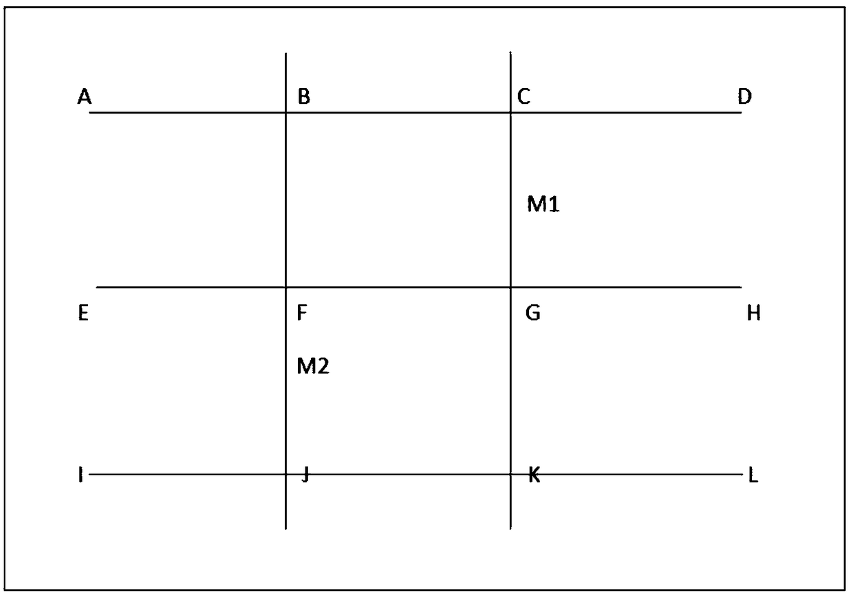
[0028] Such as Figure 1-2 As shown, the logistics road of the factory is as shown in the figure below (the distance between A-B and B-F is 10 meters, the lateral speed is 1 m / s, the vertical speed is 2 m / s, and the corners are 90°C)

[0029] If it is necessary to transport items from A to L, a route database is established, and the distance between the starting point and the end point of the route, the direction of the unmanned vehicle, and the corner of the road are input and stored in the storage module of the controller; To select the best route (such as the shortest route) in the storage module, you can choose route 1: A-B-C-G-K-L; route 2: A-B-F-J-K-L, route 3: A-B - One of F-G-K-L.

[0030] Positioning principle: If you choose route 1, the distance is a function of speed and time. When the driverless car travels 25 meters, the driverless car is located at the midpoint M1 of C-G; if you choose route 2, the driverless car travels 25 meters At this time, the unmanned veh...

Embodiment 2

[0035] The present invention can also be used in a home environment, for indoor delivery of meals, delivery of items and even cleaning; firstly establish a route database, for example, route S1 from the living room to the kitchen, route S2 from the living room to the balcony, route S3 from the living room to the bedroom, and route S3 from the living room to the kitchen. Route S4 is the route from the bedroom, route S5 is the route from the living room to the bathroom, and S6 is the route from the kitchen to the balcony. Input and store in the storage module of the controller and store in the storage module of the controller, and there is a two-dimensional code for calibration at the designated position on each route; when in use, if the elderly at home are inconvenient to walk, the meals in the kitchen will be sent to the It is necessary to walk back and forth many times to the dining table in the living room. At this time, you can put the meals on the driverless car, choose th...


PUM


Abstract

The invention discloses a navigation control method and system based on distance calculation. A controller of a driverless vehicle is provided with a unique identification code. The navigation controlmethod is characterized by comprising the following steps that a, a route database is established; b, a plurality of calibration devices are installed on routes stored in the step a; c, the routes are selected; d, the position of the driverless vehicle is calibrated; and e, when the driverless vehicle is driven on the designated route, an anti-collision sensor acquisition device of the driverlessvehicle collects information about obstacles within the set range around a vehicle body. The navigation control method and system based on the distance calculation realize a driving method and a vehicle monitoring system which can automatically correct the vehicle position deviation and timely correct the driving path, the vehicle transportation efficiency in a logistics park is improved, labor cost is reduced, or the navigation control method and system can be used in the family environment, indoor food delivery, goods delivery and even cleaning work.

Description

technical field [0001] The invention relates to the technical field of intelligent logistics transportation in logistics parks, in particular to a driving method based on distance calculation control and an unmanned vehicle monitoring system. Background technique [0002] With the improvement of people's living standards, the timeliness requirements of logistics transportation are also higher, and the needs of logistics vehicles and drivers are becoming more and more tense, especially with the sharp increase in labor costs. How to reduce logistics costs has become a difficult problem in the transportation industry; therefore Some people have proposed unmanned transportation, and most of the schemes adopted are realized through GPS satellite navigation. However, due to the large driving error of GPS navigation, when driving on the road, if the vehicle deviates by a few meters or even more than ten meters, then It will be very dangerous, and the transportation cannot be delive...

Claims


Application Information

Patent Timeline
Patent Type & Authority Applications(China)
IPC IPC(8): G05D1/02
CPCG05D1/021G05D1/0223G05D1/0231
Inventor 吴勇
Owner 吴勇
Why Eureka
Try Eureka