
Multi-line Road Extraction Method Based on Moment of Inertia Based Compactness Density Peak Clustering

A technology of compactness and moment of inertia, applied in image analysis, image enhancement, instruments, etc., can solve problems such as incomplete coverage of sample data sets, difficulty in obtaining sample data sets, and low accuracy of classification results, so as to avoid difficult to determine, The effect of reducing dependencies and high robustness

Inactive Publication Date: 2021-05-28
CHINA UNIV OF GEOSCIENCES (WUHAN)
View PDF4 Cites 0 Cited by
  • Summary
  • Abstract
  • Description
  • Claims
  • Application Information

AI Technical Summary

Problems solved by technology

[0003] However, this existing multi-line road extraction method has certain limitations:
First of all, it is difficult to obtain sample data sets, and the incomplete coverage of sample data sets will lead to low accuracy of classification results

Method used


Image

  • Multi-line Road Extraction Method Based on Moment of Inertia Based Compactness Density Peak Clustering
  • Multi-line Road Extraction Method Based on Moment of Inertia Based Compactness Density Peak Clustering
  • Multi-line Road Extraction Method Based on Moment of Inertia Based Compactness Density Peak Clustering

Examples


Embodiment Construction

[0021] In order to make the purpose, technical solution and advantages of the present invention clearer, the embodiments of the present invention will be further described below in conjunction with the accompanying drawings.

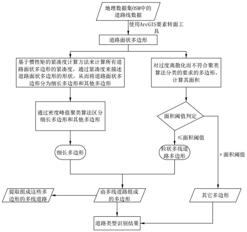
[0022] Embodiments of the present invention provide a method for extracting multi-line roads based on the compactness density peak clustering of moments of inertia. The roads in the geographic data set OSM include single-line roads and multi-line roads, and the polygons composed of single-line roads represent blocks. Polygons composed of multi-line roads represent road surfaces, and the goal of this method is to extract the multi-line roads that make up these polygons by extracting the polygons composed of multi-line roads.

[0023] Please refer to figure 1 , the method includes the steps of:

[0024] S1: Obtain the geographic dataset OSM, and use the ArcGIS feature-to-surface tool to convert the road line data in the geographic dataset OSM into road su...


PUM


Abstract

The present invention provides a method for extracting multi-line roads based on the compactness density peak clustering of moment of inertia. The roads in the geographical data set OSM include single-line roads and multi-line roads. Convert the road line data into road surface polygons; S2 calculates the compactness of all road surface polygons based on the compactness calculation method of moment of inertia, describes the shape of road surface polygons through compactness, and uses the density peak clustering algorithm to distinguish For slender polygons and other polygons, extract slender polygons; S3 calculates the area of ​​all road surface polygons, and determines the area threshold according to the maximum width between two adjacent multi-line roads in the geographical dataset OSM, and the extracted area is less than the area Thresholded polygons; S4 extracts the multiline roads that make up these polygons by extracting polygons.

Description

technical field [0001] The invention relates to the technical field of road extraction, in particular to a multi-line road extraction method based on compactness density peak clustering of moments of inertia. Background technique [0002] At present, for the problem of multi-line road extraction of OpenStreetMap (OSM) data that lacks quality control, the extraction method based on polygonal polygons is generally used. The existing multi-lane road extraction method is an article published by Li Qiuping in the International Journal of Geographical Information Science: Polygon-based approach for extracting multilane roads from OpenStreetMap urban roadnetworks (Li Q, Luan X, Luan X, et al. Polygon-based approach for extracting multilane roads from OpenStreetMap urban road networks [J]. International Journal of Geographical Information Science, 2014, 28(11): 2200-2219.). This method first converts the road line data into polygonal polygons, uses five polygonal characteristic par...

Claims


Application Information

Patent Timeline
Patent Type & Authority Patents(China)
IPC IPC(8): G06K9/62G06T7/62G06T7/66
CPCG06T7/62G06T7/66G06T2207/10004G06F18/2321
Inventor 吴坤坤胡茂胜
Owner CHINA UNIV OF GEOSCIENCES (WUHAN)
Learn More