
High-precision map making method orienting port unmanned container truck

A production method and card collection technology, which can be used in the re-radiation of electromagnetic waves, radio wave measurement systems, satellite radio beacon positioning systems, etc., and can solve problems such as difficult production and inability to meet the needs of autonomous driving.

Inactive Publication Date: 2019-01-04
北京主线科技有限公司
View PDF6 Cites 28 Cited by
  • Summary
  • Abstract
  • Description
  • Claims
  • Application Information

AI Technical Summary

Problems solved by technology

However, sometimes this method cannot meet the needs of automatic driving
Especially for port container trucks, their driving trajectories are quite special, and it is difficult for general automation programs or map cartographers to produce intersections that meet the needs of autonomous driving for unmanned trucks

Method used


Image

  • High-precision map making method orienting port unmanned container truck
  • High-precision map making method orienting port unmanned container truck
  • High-precision map making method orienting port unmanned container truck

Examples


Embodiment

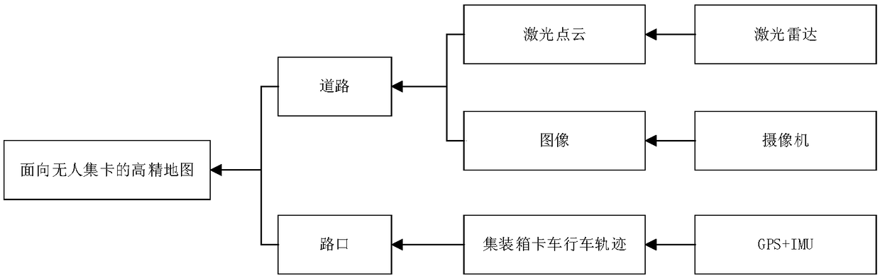
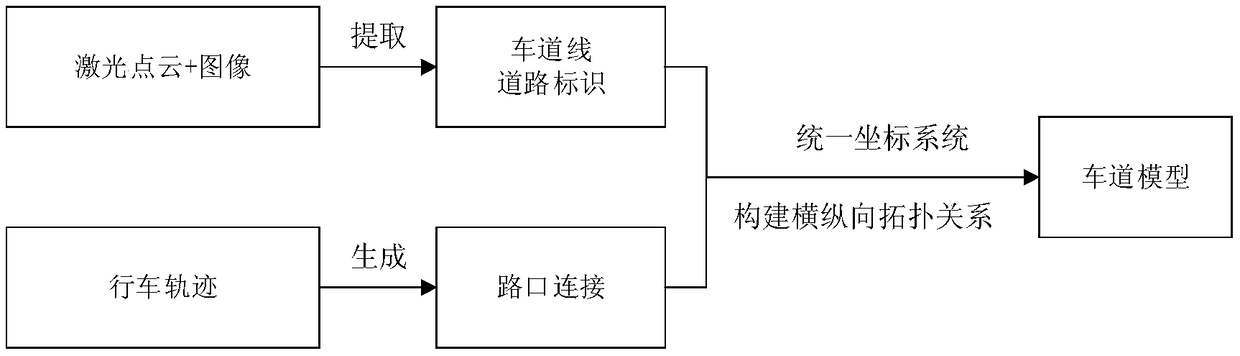
[0017] A high-precision map production method for port unmanned collection trucks. The hardware solution is as follows: two Velodyne 16-line laser radars, one on the left and right sides of the unmanned collection truck head, with a viewing range of 270 degrees and a height of 1.5 meters from the ground ;Three BASLER+KOWO cameras, one of which is fixed in the front windshield for front view, and the other two are respectively fixed on the left and right sides of the vehicle body, at a height of 1.5 meters from the ground; the navigation system is installed with ins550 integrated navigation system In the middle of the roof. The characteristics of this method are: using the combination of laser point cloud and image processing to extract road signs and obtain road information with lane lines; using GPS and IMU to obtain the driving trajectory of unmanned trucks to generate the basis of lane lines without lane line intersection connections, To create a high-precision map with no ...


PUM


Abstract

The invention relates to a high-precision map making method orienting a port unmanned container truck. The high-precision map making method is characterized in that road markings are extracted by combining laser point cloud and image processing, and the road information with lane lines is obtained; and the driving trajectories of the unmanned container truck are obtained by using GPS and IMU so asto generate the lane line basis of unmanned truck lane line intersection connection and make the high-precision map of the unmanned container truck. The beneficial effects are that as for the bottleneck of no lane line at the intersection of the special scene of the port, the general automated program or map maker has difficulty to draw the intersection meeting the automatic driving requirement of the unmanned container truck, and the high-precision map orienting the port unmanned container truck is made by using the mode of combining laser point cloud and image processing.

Description

technical field [0001] The invention belongs to the field of map making, and in particular relates to a high-precision map making method for unmanned truck collection in ports. Background technique [0002] With the development of automation technology and unmanned driving technology, automated container terminals are the future development trend of ports. Due to the particularity of container terminal scenarios, how to accurately obtain high-precision maps to popularize unmanned ports has become a major problem. In real life, the method of producing high-precision maps based on laser point clouds and images can only be effective when lane lines actually exist. For the acquisition of high-precision maps of intersections without lane lines, it is usually automatically generated by the automation software that produces high-precision maps based on certain rules or drawn by cartographers based on personal experience. However, sometimes this method cannot meet the needs of auto...

Claims


Application Information

Patent Timeline
IPC IPC(8): G01S17/89G01C11/02G01C21/32G01C21/16G01S19/47
CPCG01C11/02G01C21/165G01C21/32G01S17/89G01S19/47
Inventor 朱园媛何贝张天雷刘鹤云
Owner 北京主线科技有限公司
Learn More