Real-time network RTK positioning method compatible with quasi-geoid model
A geoid, real-time network technology, applied in the direction of satellite radio beacon positioning system, height/horizontal measurement, surveying device, etc.
- Summary
- Abstract
- Description
- Claims
- Application Information
AI Technical Summary
Problems solved by technology
Method used
Image

Examples
Embodiment Construction
[0031] The present invention will be further explained below in conjunction with the accompanying drawings and specific embodiments. It should be understood that the following specific embodiments are only used to illustrate the present invention and are not intended to limit the scope of the present invention.
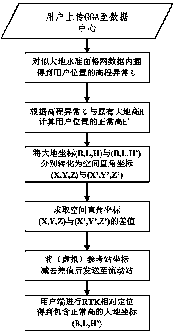
[0032] A kind of real-time network RTK positioning method compatible with quasi-geoid model described in the present invention, such as figure 1 shown, including the following steps:
[0033] Step 1. According to the latitude and longitude and geodetic height provided by GGA (Global Positioning System Fix Data), the rough position of the user's mobile station is obtained. In the data processing center, according to the geodetic coordinates B and L of the user's rough position, the quasi-geoid grid is used The data and the elevation anomaly interpolation function calculate the elevation anomaly and normal height of the user's approximate position;
[0034] Step 2: Sub...
PUM
 Abstract
Description
Claims
Application Information
 - R&D
- Intellectual Property
- Life Sciences
- Materials
- Tech Scout
- Unparalleled Data Quality
- Higher Quality Content
- 60% Fewer Hallucinations
Browse by: Latest US Patents, China's latest patents, Technical Efficacy Thesaurus, Application Domain, Technology Topic, Popular Technical Reports.
© 2025 PatSnap. All rights reserved.Legal|Privacy policy|Modern Slavery Act Transparency Statement|Sitemap|About US| Contact US: help@patsnap.com