A vector element change comparison method based on similarity

A similarity and element technology, applied in the field of geographic data update, can solve the problems of complex spatial element mapping and changes in multi-source geographic data, and achieve the effect of reducing the scope of comparison, improving efficiency and ensuring reliability.

Active Publication Date: 2019-01-04
ZHEJIANG INST OF SURVEYING & MAPPING SCI & TECH +1
View PDF5 Cites 10 Cited by
  • Summary
  • Abstract
  • Description
  • Claims
  • Application Information

AI Technical Summary

Problems solved by technology

[0003] Among them, detecting and discovering the mapping and changes between geographic elements is the premise of data update, and it is also the focus and difficulty of this problem. The mapping and changes of spatial elements in multi-source geographic data are relatively complicated.

Method used


Image

  • A vector element change comparison method based on similarity
  • A vector element change comparison method based on similarity

Examples


Embodiment Construction

[0026] The following will clearly and completely describe the technical solutions in the embodiments of the present invention with reference to the accompanying drawings in the embodiments of the present invention. Obviously, the described embodiments are only some, not all, embodiments of the present invention. All other embodiments obtained by persons of ordinary skill in the art based on the embodiments of the present invention belong to the protection scope of the present invention.

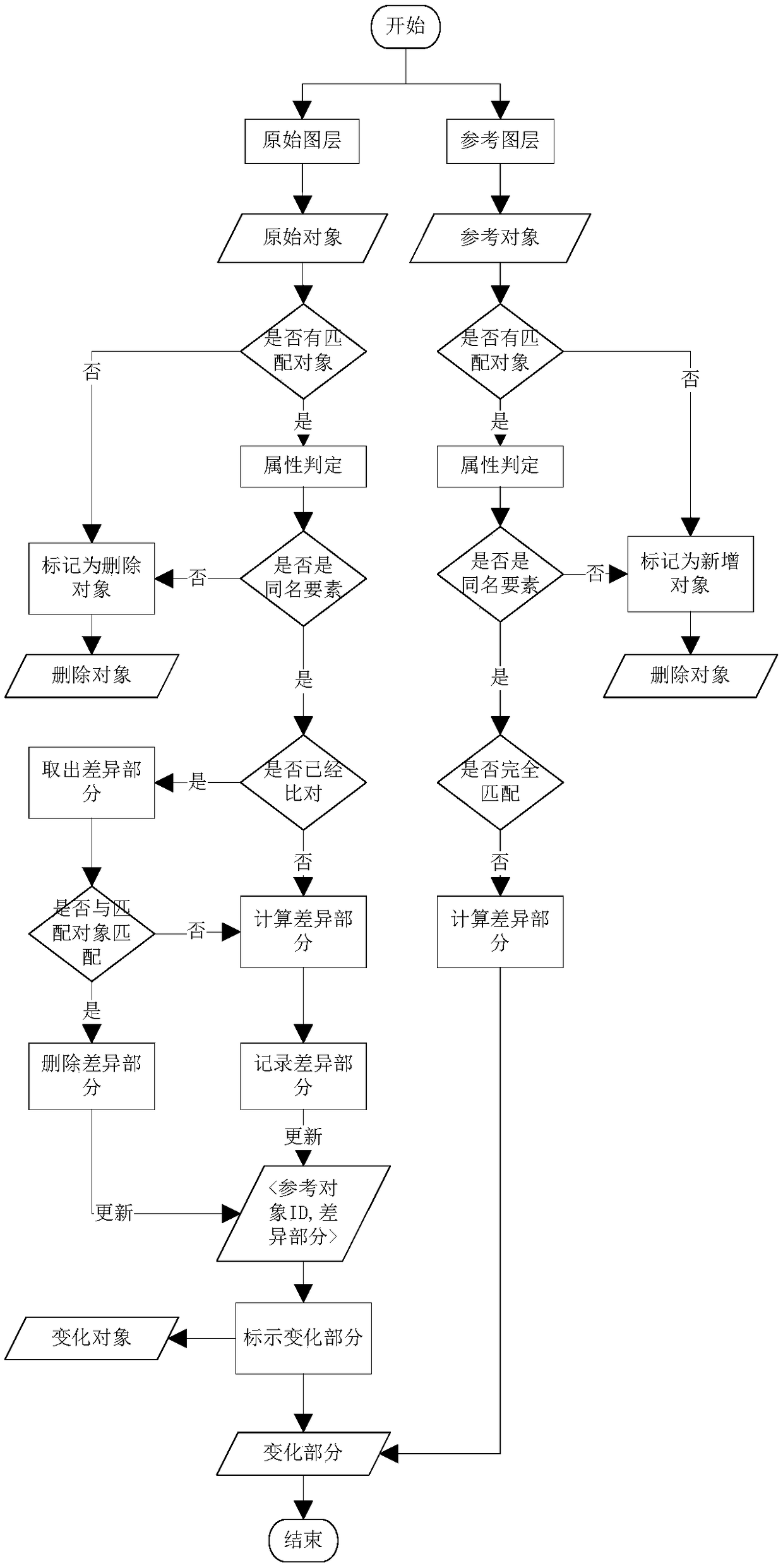
[0027] like figure 2 As shown, a similarity-based vector element change comparison method according to an embodiment of the present invention includes the following steps:

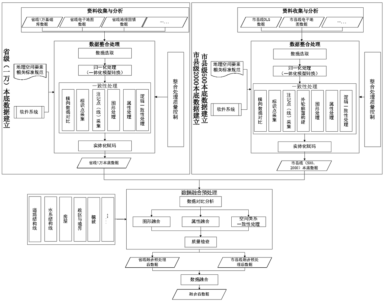
[0028] S1 normalizes the data and integrates it into a unified data carrier;

[0029] S2 Establish a knowledge rule base and define knowledge rules, including:

[0030] S21 Determine the change ratio threshold of each element in the basic geographic data and the circumstances of the change, as well as the processing of...


PUM


Abstract

The invention discloses a vector element change comparison method based on similarity degree. The method comprises the following steps: first, data being normalized so as to have the same spatial reference; second, establishing a knowledge rule base and determining knowledge rules, which mainly includes data analysis and change definition; third, data alignment and updating. The invention has thebeneficial effects that the accuracy and efficiency of the target identification are improved by combining the buffer area, the spatial index, the key attribute and the spatial similarity, and the reliability of the change detection result is ensured; at the same time, the invention proposes a whole set of element comparison and linkage update flow based on similarity, which can directly guide vector element comparison and update production activities.

Description

technical field [0001] The invention relates to the technical field of geographic data updating, in particular to a method for comparing changes of vector elements based on similarity. Background technique [0002] The update of geospatial data has replaced the production of geospatial data as the core and bottleneck of GIS development (Uitermark et al., 1998, Fritsch, 1999), because the current situation of data directly affects its application value, and then affects the development and development of GIS. application. Article 15 of Chapter III of the "Surveying and Mapping Law of the People's Republic of China" revised in 2005 stipulates: "Basic surveying and mapping results should be updated regularly, and basic surveying and mapping results that are urgently needed for national economy, national defense construction, and social development should be updated in a timely manner. Basic surveying and mapping results The update cycle is determined according to the needs of ...

Claims


Application Information

Patent Timeline
Patent Type & Authority Applications(China)
IPC IPC(8): G06F16/909
Inventor 叶哲璐杜维龚丽芳周海鹏胡冯伟黄桦张铭晓吴梦然
Owner ZHEJIANG INST OF SURVEYING & MAPPING SCI & TECH
Why Eureka
Try Eureka