Remote sensing estimation method and device and readable storage medium for thickness of permafrost active layer
A technology for estimating device and active layer, applied in the field of remote sensing, can solve the problems of difficulty in obtaining the thickness of active layer, high cost, time-consuming and labor-intensive, etc.
- Summary
- Abstract
- Description
- Claims
- Application Information
AI Technical Summary
Problems solved by technology
Method used
Image

Examples
Embodiment 1
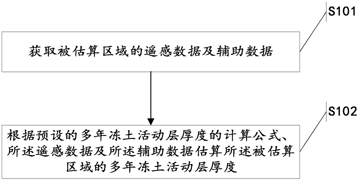
[0052] Please refer to figure 1 , figure 1 It is a schematic flowchart of the method for estimating the thickness of the permafrost active layer based on remote sensing provided by Embodiment 1 of the present invention. Said estimation methods include:
[0053] Step S101: Obtain remote sensing data and auxiliary data of the area to be estimated;
[0054] Step S102: Estimate the thickness of the permafrost active layer in the estimated area according to the preset calculation formula for the thickness of the permafrost active layer, the remote sensing data and the auxiliary data.
[0055] It should be noted that the remote sensing data include: surface temperature melting index DDT, annual average leaf area index LAI, and snow cover days SnowD, and the auxiliary data include related soil data, and the categories of the related soil data include: soil sand particles Content Sand, soil clay content Clay, soil silt content Silt, soil organic carbon content Org and soil density ...
Embodiment 2
[0101] Please refer to Figure 4 , Figure 4 It is a functional block diagram of a remote sensing estimation device for permafrost active layer thickness provided by Embodiment 2 of the present invention. The remote sensing estimation device is used for estimating the thickness of the permafrost active layer, and includes: an acquisition unit 201 and a processing unit 202 .
[0102] The acquisition unit 201 is used to acquire remote sensing data and auxiliary data of the area to be estimated. The remote sensing data includes: surface temperature melting index DDT, annual average leaf area index LAI and snow days SnowD. The auxiliary data includes relevant soil data, so The categories of related soil data include: soil sand content Sand, soil clay content Clay, soil silt content Silt, soil organic carbon content Org and soil density Bld;
[0103] The processing unit 202 is used to estimate the thickness of the permafrost active layer in the estimated area according to the pre...
Embodiment 3
[0129] Embodiment 3 of the present invention provides a readable storage medium, and a computer program is stored in the readable storage medium. When the computer program runs on a computer, the computer executes the remote sensing-based remote sensing method described in Embodiment 1. method of estimating. The present invention will not repeat this.
PUM
 Abstract
Description
Claims
Application Information
 - R&D
- Intellectual Property
- Life Sciences
- Materials
- Tech Scout
- Unparalleled Data Quality
- Higher Quality Content
- 60% Fewer Hallucinations
Browse by: Latest US Patents, China's latest patents, Technical Efficacy Thesaurus, Application Domain, Technology Topic, Popular Technical Reports.
© 2025 PatSnap. All rights reserved.Legal|Privacy policy|Modern Slavery Act Transparency Statement|Sitemap|About US| Contact US: help@patsnap.com