
Assisted positioning method for lane line on the basis of high-accuracy map and scene retrieval

An auxiliary positioning and lane line technology, applied to road network navigators and other directions, can solve the problems of reference lane line deviation from the correct lane, high cost, difficult mass production, etc., and achieve the effect of lowering the threshold of use

Active Publication Date: 2019-01-11
禾多科技(北京)有限公司
View PDF13 Cites 16 Cited by
  • Summary
  • Abstract
  • Description
  • Claims
  • Application Information

AI Technical Summary

Problems solved by technology

[0004] Obviously, there is also a problem with the low-precision GPS positioning based on the high-precision lane line map, that is, the high-precision lane line map will receive an inaccurate position and send a reference lane line based on this position, and the reference lane line is very accurate. It may have deviated from the correct lane, so that the currently detected lane line refers to the wrong lane line, resulting in unreliable positioning information
High-precision GPS positioning based on high-precision lane line maps can completely avoid this problem, but it will again face the disadvantages of high cost and difficult mass production

Method used


Image

  • Assisted positioning method for lane line on the basis of high-accuracy map and scene retrieval
  • Assisted positioning method for lane line on the basis of high-accuracy map and scene retrieval
  • Assisted positioning method for lane line on the basis of high-accuracy map and scene retrieval

Examples


Embodiment Construction

[0037] The present invention will be further described in detail below in conjunction with the accompanying drawings, so that those skilled in the art can implement it with reference to the description.

[0038] It should be understood that terms such as "having", "comprising" and "including" used herein do not exclude the presence or addition of one or more other elements or combinations thereof.

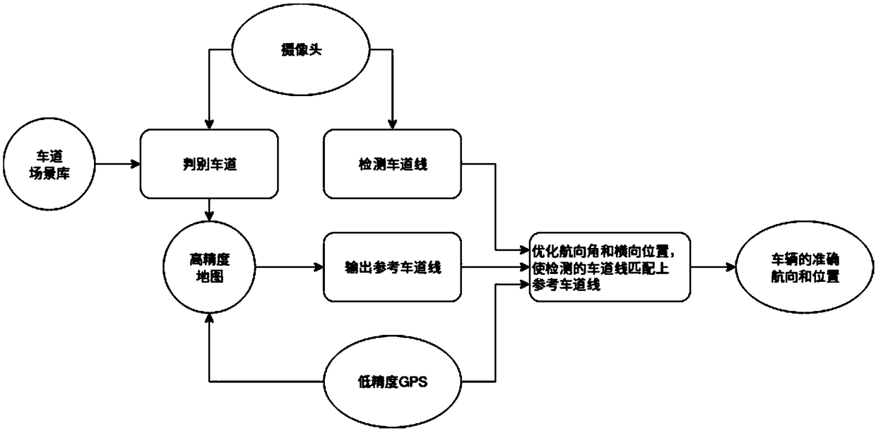
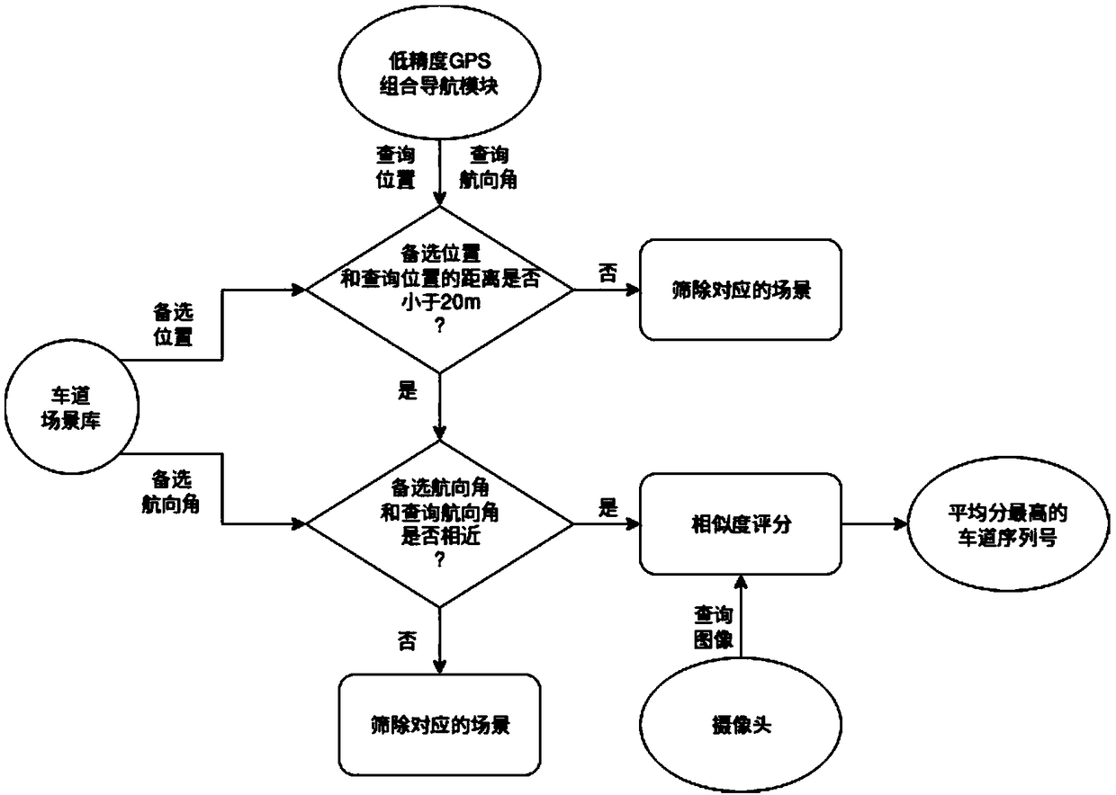
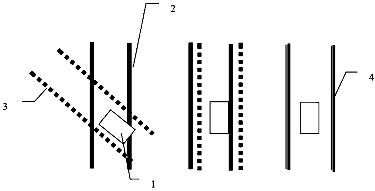
[0039] Such as Figure 1-3 As shown, the present invention provides a lane line auxiliary positioning method based on high-precision maps and scene retrieval, which mainly includes the following steps:

[0040] Step 1. Use high-precision GPS to collect the lane line position of the road, and establish a high-precision lane line map.

[0041] Step 2. Collect scene data containing scene images at different points of different lanes in the high-precision lane line map, and establish a lane scene library, wherein the scene images in the lane scene library are used as reference images,...


PUM


Abstract

The invention discloses an assisted positioning method for lane line on the basis of high-accuracy map and scene retrieval. The method mainly comprises the following steps that: establishing a high-accuracy lane line map; establishing a lane scene library, wherein a scene image in the lane scene library is taken as a reference image, and a reference lane serial number is marked in the reference image; collecting a scene image by a vehicle to serve as a current image, comparing the current image with the reference image in the lane scene library to obtain a proximate reference image, and obtaining a reference lane serial number from the proximate reference image; adopting a low-accuracy GPS (Global Positioning System) by the vehicle to obtain low-accuracy position information, sending the low-accuracy position information and the reference lane serial number to a high-accuracy GPS (Global Positioning System), combining the high-accuracy GPS with the low-accuracy position information andthe reference lane serial number to give the current correct lane line of the vehicle; detecting the current lane line by the vehicle, and regulating the current pose of the vehicle by taking the correct lane line as a standard to enable the vehicle to be matched with the correct lane line.

Description

technical field [0001] The invention relates to the technical field of automatic driving vehicle positioning, in particular to a lane line auxiliary positioning method based on high-precision maps and scene retrieval. Background technique [0002] At present, in the field of autonomous vehicle positioning technology, there are two most representative solutions: 1) using a low-cost and low-precision integrated navigation module based on the global positioning system (hereinafter referred to as low-precision GPS); 2) using high-cost and high-precision High-precision integrated navigation module based on the global positioning system (hereinafter referred to as high-precision GPS). Solution 1 is restricted by GPS performance, and the positioning error can reach several meters to tens of meters, which cannot meet the needs of automatic driving. The cost of the high-precision GPS used in the second option is often hundreds of thousands of yuan. The high price is difficult to ach...

Claims


Application Information

Patent Timeline
IPC IPC(8): G01C21/30
CPCG01C21/30
Inventor 袁帅骆沛李超
Owner 禾多科技(北京)有限公司
Learn More