Method and system for rapid risk classification of rainstorm secondary geological hazards in power network passageway

A technology of geological disasters and channels, which is applied in the rapid risk division method and system field of heavy rain secondary geological disasters in power grid channels, can solve the problems of difficulty in implementation, large manpower and material resources, and cost, and achieve clear thinking, strong practicability, and accuracy high rate effect

Inactive Publication Date: 2019-01-11
STATE GRID HUNAN ELECTRIC POWER +2
View PDF3 Cites 8 Cited by
  • Summary
  • Abstract
  • Description
  • Claims
  • Application Information

AI Technical Summary

Problems solved by technology

[0004] The present invention provides a method and system for rapid risk division of heavy rain secondary geological disasters in power grid channels, which are used to solve the technical problem that...

Method used


Image

  • Method and system for rapid risk classification of rainstorm secondary geological hazards in power network passageway
  • Method and system for rapid risk classification of rainstorm secondary geological hazards in power network passageway
  • Method and system for rapid risk classification of rainstorm secondary geological hazards in power network passageway

Examples


Embodiment 1

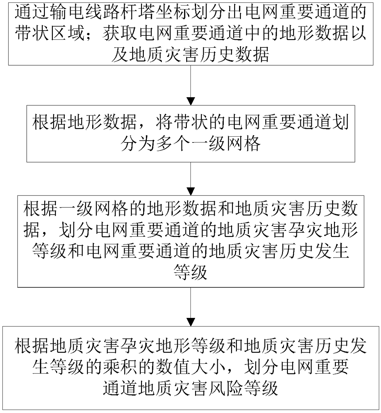
[0042] The method for quickly dividing the risk of secondary geological disasters caused by heavy rain in the power grid channel of this embodiment includes the following steps:

[0043] S1: Divide the belt-shaped area of ​​the important channel of the power grid through the coordinates of the transmission line tower; obtain the terrain data and historical data of geological disasters in the important channel of the power grid.

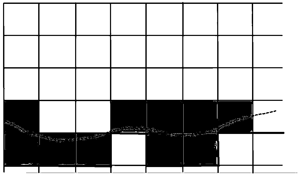
[0044] S2: Based on the 100m*100m high-precision elevation data in the digital elevation model DEM terrain data, the strip-shaped power grid important channels are divided into 100m*100m first-level grids, because the edge of the power grid important channel area and the DEM elevation terrain data network There will be some incomplete first-level grids on the edge of the important channel area of ​​the power grid, and the edge range of the transmission channel area should be adjusted appropriately to make up all these incomplete grids into a complete f...

Embodiment 2

[0059] This embodiment is an application example of Embodiment 1. This embodiment takes Hunan Province as an example to illustrate the application of the method for rapid risk classification of secondary geological disasters caused by heavy rain in power grid channels in Embodiment 1.

[0060] The method for quickly dividing the risk of secondary geological disasters caused by heavy rain in the power grid channel of this embodiment includes the following steps:

[0061] (1) Data collection.

[0062] Taking the operation and maintenance power grid area of ​​Hunan Provincial Electric Power Company of the State Grid as an example, the data required in the present invention mainly include two types, which are respectively the gridded terrain elevation data of Hunan Province 100m*100m in the digital elevation model DEM data, and Hunan Power Grid 2008 -In 2017, the data of secondary geological disasters caused by heavy rain near all 220kV and above lines.

[0063] (2) Divide the ba...

Embodiment 3

[0079] This embodiment provides a computer system, including a memory, a processor, and a computer program stored in the memory and operable on the processor. When the processor executes the computer program, the steps in any of the foregoing embodiments are implemented.

[0080] In summary, the present invention overcomes the shortcomings of the prior art that rely on one-by-one investigations of geological disasters in power transmission channels, and has a large workload. By using the terrain data of the GIS terrain digital elevation model DEM and the historical data of geological disasters in important channels of the power grid, the important channels of the power grid can be completed. Rapid classification of the risk of geological disasters secondary to heavy rain.


PUM


Abstract

The invention discloses a method and a system for rapid risk classification of rainstorm secondary geological hazards in a power network passageway. The method comprises the following steps: dividinga belt-shaped area of an important power network channel by pole and tower coordinates of a transmission line; acquiring topographic data and historical data of geological hazards in important channels of power network; according to the terrain data, dividing an important channel of the belt-shaped power network into a plurality of first-level grids; according to the topographic data of the firstgrid and the historical data of geological hazards, dividing the geological hazard grades of the important routes of the power network and the historical occurrence grades of the geological hazards ofthe important routes of the power network; according to the product of geological hazard terrain grade and geological hazard history grade, dividing the geological hazard risk grade of the importantpassageway of the power network. The invention utilizes topographic data and geological hazard historical data of an important channel of a power network, and can realize rapid division of the secondary geological hazard risk of a rainstorm in the important channel of the power network.

Description

technical field [0001] The invention relates to the field of power grid protection, in particular to a method and system for quickly dividing the risks of geological disasters secondary to rainstorms in power grid channels. Background technique [0002] Rainstorm disasters occur frequently in summer in my country, which will bring a large amount of precipitation in a short period of time, which will have a huge scouring effect on the earth's surface and easily cause secondary geological disasters. Among them, secondary geological disasters caused by rainstorms in important power grid passages seriously threaten the safety of the power grid, ranging from damage to the base of towers, to tilting, deformation, and collapse of towers and causing line failures. There are two characteristics of rainstorm secondary geological disasters in the power grid channel. One is the frequent occurrence of disasters. Due to the developed power grid in my country and the large cross-regional t...

Claims


Application Information

Patent Timeline
IPC IPC(8): G06Q10/06G06Q50/06
CPCG06Q10/0635G06Q50/06
Inventor 陆佳政李丽杨莉李波简洲郭俊
Owner STATE GRID HUNAN ELECTRIC POWER
Why Eureka
Try Eureka