
Road engineering earthwork quantity high-precision calculation method based on BIM technology

A technology of road engineering and calculation method, applied in calculation, image data processing, 3D modeling, etc., can solve the problems of large earthwork error in road engineering and unfavorable refined cost management, so as to improve calculation accuracy and promote refined management , good adaptability effect

Active Publication Date: 2019-01-11
李东帅
View PDF3 Cites 13 Cited by
  • Summary
  • Abstract
  • Description
  • Claims
  • Application Information

AI Technical Summary

Problems solved by technology

[0004] The technical problem to be solved by the present invention is that the existing calculation method of earthwork calculation method produces large errors in calculating the earthwork volume of road engineering, which is unfavorable for refined cost management

Method used


Image

  • Road engineering earthwork quantity high-precision calculation method based on BIM technology
  • Road engineering earthwork quantity high-precision calculation method based on BIM technology
  • Road engineering earthwork quantity high-precision calculation method based on BIM technology

Examples


Embodiment 1

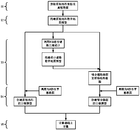
[0029] A high-precision calculation method for road engineering earthwork volume based on BIM technology, comprising the following steps:

[0030] Step 1. Import the original terrain data:

[0031]The first step in calculating the earthwork volume of road engineering is to collect the original terrain DEM data. The DEM data includes two kinds of information, the plane position and the elevation data. For the collection of DEM data, it can be measured directly in the field with a total station or GPS laser rangefinder, or indirectly obtained from aerial images and existing topographic maps.

[0032] Step 2, constructing the digital ground model of the original terrain surface:

[0033] Import the original terrain data obtained in Step 1 into Civil3D, construct a TIN surface in Civil3D, and construct a spatial delaunay TIN. The TIN construction method used here is a two-dimensional projection method, and its construction principle is: the original terrain The DEM data is proje...

Embodiment 2

[0041] A high-precision calculation method for road engineering earthwork volume based on BIM technology is also applicable to the calculation of excavated and filled earthwork volume for site leveling in civil engineering. Since the calculation method proposed by the present invention is universal, its steps and principles Similar to Embodiment 1.

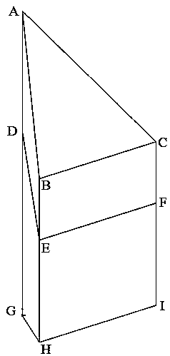
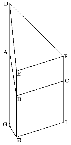
[0042] According to the steps described in Embodiment 1, the digital ground model of the original terrain is constructed, such as Figure 10 shown. The digital ground model of the stitched surface is constructed as Figure 11 Shown; the constructed original terrain 3D model and stitched surface 3D model are shown as Figure 12 and Figure 13 Shown; the common parts of the two 3D models are as Figure 14 shown.

[0043] Similar to the embodiment, when calculating the volume of excavated and filled soil for site leveling, it can be considered that the original surface 3D model is excavated to the public part 3D model, so the ex...


PUM


Abstract

The invention discloses a road engineering earthwork quantity high-precision calculation method based on BIM technology, which solves the technical problem that the error generated by calculating theroad engineering earthwork quantity by using the existing earthwork quantity calculation method is large. The method comprises the following steps: 1, obtaining the DEM data point cloud of the original terrain; 2, according to the DEM data cloud of the original terrain, fitting the original terrain surface of the original terrain; 3, constructing a design surface model of the engineering project,and stitching the design surface model to the original terrain surface fitted in the step 2; 4, taking the horizontal datum surface with the elevation of 0 as the bottom surface, respectively constructing the three-dimensional models of the original terrain surface and the suture surface; 5, analyzing the three-dimensional model constructed in step 4 and calculating the earthwork quantity of the project. The invention adopts the BIM technology and the three-dimensional modeling software, and puts forward a high-precision calculation method for the accounting problem of earthwork quantity in the road engineering.

Description

technical field [0001] The invention relates to the field of highway traffic, in particular to a BIM technology-based high-precision calculation method for road engineering earthwork volume. Background technique [0002] In road engineering, it is often necessary to level the ground such as trenching and filling. Among them, the accounting of the quantity of engineering earthwork is an important task in road engineering, and it is also an important indicator for road engineering cost accounting. [0003] The existing calculation method of earthwork for road engineering at home and abroad is the section method. The basic idea of ​​the cross-section method is to assume that the cross-sectional area between two adjacent filling and excavation sections changes with a specific law, calculate the amount of earthwork between the two sections according to the area of ​​the two adjacent filling and excavation sections and the distance between the sections, and calculate the amount o...

Claims


Application Information

Patent Timeline
Patent Type & Authority Applications(China)
IPC IPC(8): G06T17/20G06T17/05G06Q50/08
CPCG06Q50/08G06T17/05G06T17/20Y02A90/10
Inventor 李东帅李振杰宋新刚黄靖宇晁睿杰范嘉逸高阳李辉柏
Owner 李东帅
Learn More