
Method, device and system for dynamic resource selection based on geographic location

A technology of geographic location and dynamic resources, applied in the field of Internet of Vehicles, can solve the problems of waste of resource blocks, reduce the reliability of communication systems, and resource shortages, reduce frequent collisions and idle resources, improve communication reliability, and improve resource utilization. rate effect

Active Publication Date: 2020-10-02
BEIJING UNIV OF POSTS & TELECOMM
View PDF8 Cites 0 Cited by
  • Summary
  • Abstract
  • Description
  • Claims
  • Application Information

AI Technical Summary

Problems solved by technology

At the same time, there may be no VUE or very few VUEs in some areas, but this area is still mapped to a sub-resource pool of normal size, resulting in most resources in the sub-resource pool being wasted
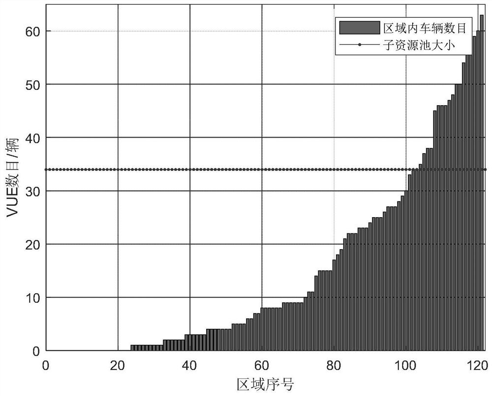
For example, see figure 2 as shown, figure 2 According to the statistics of the number of VUEs in each geographical area divided according to the existing technology, the horizontal line represents the number of resource blocks included in each sub-resource pool, and it can be observed that the number of VUEs in a large part of the area is much lower than figure 2 The middle horizontal line, even some areas where there is no VUE at all, are still mapped to a normal-sized sub-resource pool, resulting in a large number of resource blocks being wasted
At the same time, the number of VUEs in some areas is higher than the horizontal line, and the resources are not enough, which leads to collisions and reduces the reliability of the communication system
[0006] It can be seen that this kind of resource shortage and resource waste caused by the existing resource partition mechanism greatly reduces the communication reliability when using the geographic location-based resource selection algorithm

Method used


Image

  • Method, device and system for dynamic resource selection based on geographic location
  • Method, device and system for dynamic resource selection based on geographic location
  • Method, device and system for dynamic resource selection based on geographic location

Examples


Embodiment 1

[0047] The present invention designs a set of dynamic resource selection mechanism based on geographic location by using methods such as clustering and adjusting the size of sub-resource pools.

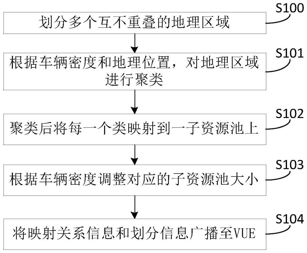
[0048] Embodiment 1 of the present invention provides a dynamic resource selection method based on geographic location, see image 3 shown, including steps:

[0049] Step S100, dividing the entire area within the coverage of the base station into multiple non-overlapping geographical areas.

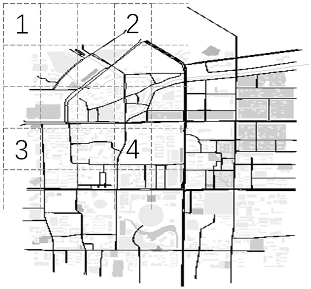
[0050] The base station divides the entire area within its coverage area into a number of equal-area non-overlapping geographical areas. The size of each area should be smaller than the vehicle communication range. If the vehicle communication distance is α meters, then the distance of the longest diagonal of each area should be less than α meters. In general, α is 300 meters.

[0051] Step S101, according to vehicle density and geographic location, cluster all geographical areas within the c...

Embodiment 2

[0058] Embodiment 2 of the present invention provides a preferred embodiment of a dynamic resource selection method based on geographic location.

[0059] Step S200, dividing geographical regions.

[0060] The geographic area division in Embodiment 2 is the same as in Embodiment 1, and will not be repeated here.

[0061] Step S201, collect the number of VUEs in each area, group geographical areas with similar vehicle density and far distance into one category, and map each type of geographical area to a sub-resource pool.

[0062] The VUE within the coverage of the base station will report its location periodically, with a period of β milliseconds. The base station collects the location information to count the number of VUEs in each area. Here we define the number of VUEs in each area as the vehicle density in the area. Therefore, each area has two characteristics, the first is the vehicle density, that is, the number of VUEs, and the second is the location of the geograph...

Embodiment 3

[0084] The present invention also provides a dynamic resource selection device based on geographic location, which is installed on the side of the base station and used to divide the entire area within the coverage of the base station into multiple non-overlapping geographic areas; obtain the vehicle density of each geographic area According to the vehicle density and geographical location, cluster all geographical areas within the coverage of the base station; after clustering, each class is mapped to a sub-resource pool, forming a many-to-one from geographical area to sub-resource pool Mapping; adjust the size of the corresponding sub-resource pool according to the vehicle density of each class after clustering; broadcast the mapping relationship information of the many-to-one mapping and the adjusted corresponding sub-resource pool division information to the VUE.


PUM


Abstract

The present invention discloses a dynamic resource selection method, device and system based on a geographic position. The method comprises the steps of: dividing a whole area in a base station coverage range into a plurality of geographic areas to obtain vehicle density and the geographic position of each geographic area and perform cluster of all the geographic areas in the base station coveragerange; mapping each class to one sub resource pool after clustering to form many-for-one mapping; according to the vehicle density, regulating the size of the corresponding sub resource pool; and broadcasting a division result to a VUE. The device is arranged at the side of the base station is used to execute the mentioned steps. The system comprises a base station side and a VUE side, the VUE side is used to determine the geographic area of the VUE itself; and according to the mapping relation information and the sub resource pool division information, the required resource block is selectedaccording to the energy detection algorithm. The dynamic resource selection method, device and system improve the communication reliability compared to the static resource selection algorithm based on the geographic position.

Description

technical field [0001] The present invention relates to the technical field of Internet of Vehicles, in particular to a dynamic resource selection method, device and system based on geographic location in LTE-V2V. Background technique [0002] Intelligent Transportation System (Intelligent Transportation System, ITS) is a real-time, accurate and comprehensive traffic management system, which is considered to be the mainstream development direction of the transportation field. The Internet of Vehicles technology is the core of the Intelligent Transportation System. At present, the standardization work of Long Term Evolution-Vehicle (LTE-V) based on LTE network has been completed, which includes vehicle-to-vehicle communication (Vehicle to Vehicle, V2V), vehicle-to-pedestrian communication (Vehicle to Pedestrian, V2P) and Vehicle to Infrastructure / Network (V2I / N) communication modes. [0003] In the V2V communication mode, the vehicle communication equipment (Vehicle User Eq...

Claims


Application Information

Patent Timeline
Patent Type & Authority Patents(China)
IPC IPC(8): H04W4/02H04W4/021H04W4/06H04W4/40H04W28/04H04W64/00
CPCH04W4/021H04W4/025H04W4/06H04W4/40H04W28/04H04W64/00
Inventor 顾昕钰丁伊张琳
Owner BEIJING UNIV OF POSTS & TELECOMM
Learn More