A method for accurately settling agricultural disaster claim based on remote sensing data and digital field

A remote sensing data and disaster technology, applied in image data processing, data processing applications, instruments, etc., can solve the problems of farmers missing the best replanting, crop rotation, cumbersome claims procedures, waste of resources, etc., to avoid moral hazard, avoid On-site survey tasks, saving manpower and material resources

Inactive Publication Date: 2019-01-18
安徽阡陌网络科技有限公司
View PDF3 Cites 10 Cited by
  • Summary
  • Abstract
  • Description
  • Claims
  • Application Information

AI Technical Summary

Problems solved by technology

The claims procedure is cumbersome and takes 2-3 months, which may easily cause farmers to miss the best replanting and crop rotation seasons
At the same time, due to the explosive and concentrated characteristics of disasters, there is often a shortage of manpower for centralized loss assessment, and a large number of repeated on-site disaster investigations have caused unnecessary waste of resources.
Grassroots staff have moral hazards in the process of claim settlement. Due to differences in personal work attitudes and moral standards, the results of on-site inspections vary significantly. There have been frequent violations of laws and regulations such as fraudulent claims at the grassroots level, fraudulent claims from the central government, and violations of farmers’ rights and interests. National finances have brought a lot of losses

Method used


Image

  • A method for accurately settling agricultural disaster claim based on remote sensing data and digital field

Examples


Embodiment

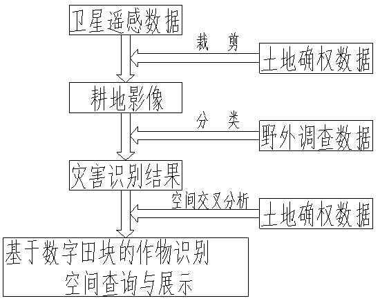
[0018] Step 1, outdoor investigation: after the occurrence of agricultural disasters, obtain relevant satellite image data in time, initially analyze the distribution of disasters, and send ground investigators to the suspected disaster areas to conduct on-the-spot investigations, record the GPS coordinates of the sample points, the disaster situation, And take pictures on the spot, and send back the information and sample reports of the disaster site in time;

[0019] Step 2, image interpretation: screen out the best remote sensing image data before and after the disaster, use the digital field data to crop the image data, superimpose the field disaster investigation results on the cropped data, and analyze and compare the spectral differences in the target area , by manually selecting training samples, using remote sensing classification technology, using computer automatic identification and manual interaction, to interpret the affected area and distribution of crops;

[00...


PUM


Abstract

The invention provides a method for accurately settling agricultural disaster claim based on remote sensing data and digital field, involving remote sensing technology, GPS technology, GIS technology,Using high-definition remote sensing image data (remote sensing satellite data or aerial photograph data of unmanned aerial vehicle) and ground survey data to interpret the disaster situation of crops, digital field data is combined to accurately locate the scale of farmers and fields, so as to realize online inquiry of agricultural disaster degree and disaster area according to the information of the fields and the right holders. The invention provides a method for accurately settling agricultural disaster claim based on remote sensing data and digital field, which only needs to sample the disaster areas with different degrees and a small number of people to carry out on-the-spot investigation to realize fast, Accurate identification and inquiry of the disaster situation of each farmer and field, not only improving the work efficiency, but also saving a lot of manpower and material resources in agricultural insurance claim settlement.

Description

technical field [0001] The invention mainly relates to the technical field of agricultural insurance, in particular to a method for precise claims settlement for agricultural disasters based on remote sensing data and digital fields. Background technique [0002] In the process of agricultural disaster claims, at present, it mainly goes through the process of disaster reporting, disaster survey and loss determination, publicity, and loss compensation. Disaster survey and damage assessment mainly rely on grassroots staff of insurance units to take pictures on the spot and measure the disaster area, which requires a lot of manpower and material resources. The claims procedure is cumbersome and takes 2-3 months, which can easily cause farmers to miss the best replanting and crop rotation seasons. At the same time, due to the explosive and concentrated characteristics of disasters, there is often a shortage of manpower for centralized loss assessment, and a large number of repe...

Claims


Application Information

Patent Timeline
Patent Type & Authority Applications(China)
IPC IPC(8): G06Q40/08G06T7/00G06T7/11G06T7/62
CPCG06Q40/08G06T7/0002G06T7/11G06T7/62G06T2207/30188G06Q50/02G06Q50/26G06Q10/10G06Q10/063
Inventor 张民江勇周祥张道祥
Owner 安徽阡陌网络科技有限公司
Why Eureka
Try Eureka