A system and method for simultaneous display of real-time video and geographic location information

A technology for simultaneous display of geographical location information, applied in closed-circuit television systems, television, image communication, etc., can solve the problems of low information display efficiency and inability to display video sources well

Inactive Publication Date: 2019-01-22
STATE GRID CORP OF CHINA +2
View PDF6 Cites 4 Cited by
  • Summary
  • Abstract
  • Description
  • Claims
  • Application Information

AI Technical Summary

Problems solved by technology

Obviously, the display efficiency of information in this way is relatively low, and when there are multiple video sources and the video sources are geographically far apart, it is generally impossible to display the geographical location information of each video source well.

Method used


Image

  • A system and method for simultaneous display of real-time video and geographic location information
  • A system and method for simultaneous display of real-time video and geographic location information
  • A system and method for simultaneous display of real-time video and geographic location information

Examples


Embodiment Construction

[0038] Below in conjunction with accompanying drawing, the present invention is described in further detail:

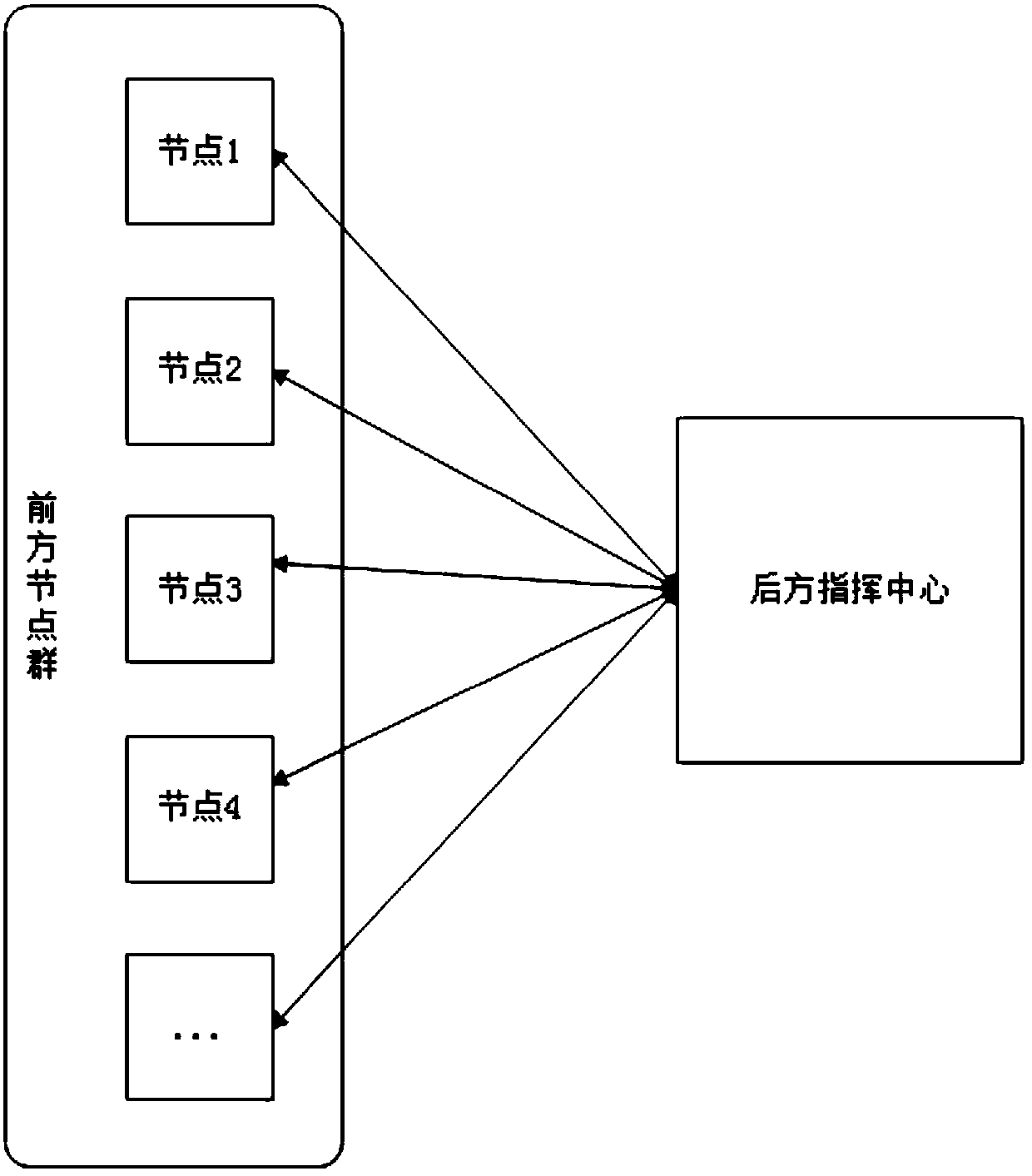
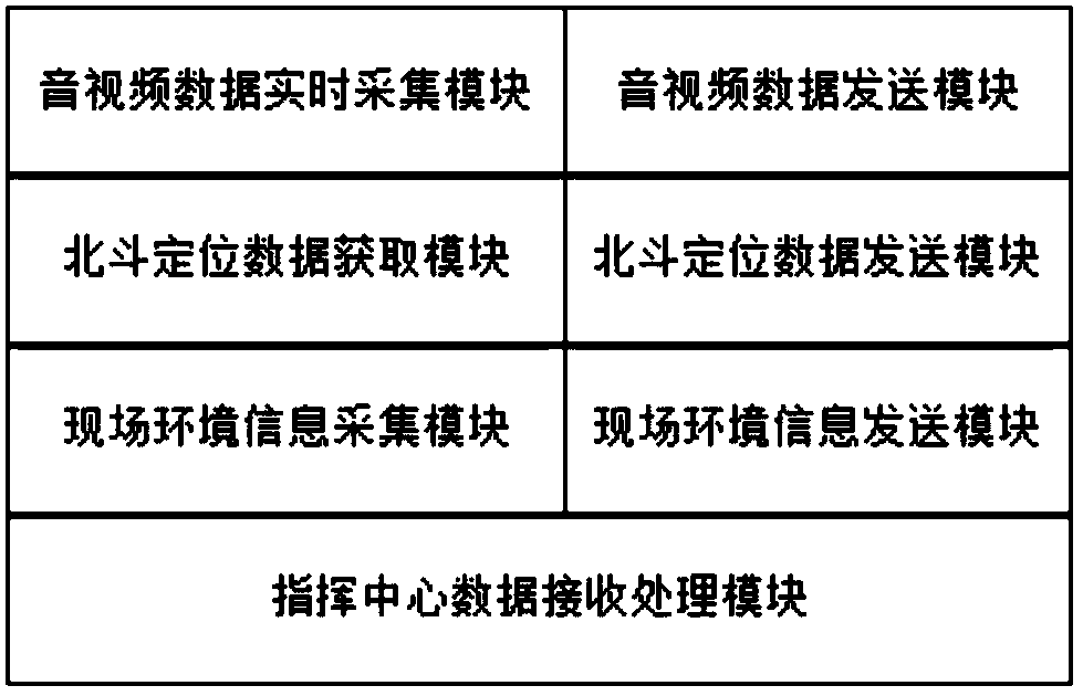
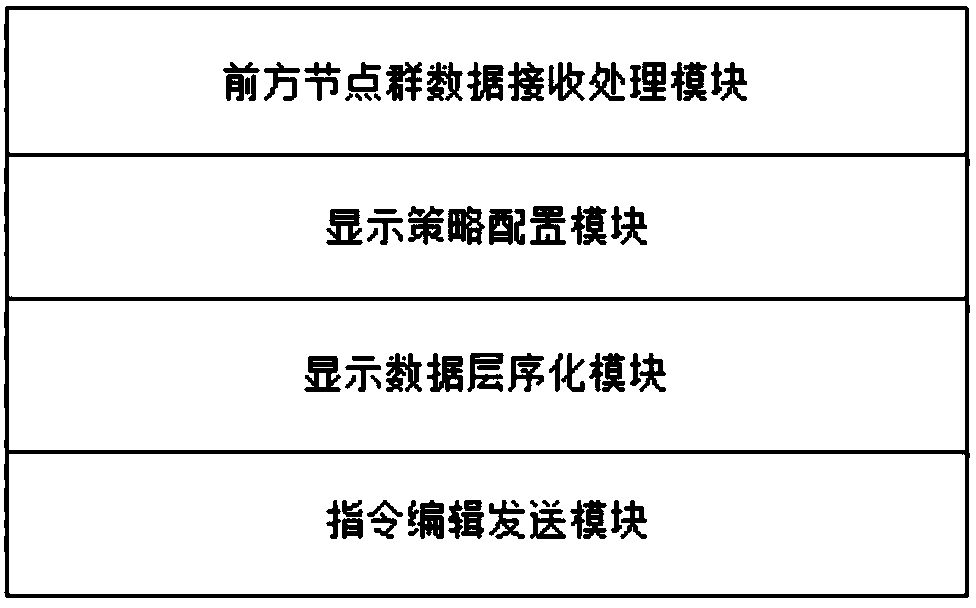
[0039] The system of the invention is composed of a front node group and a rear command center node, and the front node and the rear command center perform two-way communication through a wireless link. The front node collects data, sends the data to the rear command center node, and the rear command center node receives the data of each front node, processes the data, and then displays it on the display screen. In the opposite direction, the rear command center node can also send data to the front node, and make unified command and dispatch for the front node. The system structure is as follows: figure 1 shown.

[0040]The front node is generally located on site, and the available two-way communication links include Beidou short message, Tiantong satellite SMS, Tiantong satellite phone, and 3G and 4G links if there is operator network coverage. The rear node is loc...


PUM


Abstract

The invention discloses a system and a method for simultaneously displaying real-time video and geographic location information; the system comprises a front node group and a rear command center node,wherein the front node group comprises a plurality of front nodes used for collecting live audio and video data and geographic position information, and the front node and the rear command center node perform bi-directional communication through a wireless link. The front node group comprises a plurality of front nodes for collecting live audio and video data and geographic position information.The invention can simultaneously display the real-time video, the corresponding geographic position information and the environment information, at the same time, the display layout can be conveniently adjusted, the fusion display of a plurality of nodes is supported, and the information display mode is unique and efficient.

Description

technical field [0001] The invention relates to the field of information display, in particular to a system and method for simultaneously displaying real-time video and geographic location information. Background technique [0002] With the development of technology, the technical means used in disaster prevention, mitigation, disaster relief and emergency command posts are also changing, from the early simple walkie-talkies to handheld phones to wireless audio and video conferences based on 3G / 4G technology, the coverage is getting wider and wider , the information presentation methods are becoming more and more abundant. In areas where there is no signal or the signal base station is damaged, the introduction of satellite phone and satellite positioning technology provides the most direct and important information guarantee for emergency rescue. Utilizing the positioning and information transmission technology provided by domestic Beidou satellite and Tiantong satellite, ...

Claims


Application Information

Patent Timeline
Patent Type & Authority Applications(China)
IPC IPC(8): H04N7/18
CPCH04N7/181
Inventor 王晓明郭云涛曾维欢房涛胡鑫宋辉姬晓文袁多丽王维新李朝晖李国朝岳维功杨林春杨树峰陈刚刘庚
Owner STATE GRID CORP OF CHINA
Why Eureka
Try Eureka